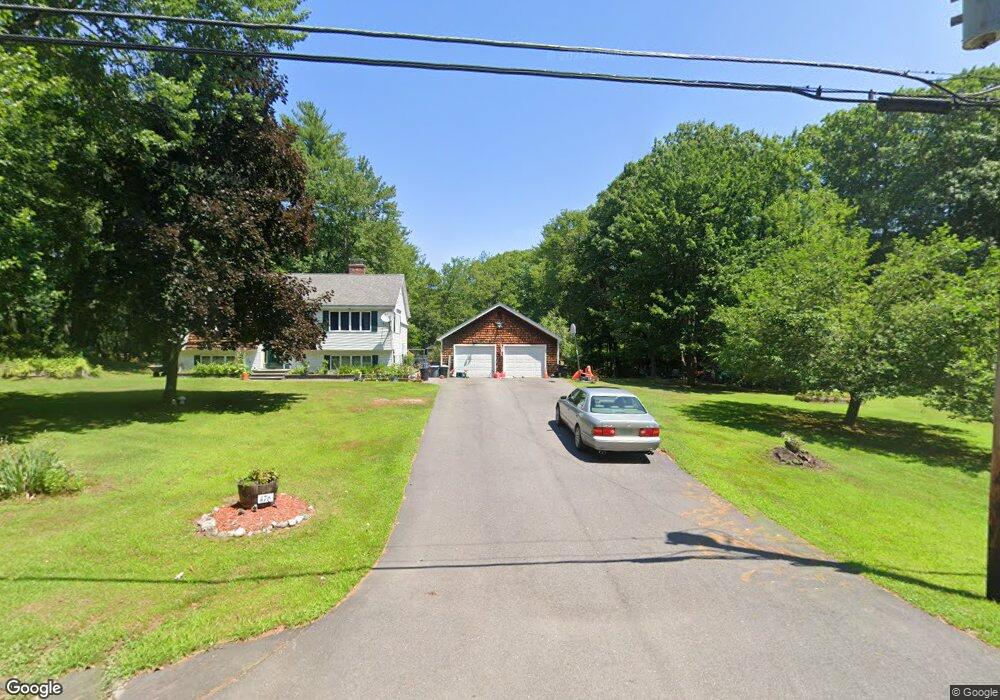
476 2nd Crown Point Rd Strafford, NH 03884
Estimated Value: $431,000 - $496,000
3
Beds
3
Baths
981
Sq Ft
$479/Sq Ft
Est. Value
About This Home
This home is located at 476 2nd Crown Point Rd, Strafford, NH 03884 and is currently estimated at $470,258, approximately $479 per square foot. 476 2nd Crown Point Rd is a home located in Strafford County with nearby schools including Strafford School and Coe-Brown Northwood Academy.
Ownership History
Date
Name
Owned For
Owner Type
Purchase Details
Closed on
Sep 4, 2012
Sold by
Whitcher Mark W and Whitcher Judith L
Bought by
Donald E Kelsey 2Nd Re
Current Estimated Value
Purchase Details
Closed on
Apr 4, 2005
Sold by
Abbott Eria Ann
Bought by
Caron Glenn P
Home Financials for this Owner
Home Financials are based on the most recent Mortgage that was taken out on this home.
Original Mortgage
$191,250
Interest Rate
5.61%
Mortgage Type
Purchase Money Mortgage
Create a Home Valuation Report for This Property
The Home Valuation Report is an in-depth analysis detailing your home's value as well as a comparison with similar homes in the area
Home Values in the Area
Average Home Value in this Area
Purchase History
| Date | Buyer | Sale Price | Title Company |
|---|---|---|---|
| Donald E Kelsey 2Nd Re | $10,000 | -- | |
| Caron Glenn P | $255,000 | -- |
Source: Public Records
Mortgage History
| Date | Status | Borrower | Loan Amount |
|---|---|---|---|
| Previous Owner | Caron Glenn P | $191,250 |
Source: Public Records
Tax History Compared to Growth
Tax History
| Year | Tax Paid | Tax Assessment Tax Assessment Total Assessment is a certain percentage of the fair market value that is determined by local assessors to be the total taxable value of land and additions on the property. | Land | Improvement |
|---|---|---|---|---|
| 2024 | $5,804 | $293,700 | $67,100 | $226,600 |
| 2023 | $5,475 | $293,700 | $67,100 | $226,600 |
| 2022 | $5,031 | $293,700 | $67,100 | $226,600 |
| 2021 | $5,376 | $291,200 | $67,100 | $224,100 |
| 2020 | $5,188 | $202,300 | $61,000 | $141,300 |
| 2019 | $4,748 | $202,300 | $61,000 | $141,300 |
| 2018 | $4,811 | $203,600 | $61,000 | $142,600 |
| 2016 | $4,327 | $203,600 | $61,000 | $142,600 |
| 2015 | $3,956 | $181,400 | $74,900 | $106,500 |
| 2014 | $4,201 | $181,400 | $74,900 | $106,500 |
| 2013 | $3,992 | $176,000 | $74,900 | $101,100 |
| 2012 | $3,939 | $176,000 | $74,900 | $101,100 |
Source: Public Records
Map
Nearby Homes
- 243 Second Crown Point Rd
- 948 Strafford Rd
- 345 Dry Hill Rd
- 86 Long Shores Dr
- 68 Berry River Rd
- 0 Long Shores Dr Unit 5057687
- 83 Sloper Rd
- 0 Sloper Rd Unit 6
- 38 Strafford Rd
- 217-13 Washington St
- 212-0003-01 Washington St
- 207-002 Washington St
- 272 Walnut St
- 10 Blue Hills Dr
- 40 Dry Hill Rd Unit Lot 0250/0006/0000
- 00 Squire Rd
- 8 Juniper Ln
- 395 Greenhill Rd
- 28-1 Range Rd
- 5 Liberty Ln
- 306 Second Crown Point Rd
- 494 2nd Crown Point Rd
- 456 2nd Crown Point Rd
- 497 2nd Crown Point Rd
- 506 2nd Crown Point Rd
- 455 2nd Crown Point Rd
- 199 2nd Crown Point Rd
- 517 2nd Crown Point Rd
- 36 Jennifer Ln
- 38 Jennifer Ln
- 197 2nd Crown Point Rd
- 34 Jennifer Ln
- 426 Second Crown Point Rd
- 426 2nd Crown Point Rd
- 405 2nd Crown Point Rd Unit Lot 30-8
- 405 2nd Crown Point Rd
- 413 2nd Crown Point Rd Unit 30-7
- 427 2nd Crown Point Rd
- 419 2nd Crown Point Rd Unit A
- 419 2nd Crown Point Rd Unit B