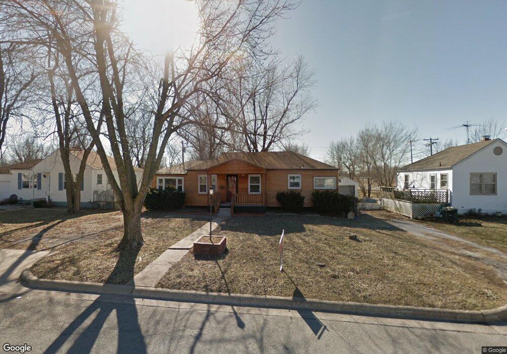
49 Drury Ln Lebanon, MO 65536
Estimated Value: $123,512 - $141,000
3
Beds
1
Bath
1,176
Sq Ft
$114/Sq Ft
Est. Value
About This Home
This home is located at 49 Drury Ln, Lebanon, MO 65536 and is currently estimated at $134,378, approximately $114 per square foot. 49 Drury Ln is a home located in Laclede County with nearby schools including Joe D. Esther Elementary School, Maplecrest Elementary School, and Boswell Elementary School.
Ownership History
Date
Name
Owned For
Owner Type
Purchase Details
Closed on
Mar 26, 2020
Sold by
Felin Cathy M and Cathy M Felin Revocable Living
Bought by
Christiansen Robert and Christiansen Lindsay
Current Estimated Value
Home Financials for this Owner
Home Financials are based on the most recent Mortgage that was taken out on this home.
Original Mortgage
$31,000
Outstanding Balance
$27,462
Interest Rate
3.4%
Mortgage Type
Stand Alone Second
Estimated Equity
$106,916
Create a Home Valuation Report for This Property
The Home Valuation Report is an in-depth analysis detailing your home's value as well as a comparison with similar homes in the area
Home Values in the Area
Average Home Value in this Area
Purchase History
| Date | Buyer | Sale Price | Title Company |
|---|---|---|---|
| Christiansen Robert | -- | None Available |
Source: Public Records
Mortgage History
| Date | Status | Borrower | Loan Amount |
|---|---|---|---|
| Open | Christiansen Robert | $31,000 |
Source: Public Records
Tax History Compared to Growth
Tax History
| Year | Tax Paid | Tax Assessment Tax Assessment Total Assessment is a certain percentage of the fair market value that is determined by local assessors to be the total taxable value of land and additions on the property. | Land | Improvement |
|---|---|---|---|---|
| 2025 | $482 | $9,410 | $0 | $0 |
| 2024 | $482 | $8,460 | $0 | $0 |
| 2023 | $497 | $8,460 | $0 | $0 |
| 2022 | $463 | $8,460 | $0 | $0 |
| 2021 | $510 | $8,455 | $1,444 | $7,011 |
| 2020 | $513 | $8,455 | $1,444 | $7,011 |
| 2019 | $491 | $8,450 | $1,440 | $7,010 |
| 2018 | $461 | $8,450 | $1,440 | $7,010 |
| 2017 | $437 | $8,460 | $0 | $0 |
| 2016 | $437 | $8,460 | $0 | $0 |
| 2015 | $437 | $8,460 | $0 | $0 |
| 2014 | $437 | $8,460 | $0 | $0 |
| 2013 | -- | $8,460 | $0 | $0 |
Source: Public Records
Map
Nearby Homes
- 517 Holly St
- 11 Willow Ln
- 22 Stanwood Dr
- 100 State Highway 32
- 14300 State Highway 32
- 22781 U S Route 66
- 000 #25 U S Route 66
- 000-#72 U S Route 66
- 000#72 U S Route 66
- 000#25 U S Route 66
- 406 Perry St
- 11 Sunrise Dr
- 545 W Pierce St
- 1171 W Elm St
- 757 S Adams Ave
- 1161 Enfield Dr
- 853 W Park Manor Blvd
- 704 W 2nd St
- 225 Garfield St
- 000 U S Route 66