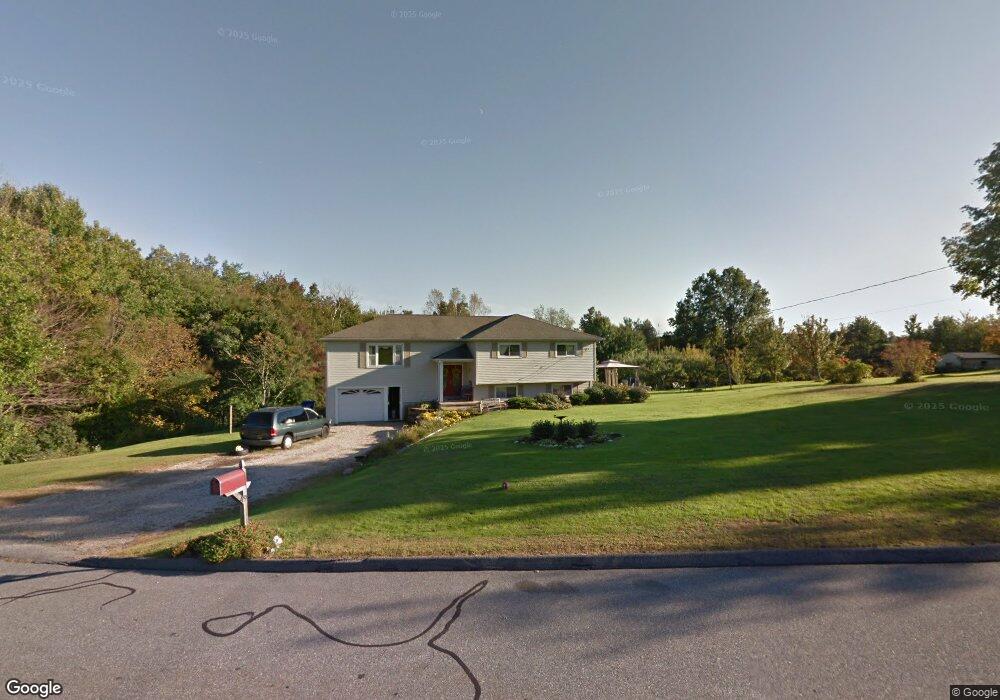
49 Silo Dr Harwinton, CT 06791
Estimated Value: $438,000 - $533,000
4
Beds
3
Baths
1,620
Sq Ft
$292/Sq Ft
Est. Value
About This Home
This home is located at 49 Silo Dr, Harwinton, CT 06791 and is currently estimated at $473,841, approximately $292 per square foot. 49 Silo Dr is a home located in Litchfield County with nearby schools including Harwinton Consolidated School, Har-Bur Middle School, and Lewis S. Mills High School.
Ownership History
Date
Name
Owned For
Owner Type
Purchase Details
Closed on
Mar 7, 2003
Sold by
Ouellette Eric J
Bought by
Nordstrom Marc A and Nordstrom Michelle A
Current Estimated Value
Home Financials for this Owner
Home Financials are based on the most recent Mortgage that was taken out on this home.
Original Mortgage
$251,250
Interest Rate
5.95%
Mortgage Type
VA
Purchase Details
Closed on
Jun 24, 1996
Sold by
Holmes Roger A and Holmes Elaine J
Bought by
Ouellette Eric J
Create a Home Valuation Report for This Property
The Home Valuation Report is an in-depth analysis detailing your home's value as well as a comparison with similar homes in the area
Home Values in the Area
Average Home Value in this Area
Purchase History
| Date | Buyer | Sale Price | Title Company |
|---|---|---|---|
| Nordstrom Marc A | $255,000 | -- | |
| Nordstrom Marc A | $255,000 | -- | |
| Ouellette Eric J | $122,000 | -- | |
| Ouellette Eric J | $122,000 | -- |
Source: Public Records
Mortgage History
| Date | Status | Borrower | Loan Amount |
|---|---|---|---|
| Open | Ouellette Eric J | $223,128 | |
| Closed | Ouellette Eric J | $251,250 |
Source: Public Records
Tax History Compared to Growth
Tax History
| Year | Tax Paid | Tax Assessment Tax Assessment Total Assessment is a certain percentage of the fair market value that is determined by local assessors to be the total taxable value of land and additions on the property. | Land | Improvement |
|---|---|---|---|---|
| 2025 | $5,832 | $253,570 | $69,580 | $183,990 |
| 2024 | $5,807 | $253,570 | $69,580 | $183,990 |
| 2023 | $6,114 | $209,400 | $49,700 | $159,700 |
| 2022 | $5,968 | $209,400 | $49,700 | $159,700 |
| 2021 | $6,010 | $209,400 | $49,700 | $159,700 |
| 2020 | $5,863 | $209,400 | $49,700 | $159,700 |
| 2019 | $5,863 | $209,400 | $49,700 | $159,700 |
| 2018 | $5,970 | $213,230 | $62,160 | $151,070 |
| 2017 | $5,928 | $213,230 | $62,160 | $151,070 |
| 2016 | $5,928 | $213,230 | $62,160 | $151,070 |
| 2015 | $5,821 | $213,230 | $62,160 | $151,070 |
| 2014 | $5,736 | $213,230 | $62,160 | $151,070 |
Source: Public Records
Map
Nearby Homes
- 92 Shafer Rd
- 175 Ramstein Rd
- 164 Birge Park Rd
- 195 County Line Rd
- 73 Shirley Rd
- 21 South Rd
- 74 Pine Ridge Dr
- 37 Hidden Hill Rd
- 51 Bradford Rd
- 111 Oxbow Dr
- 29 Partridge Ln
- 65 Oak Meadow Ln Unit 65
- 1480 Litchfield Turnpike
- 21 Oak Meadow Ln
- 1526 Litchfield Turnpike
- 28 Lily Pond Rd
- 595 Torringford St
- 714 Torringford St
- 325 Circle Dr
- 410 Circle Dr