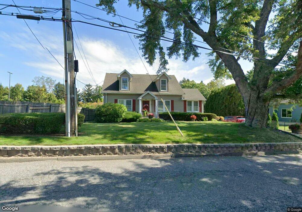
494 Whitney Ave Holyoke, MA 01040
Estimated Value: $320,938 - $355,000
3
Beds
2
Baths
1,657
Sq Ft
$201/Sq Ft
Est. Value
About This Home
This home is located at 494 Whitney Ave, Holyoke, MA 01040 and is currently estimated at $332,485, approximately $200 per square foot. 494 Whitney Ave is a home located in Hampden County with nearby schools including Butterfield Elementary School, Maurice A. Donahue Elementary School, and Holyoke High School.
Ownership History
Date
Name
Owned For
Owner Type
Purchase Details
Closed on
Aug 20, 2020
Sold by
Britton Roy A and Britton Donna M
Bought by
Donna M Britton Irt
Current Estimated Value
Purchase Details
Closed on
Jun 1, 1971
Bought by
Britton Roy A and Britton Donna M
Create a Home Valuation Report for This Property
The Home Valuation Report is an in-depth analysis detailing your home's value as well as a comparison with similar homes in the area
Home Values in the Area
Average Home Value in this Area
Purchase History
| Date | Buyer | Sale Price | Title Company |
|---|---|---|---|
| Donna M Britton Irt | -- | None Available | |
| Britton Roy A | -- | -- |
Source: Public Records
Mortgage History
| Date | Status | Borrower | Loan Amount |
|---|---|---|---|
| Previous Owner | Britton Roy A | $40,000 | |
| Previous Owner | Britton Roy A | $40,000 |
Source: Public Records
Tax History Compared to Growth
Tax History
| Year | Tax Paid | Tax Assessment Tax Assessment Total Assessment is a certain percentage of the fair market value that is determined by local assessors to be the total taxable value of land and additions on the property. | Land | Improvement |
|---|---|---|---|---|
| 2025 | $4,246 | $243,200 | $48,800 | $194,400 |
| 2024 | $4,046 | $213,500 | $46,300 | $167,200 |
| 2023 | $3,866 | $206,100 | $46,300 | $159,800 |
| 2022 | $3,731 | $193,700 | $46,300 | $147,400 |
| 2021 | $3,557 | $184,600 | $44,900 | $139,700 |
| 2020 | $3,371 | $176,700 | $44,900 | $131,800 |
| 2019 | $3,362 | $174,300 | $44,900 | $129,400 |
| 2018 | $3,206 | $167,600 | $44,900 | $122,700 |
| 2017 | $3,217 | $167,800 | $44,900 | $122,900 |
| 2016 | $3,174 | $166,000 | $46,300 | $119,700 |
| 2015 | $3,161 | $166,000 | $46,300 | $119,700 |
Source: Public Records
Map
Nearby Homes
- 89-111 Whitney Ave
- 39 Bonnie Brae Dr
- 50 Overlook Dr
- 59 Clayton Dr
- lot b Homestead Ave
- 212 Poplar St
- 86 Beaumont Ave
- 11 Annie's Way
- 51 Beaumont Ave
- 87 Blanchwood Ave
- 81 Poplar St
- 54 Dayton St
- 90 Mckinstry Ave Unit 117
- 71 Florence St
- 66 Wayfield Ave
- 53 Farnum Dr Unit 53
- 76 Roy St
- 39 Daley St
- 24 Daley St
- 80 Brush Hill Ave Unit 28
- 496 Whitney Ave
- 507-517 Whitney Ave
- 507 Whitney Ave
- 507 Whitney Ave
- 106 Whitney Ave
- 5 Gamelin St
- 22 Whitney Ave Unit 24
- 22 Whitney Ave
- 187 Highland Ave
- 163 Highland Ave
- 112 Highland Ave
- 141 Highland Ave
- 173 Highland Ave
- 102 Highland Ave Unit 104
- 204 Bonnie Brae Dr
- 133 Highland Ave
- 119 Highland Ave
- 212 Bonnie Brae Dr
- 107 Highland Ave
- 173 Bonnie Brae Dr