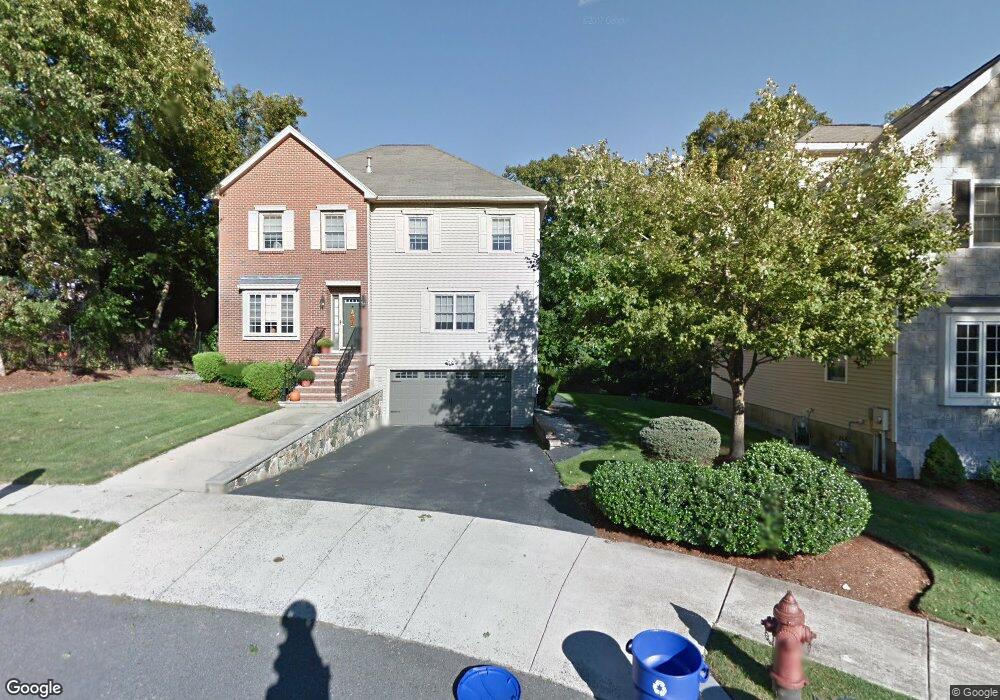
5 Mardin Ln Stoneham, MA 02180
Colonial Park NeighborhoodEstimated Value: $1,150,000 - $1,303,000
5
Beds
4
Baths
3,000
Sq Ft
$409/Sq Ft
Est. Value
About This Home
This home is located at 5 Mardin Ln, Stoneham, MA 02180 and is currently estimated at $1,227,998, approximately $409 per square foot. 5 Mardin Ln is a home located in Middlesex County with nearby schools including Stoneham High School, St. Patrick Elementary School, and Melrose Montessori School.
Ownership History
Date
Name
Owned For
Owner Type
Purchase Details
Closed on
Nov 20, 2006
Sold by
Prizio Kathleen M and Prizio Peter N
Bought by
Ellis Christopher T and Ellis Susan M
Current Estimated Value
Home Financials for this Owner
Home Financials are based on the most recent Mortgage that was taken out on this home.
Original Mortgage
$370,000
Interest Rate
6.33%
Mortgage Type
Purchase Money Mortgage
Purchase Details
Closed on
Sep 4, 1998
Sold by
Stoneham Oak Hill Nt and Houghton
Bought by
Prizio Peter N and Prizio Kathleen M
Home Financials for this Owner
Home Financials are based on the most recent Mortgage that was taken out on this home.
Original Mortgage
$296,000
Interest Rate
6.9%
Mortgage Type
Purchase Money Mortgage
Create a Home Valuation Report for This Property
The Home Valuation Report is an in-depth analysis detailing your home's value as well as a comparison with similar homes in the area
Home Values in the Area
Average Home Value in this Area
Purchase History
| Date | Buyer | Sale Price | Title Company |
|---|---|---|---|
| Ellis Christopher T | $620,000 | -- | |
| Ellis Christopher T | $620,000 | -- | |
| Prizio Peter N | $370,000 | -- |
Source: Public Records
Mortgage History
| Date | Status | Borrower | Loan Amount |
|---|---|---|---|
| Open | Prizio Peter N | $342,500 | |
| Closed | Prizio Peter N | $360,000 | |
| Closed | Ellis Christopher T | $370,000 | |
| Previous Owner | Prizio Peter N | $296,000 |
Source: Public Records
Tax History Compared to Growth
Tax History
| Year | Tax Paid | Tax Assessment Tax Assessment Total Assessment is a certain percentage of the fair market value that is determined by local assessors to be the total taxable value of land and additions on the property. | Land | Improvement |
|---|---|---|---|---|
| 2025 | $10,162 | $993,400 | $400,400 | $593,000 |
| 2024 | $9,714 | $917,300 | $370,400 | $546,900 |
| 2023 | $9,389 | $845,900 | $340,400 | $505,500 |
| 2022 | $8,291 | $796,400 | $320,400 | $476,000 |
| 2021 | $8,310 | $768,000 | $300,400 | $467,600 |
| 2020 | $8,244 | $764,000 | $300,400 | $463,600 |
| 2019 | $8,191 | $730,000 | $270,400 | $459,600 |
| 2018 | $7,919 | $676,300 | $250,400 | $425,900 |
| 2017 | $8,175 | $659,800 | $240,400 | $419,400 |
| 2016 | $7,880 | $620,500 | $230,400 | $390,100 |
| 2015 | $7,876 | $607,700 | $230,400 | $377,300 |
| 2014 | $7,921 | $587,200 | $220,400 | $366,800 |
Source: Public Records
Map
Nearby Homes
- 14 Dinanno Rd
- 39 Tamarock Terrace
- 81 Spring St
- 1 Ludlow Ave
- 6 Gavin Cir
- 4 Gavin Cir
- 6 Lovis Ave
- 9 Lovis Ave
- 159 Franklin St Unit C2
- 17 Franklin St
- 5 Sheffield Rd
- 137 Franklin St Unit 102
- 137 Franklin St Unit 404
- 61 Forest St
- 3 Hickory Hill Rd Unit 1
- 24 Myrtle Ave
- 569 Franklin St Unit 1
- 569 Franklin St Unit 3
- 2 Overlook Rd
- 20 Myrtle St