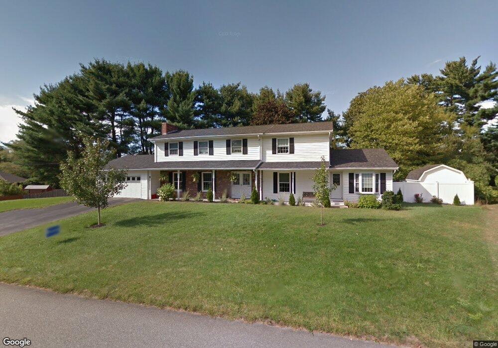
5 Sherwood Cir Salem, NH 03079
Salem Center NeighborhoodEstimated Value: $721,000 - $880,000
4
Beds
5
Baths
3,068
Sq Ft
$256/Sq Ft
Est. Value
About This Home
This home is located at 5 Sherwood Cir, Salem, NH 03079 and is currently estimated at $786,336, approximately $256 per square foot. 5 Sherwood Cir is a home located in Rockingham County with nearby schools including William T. Barron Elementary School, Woodbury School, and Salem High School.
Ownership History
Date
Name
Owned For
Owner Type
Purchase Details
Closed on
Apr 2, 2013
Sold by
Burns Thomas C
Bought by
Burns Thomas C and Burns Laurie B
Current Estimated Value
Home Financials for this Owner
Home Financials are based on the most recent Mortgage that was taken out on this home.
Original Mortgage
$196,000
Outstanding Balance
$138,912
Interest Rate
3.56%
Mortgage Type
New Conventional
Estimated Equity
$647,424
Purchase Details
Closed on
May 3, 2006
Sold by
Burns James W
Bought by
Burns James W and Burns Thomas C
Home Financials for this Owner
Home Financials are based on the most recent Mortgage that was taken out on this home.
Original Mortgage
$181,700
Interest Rate
6.62%
Mortgage Type
Unknown
Create a Home Valuation Report for This Property
The Home Valuation Report is an in-depth analysis detailing your home's value as well as a comparison with similar homes in the area
Home Values in the Area
Average Home Value in this Area
Purchase History
| Date | Buyer | Sale Price | Title Company |
|---|---|---|---|
| Burns Thomas C | -- | -- | |
| Burns James W | $87,500 | -- |
Source: Public Records
Mortgage History
| Date | Status | Borrower | Loan Amount |
|---|---|---|---|
| Open | Burns Thomas C | $196,000 | |
| Closed | Burns Thomas C | $100,000 | |
| Previous Owner | Burns James W | $100,000 | |
| Previous Owner | Burns James W | $216,500 | |
| Previous Owner | Burns James W | $181,700 |
Source: Public Records
Tax History Compared to Growth
Tax History
| Year | Tax Paid | Tax Assessment Tax Assessment Total Assessment is a certain percentage of the fair market value that is determined by local assessors to be the total taxable value of land and additions on the property. | Land | Improvement |
|---|---|---|---|---|
| 2024 | $10,058 | $571,500 | $175,800 | $395,700 |
| 2023 | $9,693 | $571,500 | $175,800 | $395,700 |
| 2022 | $9,173 | $571,500 | $175,800 | $395,700 |
| 2021 | $9,133 | $571,500 | $175,800 | $395,700 |
| 2020 | $9,211 | $418,300 | $125,600 | $292,700 |
| 2019 | $9,194 | $418,300 | $125,600 | $292,700 |
| 2018 | $9,039 | $418,300 | $125,600 | $292,700 |
| 2017 | $9,040 | $433,800 | $125,600 | $308,200 |
| 2016 | $8,863 | $433,800 | $125,600 | $308,200 |
| 2015 | $8,041 | $375,900 | $125,400 | $250,500 |
| 2014 | $7,815 | $375,900 | $125,400 | $250,500 |
| 2013 | $7,691 | $375,900 | $125,400 | $250,500 |
Source: Public Records
Map
Nearby Homes
- 6 Douglas Dr
- 20 Stanwood Rd
- 40 Stanwood Rd Unit 9
- 1 Kimball Ave
- 1 Ballard Ln
- 10 Sally Sweets Way Unit V104
- 27 General Pulaski Dr
- 139 North St
- 8 Alta Ave
- 74 Ayers Village Rd
- 20 Ashwood Ave
- 1513 Broadway
- 4 Therriault Ave
- 35 Fraser Dr
- 55A Millville Cir
- 51 Bluff St
- 17 Sawmill Ridge Rd
- 12 Braemoor Woods Rd Unit 206
- 49 Millville St
- 89 End St