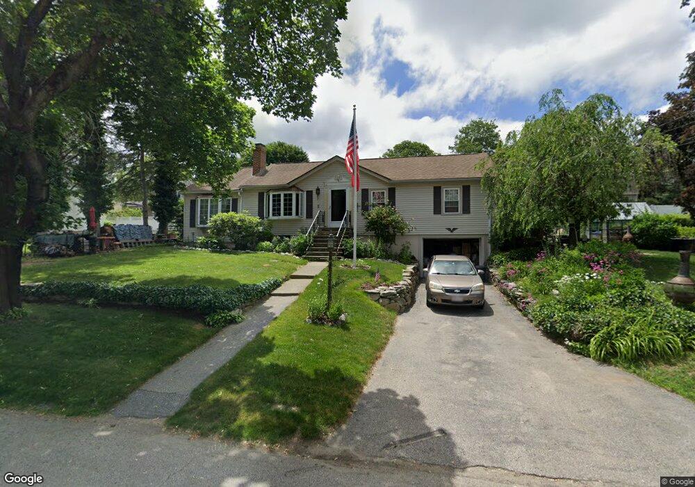
5 Shore Dr North Grafton, MA 01536
Estimated Value: $430,000 - $495,855
2
Beds
1
Bath
1,032
Sq Ft
$445/Sq Ft
Est. Value
About This Home
This home is located at 5 Shore Dr, North Grafton, MA 01536 and is currently estimated at $459,214, approximately $444 per square foot. 5 Shore Dr is a home located in Worcester County with nearby schools including Grafton High School, St Stephen Elementary School, and Al-Hamra Academy.
Ownership History
Date
Name
Owned For
Owner Type
Purchase Details
Closed on
Nov 5, 2001
Sold by
Arsenault P Est
Bought by
Arsenault Amy Jo and Dow Deborah L
Current Estimated Value
Home Financials for this Owner
Home Financials are based on the most recent Mortgage that was taken out on this home.
Original Mortgage
$78,000
Outstanding Balance
$30,711
Interest Rate
6.82%
Mortgage Type
Purchase Money Mortgage
Estimated Equity
$428,503
Create a Home Valuation Report for This Property
The Home Valuation Report is an in-depth analysis detailing your home's value as well as a comparison with similar homes in the area
Home Values in the Area
Average Home Value in this Area
Purchase History
| Date | Buyer | Sale Price | Title Company |
|---|---|---|---|
| Arsenault Amy Jo | $107,500 | -- | |
| Arsenault Amy Jo | $107,500 | -- |
Source: Public Records
Mortgage History
| Date | Status | Borrower | Loan Amount |
|---|---|---|---|
| Open | Arsenault Amy Jo | $78,000 | |
| Closed | Arsenault Amy Jo | $78,000 | |
| Previous Owner | Arsenault Amy Jo | $15,500 |
Source: Public Records
Tax History Compared to Growth
Tax History
| Year | Tax Paid | Tax Assessment Tax Assessment Total Assessment is a certain percentage of the fair market value that is determined by local assessors to be the total taxable value of land and additions on the property. | Land | Improvement |
|---|---|---|---|---|
| 2025 | $5,410 | $388,100 | $173,000 | $215,100 |
| 2024 | $5,288 | $369,500 | $164,800 | $204,700 |
| 2023 | $5,156 | $328,200 | $164,800 | $163,400 |
| 2022 | $4,836 | $286,500 | $141,500 | $145,000 |
| 2021 | $5,128 | $298,500 | $128,600 | $169,900 |
| 2020 | $4,859 | $294,500 | $128,600 | $165,900 |
| 2019 | $4,610 | $276,700 | $124,900 | $151,800 |
| 2018 | $4,373 | $263,600 | $124,200 | $139,400 |
| 2017 | $4,203 | $256,300 | $116,900 | $139,400 |
| 2016 | $3,827 | $228,500 | $93,900 | $134,600 |
| 2015 | $3,772 | $228,600 | $92,800 | $135,800 |
| 2014 | $3,583 | $234,800 | $109,600 | $125,200 |
Source: Public Records
Map
Nearby Homes
- 11 Hovey Pond Dr Unit 11
- 194 Worcester St
- 14 Northgate Ct Unit 14
- 17 Hingham Rd
- 4 Westboro Rd
- 30 Falmouth Dr
- 15 Windle Ave
- 69 Cortland Grove Dr Unit 69
- 76 Samuel Dr
- 44 Meadow Ln
- 21 Lordvale Blvd Unit 406
- 0 East St
- 51 Cortland Grove Dr Unit 51
- 39 Pointe Rok Dr Unit 39
- 5 Lincoln Ln Unit 5
- 4 Winslow Ln Unit 1410
- 1 Purinton St
- 95 Pineland Ave
- 46 John Dr Unit 46
- 28 Lincoln Ln