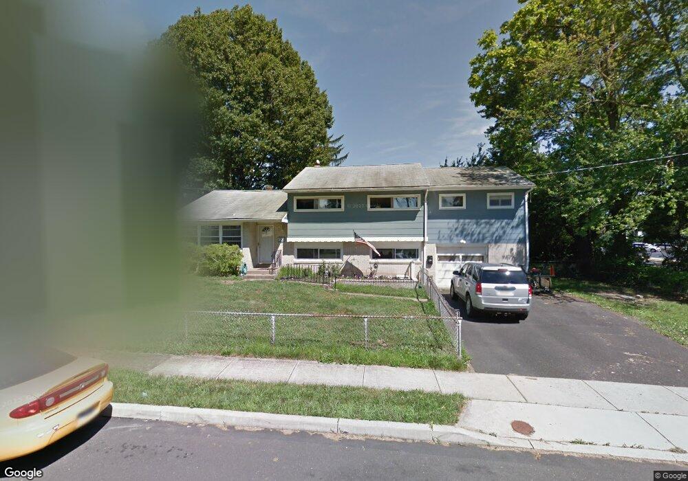
501 Curtis Dr Morrisville, PA 19067
Estimated Value: $486,000 - $562,000
4
Beds
2
Baths
1,603
Sq Ft
$324/Sq Ft
Est. Value
About This Home
This home is located at 501 Curtis Dr, Morrisville, PA 19067 and is currently estimated at $518,605, approximately $323 per square foot. 501 Curtis Dr is a home located in Bucks County with nearby schools including Eleanor Roosevelt Elementary School, Pennwood Middle School, and Pennsbury High School.
Ownership History
Date
Name
Owned For
Owner Type
Purchase Details
Closed on
Jul 7, 2006
Sold by
Canham Norman
Bought by
Birnbrauer Robert and Birnbrauer Christine M
Current Estimated Value
Home Financials for this Owner
Home Financials are based on the most recent Mortgage that was taken out on this home.
Original Mortgage
$85,200
Outstanding Balance
$50,637
Interest Rate
6.67%
Mortgage Type
Credit Line Revolving
Estimated Equity
$467,968
Create a Home Valuation Report for This Property
The Home Valuation Report is an in-depth analysis detailing your home's value as well as a comparison with similar homes in the area
Home Values in the Area
Average Home Value in this Area
Purchase History
| Date | Buyer | Sale Price | Title Company |
|---|---|---|---|
| Birnbrauer Robert | $296,000 | None Available |
Source: Public Records
Mortgage History
| Date | Status | Borrower | Loan Amount |
|---|---|---|---|
| Open | Birnbrauer Robert | $85,200 | |
| Open | Birnbrauer Robert | $196,000 |
Source: Public Records
Tax History Compared to Growth
Tax History
| Year | Tax Paid | Tax Assessment Tax Assessment Total Assessment is a certain percentage of the fair market value that is determined by local assessors to be the total taxable value of land and additions on the property. | Land | Improvement |
|---|---|---|---|---|
| 2025 | $6,414 | $28,800 | $5,840 | $22,960 |
| 2024 | $6,414 | $28,800 | $5,840 | $22,960 |
| 2023 | $6,145 | $28,800 | $5,840 | $22,960 |
| 2022 | $5,954 | $28,800 | $5,840 | $22,960 |
| 2021 | $5,839 | $28,800 | $5,840 | $22,960 |
| 2020 | $5,839 | $28,800 | $5,840 | $22,960 |
| 2019 | $5,737 | $28,800 | $5,840 | $22,960 |
| 2018 | $5,666 | $28,800 | $5,840 | $22,960 |
| 2017 | $5,523 | $28,800 | $5,840 | $22,960 |
| 2016 | $5,523 | $28,800 | $5,840 | $22,960 |
| 2015 | $5,295 | $28,800 | $5,840 | $22,960 |
| 2014 | $5,295 | $28,800 | $5,840 | $22,960 |
Source: Public Records
Map
Nearby Homes
- 413 Alden Ave
- 404 Alden Ave
- 211 Valley Rd
- 494 Keating Dr
- 113 Juliet Rd
- 209 Alden Ave
- 113 Penns Grant Dr
- 115 Winding Way
- 5 Patrick Ln
- 581 Nottingham Dr
- 320 Melvin Ave N
- 329 Sherwood Dr
- 227 W Ferry Rd
- 79 Sutphin Pines
- 505 Carmela Way
- 21 Lynns Ct
- 9 Lynns Ct
- LOT 021-003 W M Y Ln
- 51 Sutphin Pines
- 5 Sutphin Pines