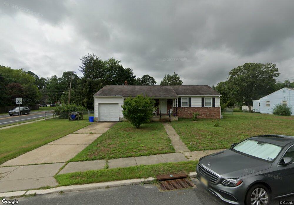
501 Pierce Ave Linwood, NJ 08221
Estimated Value: $285,042 - $399,000
--
Bed
--
Bath
1,120
Sq Ft
$316/Sq Ft
Est. Value
About This Home
This home is located at 501 Pierce Ave, Linwood, NJ 08221 and is currently estimated at $353,681, approximately $315 per square foot. 501 Pierce Ave is a home located in Atlantic County with nearby schools including Seaview Elementary School, Belhaven Middle School, and Mainland Regional High School.
Ownership History
Date
Name
Owned For
Owner Type
Purchase Details
Closed on
Nov 14, 2014
Sold by
Henderson Dennis J and Henderson Stanislava
Bought by
Henderson Dennis J and Henderson Stanislava
Current Estimated Value
Home Financials for this Owner
Home Financials are based on the most recent Mortgage that was taken out on this home.
Original Mortgage
$171,920
Outstanding Balance
$129,975
Interest Rate
3.65%
Mortgage Type
New Conventional
Estimated Equity
$223,706
Purchase Details
Closed on
Sep 20, 1991
Sold by
Fipp Warren
Bought by
Henderson Dennis J
Create a Home Valuation Report for This Property
The Home Valuation Report is an in-depth analysis detailing your home's value as well as a comparison with similar homes in the area
Home Values in the Area
Average Home Value in this Area
Purchase History
| Date | Buyer | Sale Price | Title Company |
|---|---|---|---|
| Henderson Dennis J | -- | Servicelink | |
| Henderson Dennis J | $111,500 | -- |
Source: Public Records
Mortgage History
| Date | Status | Borrower | Loan Amount |
|---|---|---|---|
| Open | Henderson Dennis J | $171,920 |
Source: Public Records
Tax History Compared to Growth
Tax History
| Year | Tax Paid | Tax Assessment Tax Assessment Total Assessment is a certain percentage of the fair market value that is determined by local assessors to be the total taxable value of land and additions on the property. | Land | Improvement |
|---|---|---|---|---|
| 2025 | $5,505 | $144,300 | $85,500 | $58,800 |
| 2024 | $5,505 | $144,300 | $85,500 | $58,800 |
| 2023 | $5,250 | $144,300 | $85,500 | $58,800 |
| 2022 | $5,250 | $144,300 | $85,500 | $58,800 |
| 2021 | $5,203 | $144,300 | $85,500 | $58,800 |
| 2020 | $5,131 | $144,300 | $85,500 | $58,800 |
| 2019 | $5,022 | $144,300 | $85,500 | $58,800 |
| 2018 | $4,909 | $144,300 | $85,500 | $58,800 |
| 2017 | $5,998 | $179,900 | $94,000 | $85,900 |
| 2016 | $5,796 | $179,900 | $94,000 | $85,900 |
| 2015 | $5,802 | $179,900 | $94,000 | $85,900 |
| 2014 | $5,577 | $179,900 | $94,000 | $85,900 |
Source: Public Records
Map
Nearby Homes
- 901 Oak Ave
- 1005 Bartlett Ave
- 1026 Bartlett Dr
- 1026 Bartlett Ave
- 500 Davis Ave
- 921 Oak Grove Ave
- 2 Sandy Ct
- 309 Haines Ave
- 104 W Poplar Ave
- 15 Elm Ave
- 109 Blackman Rd
- 130 Wilson Ave
- 210 Haines Ave
- 34 Crossing Dr
- 404 Cedarbrook Ln
- 120 W Devonshire Ave
- 28 Crossing Dr
- 1050 Shore Rd
- 622 Central Ave
- 4 Princeton Ln
- 503 Pierce Ave
- 502 Van Sant Ave
- 500 Pierce Ave
- 502 Pierce Ave
- 505 Pierce Ave
- 418 Van Sant Ave
- 504 Van Sant Ave
- 501 Marie Ave
- 501 Van Sant Ave
- 504 Pierce Ave
- 1000 Richards Dr
- 503 Marie Ave
- 425 Van Sant Ave
- 507 Pierce Ave
- 506 Van Sant Ave
- 505 Marie Ave
- 506 Pierce Ave
- 1003 New Rd
- 1001 Richards Dr
- 1002 Richards Dr