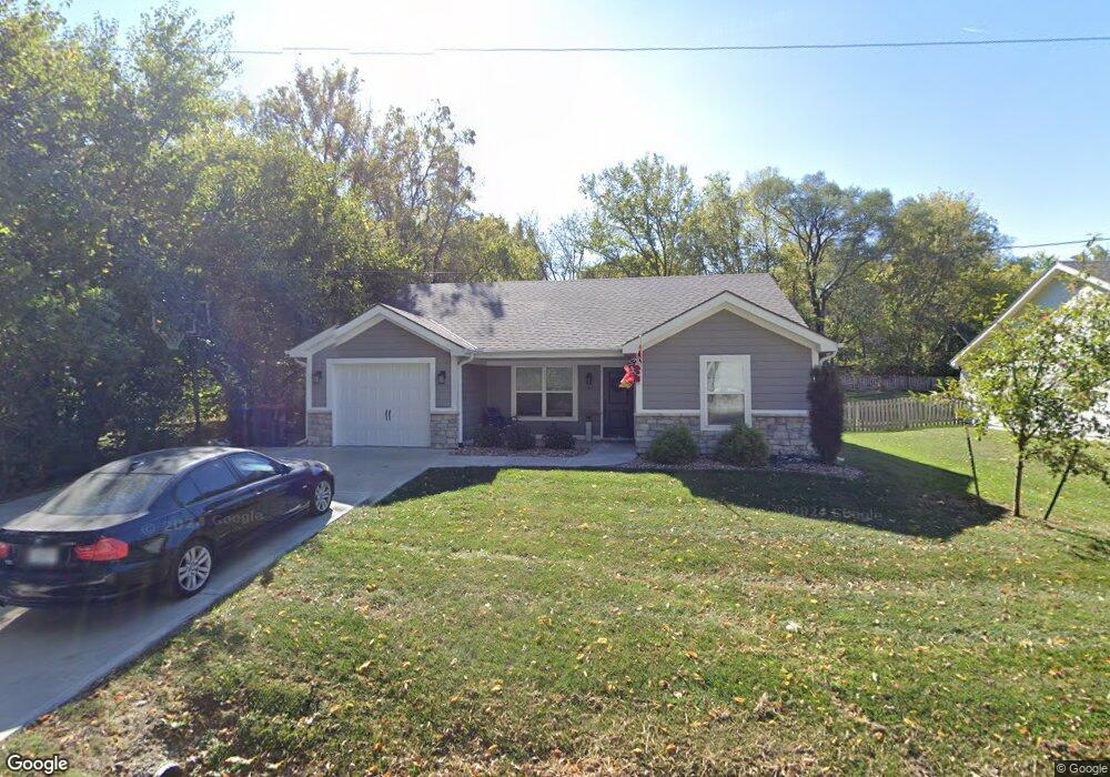
507 Walnut St Greenwood, MO 64034
Estimated Value: $281,000 - $407,000
2
Beds
2
Baths
1,380
Sq Ft
$241/Sq Ft
Est. Value
About This Home
This home is located at 507 Walnut St, Greenwood, MO 64034 and is currently estimated at $332,241, approximately $240 per square foot. 507 Walnut St is a home located in Jackson County with nearby schools including Greenwood Elementary School, Summit Lakes Middle School, and Lee's Summit West High School.
Ownership History
Date
Name
Owned For
Owner Type
Purchase Details
Closed on
Jun 26, 2025
Sold by
Hertzog Todd James and Hertzog Ashley
Bought by
Big Creek Investments Llc
Current Estimated Value
Purchase Details
Closed on
Mar 17, 2021
Sold by
Pfeifer Homes Inc
Bought by
Asset Exchange Llc
Purchase Details
Closed on
Dec 5, 2002
Sold by
Edwards Gerald J
Bought by
Ranville Properties Management Llc
Purchase Details
Closed on
Jun 22, 1998
Sold by
Vaughn Bricker Velma
Bought by
Vaughn Velma Bricker and Velma Bricker Vaughn Trust
Create a Home Valuation Report for This Property
The Home Valuation Report is an in-depth analysis detailing your home's value as well as a comparison with similar homes in the area
Home Values in the Area
Average Home Value in this Area
Purchase History
| Date | Buyer | Sale Price | Title Company |
|---|---|---|---|
| Big Creek Investments Llc | -- | None Listed On Document | |
| Asset Exchange Llc | -- | Coffelt Land Title Inc | |
| Ranville Properties Management Llc | -- | -- | |
| Vaughn Velma Bricker | -- | -- |
Source: Public Records
Tax History Compared to Growth
Tax History
| Year | Tax Paid | Tax Assessment Tax Assessment Total Assessment is a certain percentage of the fair market value that is determined by local assessors to be the total taxable value of land and additions on the property. | Land | Improvement |
|---|---|---|---|---|
| 2025 | $2,903 | $47,616 | $5,140 | $42,476 |
| 2024 | $2,903 | $41,990 | $3,325 | $38,665 |
| 2023 | $2,874 | $41,990 | $2,109 | $39,881 |
| 2022 | $2,798 | $36,005 | $2,280 | $33,725 |
| 2021 | $181 | $2,280 | $2,280 | $0 |
| 2020 | $184 | $2,280 | $2,280 | $0 |
| 2019 | $302 | $3,800 | $3,800 | $0 |
| 2018 | $169 | $1,966 | $1,966 | $0 |
| 2017 | $169 | $1,966 | $1,966 | $0 |
| 2016 | $169 | $1,917 | $1,917 | $0 |
| 2014 | $173 | $1,917 | $1,917 | $0 |
Source: Public Records
Map
Nearby Homes
- 202 6th Ave S
- 1106 Huntington Ln
- 1107 Huntington Ln
- 1210 Huntington Ln
- 1301 Meadows Ln
- 1113 Hummingbird Ct
- 403 Ridgeway Dr
- 701 16th Ave S
- 105 17th Ave S
- 405 17th Ave S
- 704 16th Ave S
- 810 Tabitha Ln
- 1505 Rolling Dr
- 1104 16th Ave S
- 1306 Dogwood Dr
- 1011 Wilds Pkwy
- 1803 Brent Ln
- 1010 Wilds Pkwy
- 1900 Blackfoot Ct
- 512 Wilds Pkwy