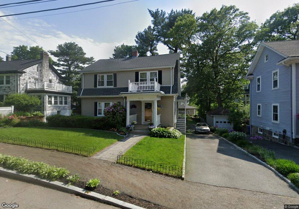
510 Eliot St Milton, MA 02186
Columbine Cliffs NeighborhoodEstimated Value: $940,000 - $1,057,000
4
Beds
2
Baths
1,873
Sq Ft
$533/Sq Ft
Est. Value
About This Home
This home is located at 510 Eliot St, Milton, MA 02186 and is currently estimated at $997,853, approximately $532 per square foot. 510 Eliot St is a home located in Norfolk County with nearby schools including Milton High School, KIPP Academy Boston Charter School, and St. Mary of the Hills School.
Ownership History
Date
Name
Owned For
Owner Type
Purchase Details
Closed on
Jul 6, 2018
Sold by
Dillard Rickie and Dillard Ruth M
Bought by
510 Eliot Street Rt
Current Estimated Value
Purchase Details
Closed on
Jun 6, 1988
Sold by
Wallace Edwin L
Bought by
Dillard Rickie
Create a Home Valuation Report for This Property
The Home Valuation Report is an in-depth analysis detailing your home's value as well as a comparison with similar homes in the area
Home Values in the Area
Average Home Value in this Area
Purchase History
| Date | Buyer | Sale Price | Title Company |
|---|---|---|---|
| 510 Eliot Street Rt | -- | -- | |
| Dillard Rickie | $232,000 | -- |
Source: Public Records
Mortgage History
| Date | Status | Borrower | Loan Amount |
|---|---|---|---|
| Previous Owner | Dillard Rickie | $75,000 | |
| Previous Owner | Dillard Rickie | $200,000 |
Source: Public Records
Tax History Compared to Growth
Tax History
| Year | Tax Paid | Tax Assessment Tax Assessment Total Assessment is a certain percentage of the fair market value that is determined by local assessors to be the total taxable value of land and additions on the property. | Land | Improvement |
|---|---|---|---|---|
| 2025 | $9,181 | $827,900 | $444,300 | $383,600 |
| 2024 | $8,928 | $817,600 | $423,200 | $394,400 |
| 2023 | $8,894 | $780,200 | $403,200 | $377,000 |
| 2022 | $8,684 | $696,400 | $403,200 | $293,200 |
| 2021 | $8,339 | $635,100 | $355,900 | $279,200 |
| 2020 | $8,052 | $613,700 | $341,000 | $272,700 |
| 2019 | $7,854 | $595,900 | $331,100 | $264,800 |
| 2018 | $7,457 | $540,000 | $278,100 | $261,900 |
| 2017 | $6,975 | $514,400 | $264,900 | $249,500 |
| 2016 | $7,582 | $561,600 | $317,800 | $243,800 |
| 2015 | $7,454 | $534,700 | $296,700 | $238,000 |
Source: Public Records
Map
Nearby Homes
- 27 Hawthorn Rd
- 15 Fairfax Rd
- 214 Brook Rd
- 84 Blue Hills Pkwy
- 128 Blue Hills Pkwy
- 16 Blue Hill Ave
- 32 Columbine Rd
- 96 Brook Rd
- 137 Thacher St Unit 137
- 333 Eliot St
- 96 Houston Ave
- 48-50 Rockdale St
- 15 Cantwell Rd
- 112 Brush Hill Rd
- 70 Warren Ave
- 10 Briarcliff Terrace
- 645 River St
- 24 Constitution Rd
- 1 Chilton Park
- 90 Hollingsworth St
- 514 Eliot St
- 506 Eliot St
- 520 Eliot St
- 16 Hawthorn Rd
- 18 Hawthorn Rd
- 18 Hawthorn Rd Unit 2
- 22 Hawthorn Rd
- 500 Eliot St
- 12 Hawthorn Rd
- 12 Virginia St Unit 14
- 12 Virginia St
- 12 Virginia St Unit 1
- 12 Virginia St Unit 12 Virginia Street M
- 10 Cliff Rd
- 26 Hawthorn Rd
- 12-14 Virginia St Unit 1
- 524 Eliot St
- 496 Eliot St
- 18 Virginia St Unit 20
- 18 Virginia St Unit 2