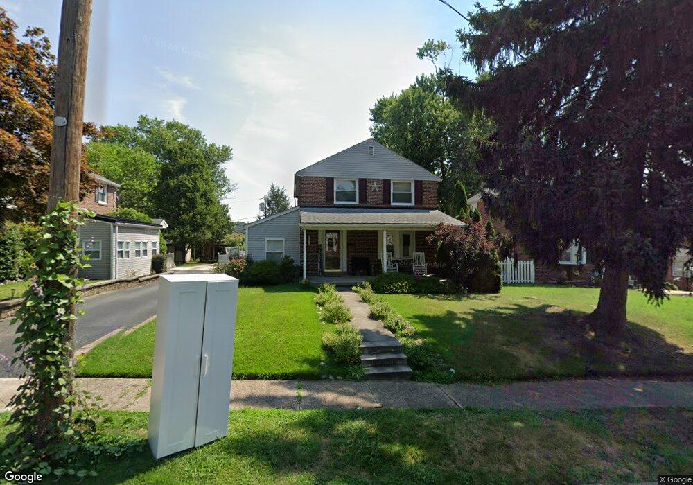
511 Glenfield Ave Glenolden, PA 19036
Estimated Value: $309,558 - $409,000
3
Beds
2
Baths
1,672
Sq Ft
$215/Sq Ft
Est. Value
About This Home
This home is located at 511 Glenfield Ave, Glenolden, PA 19036 and is currently estimated at $359,890, approximately $215 per square foot. 511 Glenfield Ave is a home located in Delaware County with nearby schools including Glenolden School, Interboro Senior High School, and Our Lady Of Fatima School.
Ownership History
Date
Name
Owned For
Owner Type
Purchase Details
Closed on
Sep 26, 1997
Sold by
Emory James Joseph and Emory Vera F
Bought by
Schmucker John J and Schmucker Regina M
Current Estimated Value
Home Financials for this Owner
Home Financials are based on the most recent Mortgage that was taken out on this home.
Original Mortgage
$114,800
Outstanding Balance
$18,379
Interest Rate
7.41%
Mortgage Type
FHA
Estimated Equity
$341,511
Create a Home Valuation Report for This Property
The Home Valuation Report is an in-depth analysis detailing your home's value as well as a comparison with similar homes in the area
Home Values in the Area
Average Home Value in this Area
Purchase History
| Date | Buyer | Sale Price | Title Company |
|---|---|---|---|
| Schmucker John J | $115,000 | -- |
Source: Public Records
Mortgage History
| Date | Status | Borrower | Loan Amount |
|---|---|---|---|
| Open | Schmucker John J | $114,800 |
Source: Public Records
Tax History Compared to Growth
Tax History
| Year | Tax Paid | Tax Assessment Tax Assessment Total Assessment is a certain percentage of the fair market value that is determined by local assessors to be the total taxable value of land and additions on the property. | Land | Improvement |
|---|---|---|---|---|
| 2025 | $5,628 | $156,950 | $45,160 | $111,790 |
| 2024 | $5,628 | $156,950 | $45,160 | $111,790 |
| 2023 | $5,506 | $156,950 | $45,160 | $111,790 |
| 2022 | $5,416 | $156,950 | $45,160 | $111,790 |
| 2021 | $7,641 | $156,950 | $45,160 | $111,790 |
| 2020 | $5,330 | $102,420 | $31,880 | $70,540 |
| 2019 | $5,271 | $102,420 | $31,880 | $70,540 |
| 2018 | $5,176 | $102,420 | $0 | $0 |
| 2017 | $5,062 | $102,420 | $0 | $0 |
| 2016 | $562 | $102,420 | $0 | $0 |
| 2015 | $574 | $102,420 | $0 | $0 |
| 2014 | $562 | $102,420 | $0 | $0 |
Source: Public Records
Map
Nearby Homes
- 464 Andrews Ave
- 618 W South Ave
- 21 Benson Dr
- 303 Urban Ave
- 311 Urban Ave
- 409 Urban Ave
- 363 Holmes Rd
- 211 Cedar Ave
- 614 Highland Terrace
- 604 Crescent Dr
- 5 Sparks Cir
- 357 Cedar Ave
- 1646 Norwood Ave
- 122 Leon Ave
- 707 Crescent Dr
- 103 Willows Ave Unit 90
- 209 Amosland Rd
- 614 S Garfield Ave
- 630 Richfield Ave
- 668 Hutchinson Terrace
- 513 Glenfield Ave
- 509 Glenfield Ave
- 515 Glenfield Ave
- 507 Glenfield Ave
- 506 W South Ave
- 508 W South Ave
- 517 Glenfield Ave
- 504 W South Ave
- 508 S Macdade Blvd
- 510 S Macdade Blvd
- 506 S Macdade Blvd
- 510 Glenfield Ave
- 508 Glenfield Ave
- 504 S Macdade Blvd
- 512 Glenfield Ave
- 512 W South Ave
- 519 Glenfield Ave
- 514 S Macdade Blvd
- 514 Glenfield Ave
- 514 W South Ave