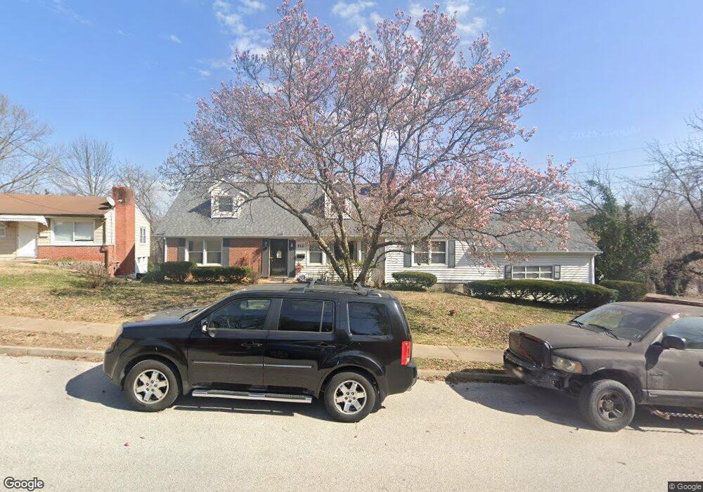
512 Holland Ave Saint Louis, MO 63119
Estimated Value: $359,000 - $464,000
4
Beds
2
Baths
2,120
Sq Ft
$189/Sq Ft
Est. Value
About This Home
This home is located at 512 Holland Ave, Saint Louis, MO 63119 and is currently estimated at $401,386, approximately $189 per square foot. 512 Holland Ave is a home located in St. Louis County with nearby schools including Avery Elementary School, Hixson Middle School, and Webster Groves High School.
Ownership History
Date
Name
Owned For
Owner Type
Purchase Details
Closed on
Oct 27, 2005
Sold by
Stewart Carolyn and White Carolyn
Bought by
Stewart Carolyn
Current Estimated Value
Home Financials for this Owner
Home Financials are based on the most recent Mortgage that was taken out on this home.
Original Mortgage
$160,000
Outstanding Balance
$85,062
Interest Rate
5.75%
Mortgage Type
Stand Alone Refi Refinance Of Original Loan
Estimated Equity
$316,324
Purchase Details
Closed on
Jan 31, 1997
Sold by
Scales Sam and Scales Cathryn M
Bought by
Stewart Kenneth and White Carolyn
Home Financials for this Owner
Home Financials are based on the most recent Mortgage that was taken out on this home.
Original Mortgage
$82,800
Interest Rate
7.68%
Mortgage Type
FHA
Create a Home Valuation Report for This Property
The Home Valuation Report is an in-depth analysis detailing your home's value as well as a comparison with similar homes in the area
Home Values in the Area
Average Home Value in this Area
Purchase History
| Date | Buyer | Sale Price | Title Company |
|---|---|---|---|
| Stewart Carolyn | -- | Nations Title Agency Mo Inc | |
| Stewart Kenneth | -- | First American Title Ins Co |
Source: Public Records
Mortgage History
| Date | Status | Borrower | Loan Amount |
|---|---|---|---|
| Open | Stewart Carolyn | $160,000 | |
| Closed | Stewart Kenneth | $82,800 |
Source: Public Records
Tax History Compared to Growth
Tax History
| Year | Tax Paid | Tax Assessment Tax Assessment Total Assessment is a certain percentage of the fair market value that is determined by local assessors to be the total taxable value of land and additions on the property. | Land | Improvement |
|---|---|---|---|---|
| 2025 | $3,304 | $53,210 | $21,190 | $32,020 |
| 2024 | $3,304 | $47,210 | $15,880 | $31,330 |
| 2023 | $3,304 | $47,210 | $15,880 | $31,330 |
| 2022 | $3,256 | $43,410 | $13,240 | $30,170 |
| 2021 | $3,245 | $43,410 | $13,240 | $30,170 |
| 2020 | $3,220 | $40,130 | $10,470 | $29,660 |
| 2019 | $3,197 | $40,130 | $10,470 | $29,660 |
| 2018 | $2,255 | $24,970 | $6,500 | $18,470 |
| 2017 | $2,240 | $24,970 | $6,500 | $18,470 |
| 2016 | $2,631 | $28,210 | $5,640 | $22,570 |
| 2015 | $2,636 | $28,210 | $5,640 | $22,570 |
| 2014 | $3,050 | $31,810 | $8,530 | $23,280 |
Source: Public Records
Map
Nearby Homes
- 112 Oakwood Ave
- 546 Holland Ave
- 617 N Elm Ave
- 814 Holland Ave
- 218 Euclid Ave
- 136 N Gore Ave
- 827 Cornell Ave
- 441 Park Rd
- 336 Madison Ave
- 901 Ennis Ave
- 330 Lithia Ave
- 610 Cornelia Ave
- 1013 Bell Ave
- 404 W Kirkham Ave
- 2918 Wingate Ct
- 529 Cyril Dr
- 619 N Bompart Ave
- 2935 Greentop Ct
- 426 W Kirkham Ave
- 515 Bismark Ave
- 516 Holland Ave
- 522 Holland Ave
- 513 Holland Ave
- 34 Fox Place
- 511 Holland Ave
- 509 Holland Ave
- 526 Holland Ave
- 3255 S Brentwood Blvd
- 2 Douglass Manor Ct
- 4 Douglass Manor Ct
- 433 Corona Ct
- 530 Holland Ave
- 15 Newport Ave
- 436 Corona Ct
- 3401 S Brentwood Blvd
- 532 Holland Ave
- 5 Douglass Manor Ct
- 1 Douglass Manor Ct
- 430 Corona Ct
- 536 Holland Ave