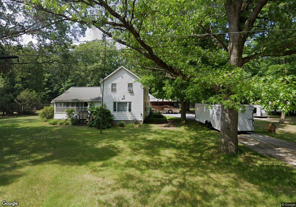
5212 Anderson Rd Montague, MI 49437
Estimated Value: $241,267 - $319,000
3
Beds
1
Bath
1,492
Sq Ft
$179/Sq Ft
Est. Value
About This Home
This home is located at 5212 Anderson Rd, Montague, MI 49437 and is currently estimated at $266,817, approximately $178 per square foot. 5212 Anderson Rd is a home located in Muskegon County with nearby schools including Montague Area Childhood Center, Oehrli Elementary School, and Nellie B. Chisholm Middle School.
Ownership History
Date
Name
Owned For
Owner Type
Purchase Details
Closed on
Aug 8, 2014
Sold by
Parker Cheryl
Bought by
Ross April L and Ross Christopher
Current Estimated Value
Home Financials for this Owner
Home Financials are based on the most recent Mortgage that was taken out on this home.
Original Mortgage
$64,865
Outstanding Balance
$49,533
Interest Rate
4.15%
Mortgage Type
FHA
Estimated Equity
$217,284
Purchase Details
Closed on
Oct 11, 2007
Sold by
Parker Cheryl A
Bought by
Parker Matthew J
Purchase Details
Closed on
Dec 27, 1999
Sold by
Schultz Joanne M
Bought by
Schultz Joanne M and Joanne M Schultz Revocable Living Trust
Create a Home Valuation Report for This Property
The Home Valuation Report is an in-depth analysis detailing your home's value as well as a comparison with similar homes in the area
Home Values in the Area
Average Home Value in this Area
Purchase History
| Date | Buyer | Sale Price | Title Company |
|---|---|---|---|
| Ross April L | $69,000 | Lighthouse Title Inc | |
| Parker Matthew J | -- | Rei | |
| Schultz Joanne M | -- | -- |
Source: Public Records
Mortgage History
| Date | Status | Borrower | Loan Amount |
|---|---|---|---|
| Open | Ross April L | $64,865 |
Source: Public Records
Tax History Compared to Growth
Tax History
| Year | Tax Paid | Tax Assessment Tax Assessment Total Assessment is a certain percentage of the fair market value that is determined by local assessors to be the total taxable value of land and additions on the property. | Land | Improvement |
|---|---|---|---|---|
| 2025 | $2,559 | $78,000 | $0 | $0 |
| 2024 | $2,218 | $81,500 | $0 | $0 |
| 2023 | $2,125 | $71,800 | $0 | $0 |
| 2022 | $2,353 | $62,800 | $0 | $0 |
| 2021 | $2,285 | $58,600 | $0 | $0 |
| 2020 | $2,271 | $54,400 | $0 | $0 |
| 2019 | $2,236 | $51,700 | $0 | $0 |
| 2018 | $2,194 | $48,400 | $0 | $0 |
| 2017 | $2,150 | $45,100 | $0 | $0 |
| 2016 | $1,841 | $41,600 | $0 | $0 |
| 2015 | -- | $42,000 | $0 | $0 |
| 2014 | -- | $42,000 | $0 | $0 |
| 2013 | -- | $41,000 | $0 | $0 |
Source: Public Records
Map
Nearby Homes
- 7544 Old Channel Trail
- 7967 Meade St
- 4894 Bowen St
- Lot 2 Old Channel Trail
- V/L Whitbeck Rd
- Lot 3 Old Channel Trail
- V/L Meade St
- 1002 S Cove Cir
- 8493 Cook St
- 5221 Jackson Ct
- 1020 S Cove Cir
- 7211 Mcfall Cir
- 940 S Lake St
- 930 S Lake St
- The Sebastian Plan at Tannery Bay
- The Jamestown Plan at Tannery Bay
- The Manistee Plan at Tannery Bay
- The Birkshire II Plan at Tannery Bay
- The Newport Plan at Tannery Bay
- The Northport Plan at Tannery Bay
- 0000 Anderson Rd
- 5200 Anderson Rd
- 5262 Anderson Rd
- 5180 Anderson Rd
- 5193 Anderson Rd
- 0 Anderson Rd
- 5138 Anderson Rd
- 5134 Anderson Rd
- 5310 Anderson Rd
- 5149 Lakeview St
- 5170 Lakeview St
- 5307 Anderson Rd
- 5114 Anderson Rd
- 5323 Anderson Rd
- 5179 Lakeview St
- 5115 Anderson Rd
- 5143 Lakeview St
- 5340 Anderson Rd
- 5337 Anderson Rd
- 5321 Lakeview St