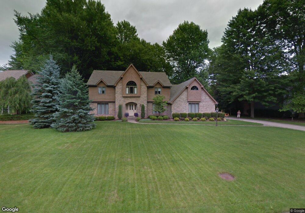
5221 Royal Palm Dr Youngstown, OH 44512
Estimated Value: $438,000 - $580,000
4
Beds
3
Baths
3,234
Sq Ft
$152/Sq Ft
Est. Value
About This Home
This home is located at 5221 Royal Palm Dr, Youngstown, OH 44512 and is currently estimated at $491,118, approximately $151 per square foot. 5221 Royal Palm Dr is a home located in Mahoning County with nearby schools including West Boulevard Elementary School, Boardman Center Middle School, and Boardman High School.
Ownership History
Date
Name
Owned For
Owner Type
Purchase Details
Closed on
Sep 25, 2020
Sold by
Pesa Christopher M
Bought by
Pesa Christopher M and Pesa Luanne
Current Estimated Value
Purchase Details
Closed on
Aug 24, 2005
Sold by
Lasalle Bank Na
Bought by
Pesa Christopher M
Home Financials for this Owner
Home Financials are based on the most recent Mortgage that was taken out on this home.
Original Mortgage
$188,400
Interest Rate
5.89%
Mortgage Type
Fannie Mae Freddie Mac
Purchase Details
Closed on
Aug 10, 2005
Sold by
Ambrosini Michelle
Bought by
Lasalle Bank Na and Structured Asset Investment Loan Trust S
Home Financials for this Owner
Home Financials are based on the most recent Mortgage that was taken out on this home.
Original Mortgage
$188,400
Interest Rate
5.89%
Mortgage Type
Fannie Mae Freddie Mac
Purchase Details
Closed on
Dec 13, 2002
Sold by
Baldwin Charles E and Baldwin Joyce
Bought by
Ambrosini Michelle
Home Financials for this Owner
Home Financials are based on the most recent Mortgage that was taken out on this home.
Original Mortgage
$360,000
Interest Rate
9.25%
Mortgage Type
Purchase Money Mortgage
Purchase Details
Closed on
Aug 24, 1998
Sold by
Corcoran Peter
Bought by
Baldwin Charles E and Baldwin Joyce
Purchase Details
Closed on
Nov 20, 1989
Bought by
Corcoran Peter and Corcoran Irene
Create a Home Valuation Report for This Property
The Home Valuation Report is an in-depth analysis detailing your home's value as well as a comparison with similar homes in the area
Home Values in the Area
Average Home Value in this Area
Purchase History
| Date | Buyer | Sale Price | Title Company |
|---|---|---|---|
| Pesa Christopher M | -- | None Available | |
| Pesa Christopher M | $235,000 | -- | |
| Lasalle Bank Na | $260,000 | -- | |
| Ambrosini Michelle | $400,000 | Reliable Title | |
| Baldwin Charles E | $260,000 | -- | |
| Corcoran Peter | $225,000 | -- |
Source: Public Records
Mortgage History
| Date | Status | Borrower | Loan Amount |
|---|---|---|---|
| Previous Owner | Pesa Christopher M | $188,400 | |
| Previous Owner | Lasalle Bank Na | $35,325 | |
| Previous Owner | Ambrosini Michelle | $360,000 |
Source: Public Records
Tax History Compared to Growth
Tax History
| Year | Tax Paid | Tax Assessment Tax Assessment Total Assessment is a certain percentage of the fair market value that is determined by local assessors to be the total taxable value of land and additions on the property. | Land | Improvement |
|---|---|---|---|---|
| 2024 | $7,127 | $140,530 | $21,520 | $119,010 |
| 2023 | $7,031 | $140,530 | $21,520 | $119,010 |
| 2022 | $7,495 | $114,760 | $21,280 | $93,480 |
| 2021 | $7,500 | $114,760 | $21,280 | $93,480 |
| 2020 | $7,712 | $114,760 | $21,280 | $93,480 |
| 2019 | $7,633 | $101,560 | $18,830 | $82,730 |
| 2018 | $6,729 | $101,560 | $18,830 | $82,730 |
| 2017 | $6,662 | $101,560 | $18,830 | $82,730 |
| 2016 | $6,422 | $96,910 | $19,890 | $77,020 |
| 2015 | $6,298 | $96,910 | $19,890 | $77,020 |
| 2014 | $6,318 | $96,910 | $19,890 | $77,020 |
| 2013 | $6,243 | $96,910 | $19,890 | $77,020 |
Source: Public Records
Map
Nearby Homes
- 990 Westport Dr
- 21.19 acres Truesdale and Lockwood Rd
- 29 Gillian Ln
- 537 W Glen Dr
- 5200 West Blvd Unit 505
- 768 Crestview Dr
- 715 Crestview Dr
- 272 Shields Rd
- 772 Ewing Rd
- 5670 Tracy Dr
- 5020 Friendship Ave
- 813 Brookfield Ave
- 4003 Shelby Rd
- 3927 Hopkins Rd
- 6632 Harrington Ave
- 396 Brookfield Ave
- 1342 Shields Rd
- 169 Wolcott Dr
- 4225 Stratford Rd
- 4042 Baymar Dr
- 5231 Royal Palm Dr
- 5211 Royal Palm Dr
- 720 Park Harbour Dr
- 5220 Royal Palm Dr
- 800 800 Park Harbour Dr
- 5210 Royal Palm Dr
- 710 Park Harbour Dr
- 741 Park Harbour Dr
- 818 Shields Rd
- 824 Shields Rd
- 731 Park Harbour Dr
- 751 Park Harbour Dr
- 830 Shields Rd
- 812 Westport Dr
- 801 Park Harbour Dr
- 806 Park Harbour Dr
- 5241 Oyster Bay Dr
- 700 Park Harbour Dr
- 721 Park Harbour Dr
- 838 Shields Rd