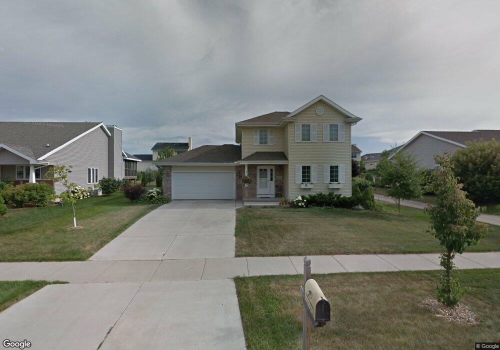
5227 Snapdragon Trail Fitchburg, WI 53711
Estimated Value: $467,285 - $522,000
3
Beds
4
Baths
1,754
Sq Ft
$280/Sq Ft
Est. Value
About This Home
This home is located at 5227 Snapdragon Trail, Fitchburg, WI 53711 and is currently estimated at $490,821, approximately $279 per square foot. 5227 Snapdragon Trail is a home located in Dane County with nearby schools including Leopold Elementary School, Cherokee Heights Middle School, and West High School.
Ownership History
Date
Name
Owned For
Owner Type
Purchase Details
Closed on
Mar 27, 2009
Sold by
Vanburen Jeremy J and Vanburen Regina B
Bought by
Shahrani Lutfi M and Shahrani Joan M
Current Estimated Value
Home Financials for this Owner
Home Financials are based on the most recent Mortgage that was taken out on this home.
Original Mortgage
$90,000
Interest Rate
5.22%
Mortgage Type
New Conventional
Purchase Details
Closed on
Jun 30, 2005
Sold by
Jones Mare A
Bought by
Vanburen Jeremy J and Vanburen Regina B
Home Financials for this Owner
Home Financials are based on the most recent Mortgage that was taken out on this home.
Original Mortgage
$47,780
Interest Rate
5.69%
Mortgage Type
Future Advance Clause Open End Mortgage
Create a Home Valuation Report for This Property
The Home Valuation Report is an in-depth analysis detailing your home's value as well as a comparison with similar homes in the area
Home Values in the Area
Average Home Value in this Area
Purchase History
| Date | Buyer | Sale Price | Title Company |
|---|---|---|---|
| Shahrani Lutfi M | $245,000 | None Available | |
| Vanburen Jeremy J | $238,900 | None Available |
Source: Public Records
Mortgage History
| Date | Status | Borrower | Loan Amount |
|---|---|---|---|
| Closed | Shahrani Lutfi M | $90,000 | |
| Previous Owner | Vanburen Jeremy J | $47,780 | |
| Previous Owner | Vanburen Jeremy J | $191,120 |
Source: Public Records
Tax History Compared to Growth
Tax History
| Year | Tax Paid | Tax Assessment Tax Assessment Total Assessment is a certain percentage of the fair market value that is determined by local assessors to be the total taxable value of land and additions on the property. | Land | Improvement |
|---|---|---|---|---|
| 2024 | $6,373 | $379,200 | $82,300 | $296,900 |
| 2023 | $6,147 | $320,500 | $82,300 | $238,200 |
| 2021 | $6,075 | $284,600 | $72,800 | $211,800 |
| 2020 | $5,907 | $284,600 | $72,800 | $211,800 |
| 2019 | $5,979 | $279,900 | $70,000 | $209,900 |
| 2018 | $5,654 | $267,600 | $70,000 | $197,600 |
| 2017 | $5,680 | $256,600 | $70,000 | $186,600 |
| 2016 | $5,668 | $247,100 | $70,000 | $177,100 |
| 2015 | $5,508 | $242,000 | $70,000 | $172,000 |
| 2014 | $5,418 | $242,800 | $70,000 | $172,800 |
| 2013 | $5,318 | $242,800 | $70,000 | $172,800 |
Source: Public Records
Map
Nearby Homes
- 57 S Gardens Way Unit 212
- 72 S Gardens Way
- 30 Keystone Way Unit 25
- 40 Keystone Way Unit 39
- 16 E Cheryl Pkwy
- 15 E Cheryl Pkwy
- 5216 Inspiration Way
- 5225 Sassafras Dr
- 5229 Sassafras Dr
- 5233 Sassafras Dr
- 5215 Sassafras Dr
- 5217 Sassafras Dr
- 5221 Sassafras Dr
- 5223 Sassafras Dr
- 5227 Sassafras Dr
- 5231 Sassafras Dr
- 5219 Sassafras Dr
- 2811 Crinkle Root Dr
- 5223 Lacy Rd
- 2813 Crinkle Root Dr
- 5223 Snapdragon Trail
- 5231 Snapdragon Trail
- 5228 Stoneman Dr
- 5219 Snapdragon Trail
- 5224 Stoneman Dr
- 5232 Stoneman Dr
- 5235 Snapdragon Trail
- 5220 Stoneman Dr
- 5228 Snapdragon Trail
- 5236 Stoneman Dr
- 5224 Snapdragon Trail
- 5215 Snapdragon Trail
- 5232 Snapdragon Trail
- 5239 Snapdragon Trail
- 5216 Stoneman Dr
- 5220 Snapdragon Trail
- 5240 Stoneman Dr
- 5236 Snapdragon Trail
- 5211 Snapdragon Trail
- 5243 Snapdragon Trail