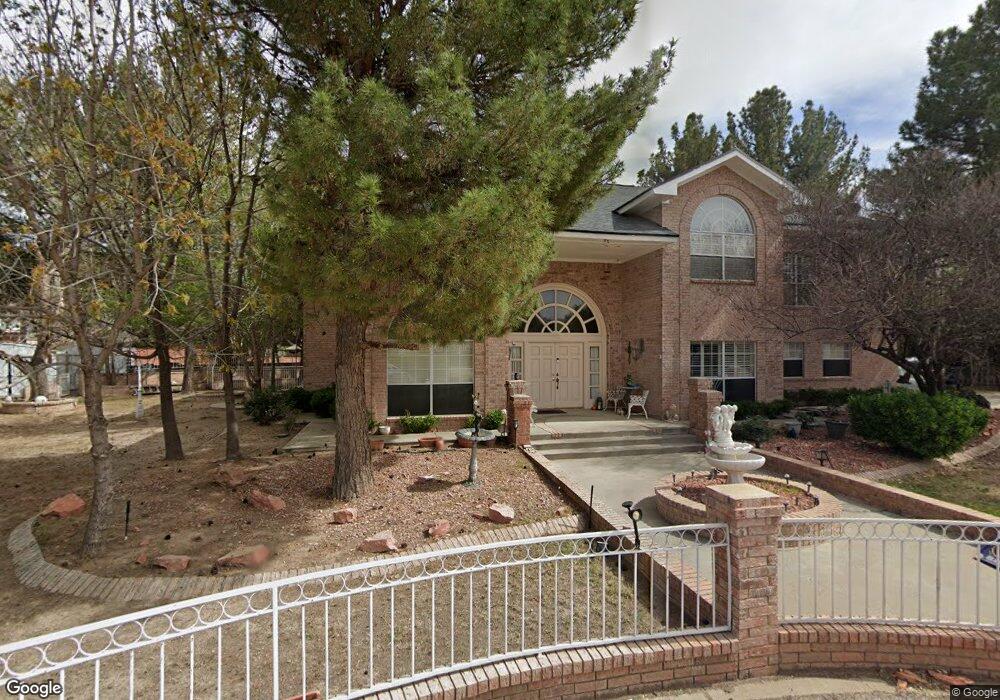
5228 White Oak Dr El Paso, TX 79932
East Bank NeighborhoodEstimated Value: $703,618 - $826,000
4
Beds
4
Baths
3,837
Sq Ft
$196/Sq Ft
Est. Value
About This Home
This home is located at 5228 White Oak Dr, El Paso, TX 79932 and is currently estimated at $751,206, approximately $195 per square foot. 5228 White Oak Dr is a home located in El Paso County with nearby schools including Don Haskins PK-8, Lincoln Middle School, and Franklin High School.
Ownership History
Date
Name
Owned For
Owner Type
Purchase Details
Closed on
Oct 22, 2001
Sold by
Jastrzebski Mateusz K
Bought by
Ahumada Miguel E and Ahumada Aida
Current Estimated Value
Purchase Details
Closed on
Jun 10, 1996
Sold by
Associates Relocation Management Co Inc
Bought by
Ahumada Michael E and Ahumada Aida G
Home Financials for this Owner
Home Financials are based on the most recent Mortgage that was taken out on this home.
Original Mortgage
$207,000
Interest Rate
7.99%
Purchase Details
Closed on
Aug 15, 1994
Sold by
Aboud Gary A and Aboud Cynthia
Bought by
Royster Theodore and Royster Dawna C
Home Financials for this Owner
Home Financials are based on the most recent Mortgage that was taken out on this home.
Original Mortgage
$194,500
Interest Rate
8.66%
Mortgage Type
Seller Take Back
Create a Home Valuation Report for This Property
The Home Valuation Report is an in-depth analysis detailing your home's value as well as a comparison with similar homes in the area
Home Values in the Area
Average Home Value in this Area
Purchase History
| Date | Buyer | Sale Price | Title Company |
|---|---|---|---|
| Ahumada Miguel E | -- | -- | |
| Ahumada Michael E | -- | -- | |
| Royster Theodore | -- | -- |
Source: Public Records
Mortgage History
| Date | Status | Borrower | Loan Amount |
|---|---|---|---|
| Previous Owner | Ahumada Michael E | $207,000 | |
| Previous Owner | Royster Theodore | $194,500 |
Source: Public Records
Tax History Compared to Growth
Tax History
| Year | Tax Paid | Tax Assessment Tax Assessment Total Assessment is a certain percentage of the fair market value that is determined by local assessors to be the total taxable value of land and additions on the property. | Land | Improvement |
|---|---|---|---|---|
| 2025 | $9,427 | $447,819 | -- | -- |
| 2024 | $9,427 | $407,108 | -- | -- |
| 2023 | $9,037 | $370,098 | $0 | $0 |
| 2022 | $9,960 | $336,453 | $0 | $0 |
| 2021 | $9,550 | $415,848 | $108,464 | $307,384 |
| 2020 | $8,546 | $278,060 | $108,464 | $169,596 |
| 2018 | $8,278 | $279,674 | $108,464 | $171,210 |
| 2017 | $7,872 | $279,461 | $108,464 | $170,997 |
| 2016 | $7,872 | $279,461 | $108,464 | $170,997 |
| 2015 | $7,404 | $279,461 | $108,464 | $170,997 |
| 2014 | $7,404 | $279,461 | $108,464 | $170,997 |
Source: Public Records
Map
Nearby Homes
- 5238 White Oak Dr
- 717 Live Oak Dr
- 735 Rio Valle Ct
- 730 Montclair Dr
- 808 Del Mar Dr
- 5051 Montoya Dr
- 114 Mulberry Ave
- 469 Country Oaks Dr
- 504 Valley Plum Ave
- 605 Bir Cir
- 650 Vera Ct
- 658 John Martin Ct
- 5525 Valley Cedar Dr
- 5440 Dougallan Ln
- 5616 Navarie Place
- 128 Serrania Dr
- 124 Serrania Dr
- 201 Mulberry Ave Unit J
- 5301 Upper Valley Rd
- 5016 Country Club Place
- 5230 White Oak Dr
- 5226 White Oak Dr
- 711 Post Oak Ct
- 709 Post Oak Ct
- 5232 White Oak Dr
- 717 Post Oak Ct
- 705 Post Oak Ct
- 5325 Montoya Dr
- 5236 White Oak Dr
- 5234 White Oak Dr
- 701 Post Oak Ct
- 5229 White Oak Dr
- 5225 White Oak Dr
- 5216 White Oak Dr
- 710 Post Oak Ct
- 5233 White Oak Dr
- 5335 Montoya Dr
- 5240 White Oak Dr
- 5221 White Oak Dr
- 5237 White Oak Dr