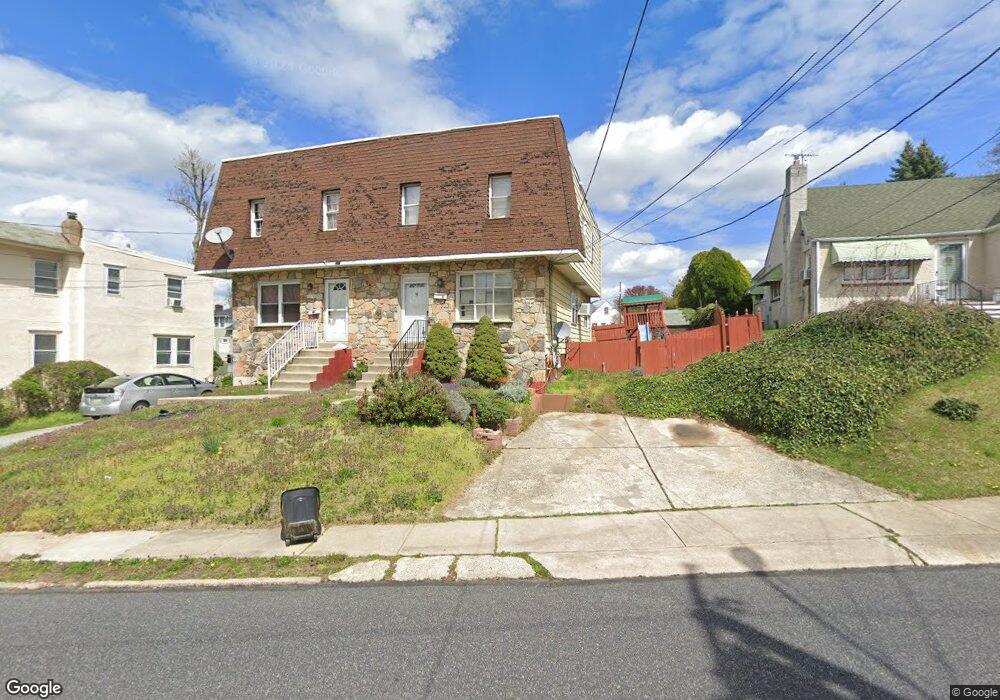
527 Ashland Ave Folcroft, PA 19032
Estimated Value: $237,526 - $286,000
3
Beds
3
Baths
1,522
Sq Ft
$174/Sq Ft
Est. Value
About This Home
This home is located at 527 Ashland Ave, Folcroft, PA 19032 and is currently estimated at $265,132, approximately $174 per square foot. 527 Ashland Ave is a home located in Delaware County with nearby schools including Delcroft School, Academy Park High School, and Liberty Baptist Academy.
Ownership History
Date
Name
Owned For
Owner Type
Purchase Details
Closed on
Sep 30, 2004
Sold by
Robinson Mark W and Robinson Rosita M
Bought by
Babatunde Folayemi O
Current Estimated Value
Home Financials for this Owner
Home Financials are based on the most recent Mortgage that was taken out on this home.
Original Mortgage
$116,910
Outstanding Balance
$58,055
Interest Rate
5.81%
Mortgage Type
Fannie Mae Freddie Mac
Estimated Equity
$207,077
Create a Home Valuation Report for This Property
The Home Valuation Report is an in-depth analysis detailing your home's value as well as a comparison with similar homes in the area
Home Values in the Area
Average Home Value in this Area
Purchase History
| Date | Buyer | Sale Price | Title Company |
|---|---|---|---|
| Babatunde Folayemi O | $129,900 | -- |
Source: Public Records
Mortgage History
| Date | Status | Borrower | Loan Amount |
|---|---|---|---|
| Open | Babatunde Folayemi O | $116,910 |
Source: Public Records
Tax History Compared to Growth
Tax History
| Year | Tax Paid | Tax Assessment Tax Assessment Total Assessment is a certain percentage of the fair market value that is determined by local assessors to be the total taxable value of land and additions on the property. | Land | Improvement |
|---|---|---|---|---|
| 2025 | $5,253 | $126,780 | $24,720 | $102,060 |
| 2024 | $5,253 | $126,780 | $24,720 | $102,060 |
| 2023 | $5,107 | $126,780 | $24,720 | $102,060 |
| 2022 | $4,831 | $126,780 | $24,720 | $102,060 |
| 2021 | $6,860 | $126,780 | $24,720 | $102,060 |
| 2020 | $4,644 | $80,860 | $18,940 | $61,920 |
| 2019 | $4,539 | $80,860 | $18,940 | $61,920 |
| 2018 | $4,429 | $80,860 | $0 | $0 |
| 2017 | $4,218 | $80,860 | $0 | $0 |
| 2016 | $444 | $80,860 | $0 | $0 |
| 2015 | $444 | $80,860 | $0 | $0 |
| 2014 | $444 | $80,860 | $0 | $0 |
Source: Public Records
Map
Nearby Homes
- 1836 Shallcross Ave
- 511 Garfield Ave
- 128 E Cooke Ave
- 41 Railroad Ave
- 1525 Elmwood Ave
- 435 Willows Ave
- 111 E Oak Ln
- 8 Stuart Ave
- 46 E Knowles Ave
- 1110 Tribbett Ave
- 726 Grant Rd
- 819 Grant Rd
- 1228 Tribbett Ave
- 4 N Chester Pike
- 837 Grant Rd
- 3 W Cooke Ave
- 211 Sharon Park Dr
- 1310 Tribbett Ave
- 125 N Scott Ave
- 2019 Delmar Dr
- 527 Ashland Ave
- 525 Ashland Ave
- 514 Dalmas Ave
- 529 Ashland Ave
- 1800 Cricket Ln
- 1725 Shallcross Ave
- 1735 Shallcross Ave
- 522 Ashland Ave
- 1802 Cricket Ln
- 520 Ashland Ave
- 1804 Cricket Ln
- 531 Ashland Ave
- 1721 Shallcross Ave
- 1806 Cricket Ln
- 1808 Cricket Ln
- 521 Dalmas Ave
- 1801 Cricket Ln
- 1810 Cricket Ln
- 510 Ashland Ave
- 515 Dalmas Ave