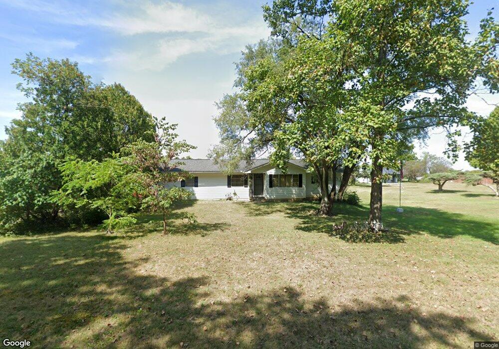
5275 Brook Rd NW Lancaster, OH 43130
Estimated Value: $241,557 - $466,000
3
Beds
1
Bath
999
Sq Ft
$314/Sq Ft
Est. Value
About This Home
This home is located at 5275 Brook Rd NW, Lancaster, OH 43130 and is currently estimated at $313,889, approximately $314 per square foot. 5275 Brook Rd NW is a home located in Fairfield County with nearby schools including Bloom Carroll Primary School, Bloom Carroll Intermediate School, and Bloom-Carroll Middle School.
Ownership History
Date
Name
Owned For
Owner Type
Purchase Details
Closed on
May 3, 2007
Sold by
Estate Of Esther Marie Chaney
Bought by
Chaney Ronald Harold and Chaney Roger Eugene
Current Estimated Value
Purchase Details
Closed on
Apr 27, 2007
Sold by
Chaney Ronald Harold and Chaney Christine
Bought by
Chaney Roger Eugene
Purchase Details
Closed on
Jul 14, 2003
Sold by
Estate Of Archie Harold Chaney
Bought by
Chaney Esther M
Create a Home Valuation Report for This Property
The Home Valuation Report is an in-depth analysis detailing your home's value as well as a comparison with similar homes in the area
Home Values in the Area
Average Home Value in this Area
Purchase History
| Date | Buyer | Sale Price | Title Company |
|---|---|---|---|
| Chaney Ronald Harold | -- | None Available | |
| Chaney Roger Eugene | -- | None Available | |
| Chaney Esther M | -- | -- |
Source: Public Records
Tax History Compared to Growth
Tax History
| Year | Tax Paid | Tax Assessment Tax Assessment Total Assessment is a certain percentage of the fair market value that is determined by local assessors to be the total taxable value of land and additions on the property. | Land | Improvement |
|---|---|---|---|---|
| 2024 | $4,248 | $52,640 | $21,000 | $31,640 |
| 2023 | $2,301 | $52,720 | $21,000 | $31,720 |
| 2022 | $2,317 | $52,720 | $21,000 | $31,720 |
| 2021 | $1,827 | $40,790 | $17,500 | $23,290 |
| 2020 | $1,849 | $40,790 | $17,500 | $23,290 |
| 2019 | $1,857 | $40,790 | $17,500 | $23,290 |
| 2018 | $1,389 | $29,010 | $14,000 | $15,010 |
| 2017 | $1,303 | $31,330 | $14,000 | $17,330 |
| 2016 | $1,264 | $31,330 | $14,000 | $17,330 |
| 2015 | $1,233 | $29,760 | $14,000 | $15,760 |
| 2014 | $1,178 | $29,760 | $14,000 | $15,760 |
| 2013 | $1,178 | $29,760 | $14,000 | $15,760 |
Source: Public Records
Map
Nearby Homes
- 0 Brook Rd NW
- 5870 Brook Rd NW
- 2831 Sterling Dr NW
- 5095 Lancaster Kirkersville Rd NW
- 4345 Lancaster Kirkersville Rd NW
- 1705 Ginder Rd NW
- 3515 Election House Rd NW
- 1502 Leonard Rd NW
- 1350 Leonard Rd NW
- 6990 Bader Rd NW
- 4656 Meadow Grove Dr NW
- 1080 Coonpath Rd NW
- 133 N Creekview Ct
- 0 Fremar Rd NE Unit Lot1 225007256
- 0 S Company St Unit Lot 2 225029545
- 0 S Company St Unit Lot 1 225029543
- 0 Coonpath Rd NW Unit Tract 4 224028093
- 0 Coonpath Rd NW Unit Tract 7 224028097
- 111 N High St
- 2865 Stringtown Rd NW
- 5253 Brook Rd NW
- 5227 Brook Rd NW
- 5210 Brook Rd NW
- 5305 Brook Rd NW
- 5300 Brook Rd NW
- 5213 Brook Rd NW
- 5315 Brook Rd NW
- 5177 Brook Rd NW
- 5320 Brook Rd NW
- 5270 Brook Rd NW
- 5150 Brook Rd NW
- 5336 Brook Rd NW
- 5145 Brook Rd NW
- 5350 Brook Rd NW
- 5113 Brook Rd NW
- 5090 Brook Rd NW
- 5400 Brook Rd NW
- 5060 Brook Rd NW
- 5049 Brook Rd NW
- 5440 Brook Rd NW