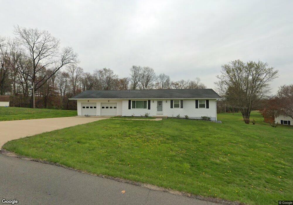
5300 Airwood Dr Zanesville, OH 43701
Estimated Value: $260,000 - $342,763
2
Beds
2
Baths
1,350
Sq Ft
$213/Sq Ft
Est. Value
About This Home
This home is located at 5300 Airwood Dr, Zanesville, OH 43701 and is currently estimated at $287,941, approximately $213 per square foot. 5300 Airwood Dr is a home located in Muskingum County with nearby schools including Perry Elementary School, East Muskingum Middle School, and Larry Miller Intermediate Elementary School.
Ownership History
Date
Name
Owned For
Owner Type
Purchase Details
Closed on
Sep 17, 2024
Sold by
5300 Airwood Dr Llc
Bought by
Rice Gregory A
Current Estimated Value
Purchase Details
Closed on
Aug 26, 2024
Sold by
Derry Allen and Derry Courtney A
Bought by
5300 Airwood Dr Llc
Purchase Details
Closed on
Jan 3, 2017
Sold by
Stutes Catharine M
Bought by
Rice Gregory A
Purchase Details
Closed on
Jun 28, 2016
Sold by
Rice Robert L
Bought by
Rice Barbara A Estate Of
Create a Home Valuation Report for This Property
The Home Valuation Report is an in-depth analysis detailing your home's value as well as a comparison with similar homes in the area
Home Values in the Area
Average Home Value in this Area
Purchase History
| Date | Buyer | Sale Price | Title Company |
|---|---|---|---|
| Rice Gregory A | -- | None Listed On Document | |
| 5300 Airwood Dr Llc | $325,000 | None Listed On Document | |
| Derry Allen | $325,000 | None Listed On Document | |
| Rice Gregory A | $50,000 | None Available | |
| Rice Barbara A Estate Of | -- | -- |
Source: Public Records
Tax History Compared to Growth
Tax History
| Year | Tax Paid | Tax Assessment Tax Assessment Total Assessment is a certain percentage of the fair market value that is determined by local assessors to be the total taxable value of land and additions on the property. | Land | Improvement |
|---|---|---|---|---|
| 2024 | $2,405 | $66,815 | $13,965 | $52,850 |
| 2023 | $1,915 | $48,685 | $9,870 | $38,815 |
| 2022 | $1,492 | $48,685 | $9,870 | $38,815 |
| 2021 | $1,476 | $48,685 | $9,870 | $38,815 |
| 2020 | $1,690 | $44,240 | $8,960 | $35,280 |
| 2019 | $1,682 | $44,240 | $8,960 | $35,280 |
| 2018 | $1,715 | $44,240 | $8,960 | $35,280 |
| 2017 | $1,286 | $34,685 | $8,960 | $25,725 |
| 2016 | $1,288 | $34,690 | $8,960 | $25,730 |
| 2015 | $1,320 | $34,690 | $8,960 | $25,730 |
| 2013 | $1,415 | $34,690 | $8,960 | $25,730 |
Source: Public Records
Map
Nearby Homes
- 400 Spring Valley Dr
- 310 Trappers Hollow Rd
- 130 Airport Rd
- 5180 Pine Valley Dr
- 6265 Canterbury Way Unit LOT 30
- 6600 Bridgeville Dr
- 1305 Bald Hill Rd
- 4460 East Pike
- 365 Walters Way
- 360 Walters Way
- 7115 East Pike
- 350 Urban Hill Rd
- 0 Sonora Rd Unit 225018643
- 0 Sonora Rd Unit 5125925
- 380 Urban Hill Rd
- 0 E Wheeling Rd Unit 5162172
- 1605 Jackson Rd
- 3620 Old Wheeling Rd
- 7915 East Pike
- 2125 Long Rd