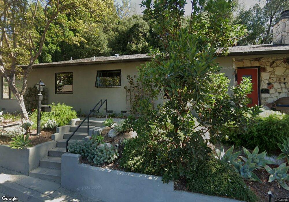
5316 Argus Dr Los Angeles, CA 90041
Eagle Rock NeighborhoodEstimated Value: $1,706,163 - $1,926,000
3
Beds
2
Baths
1,834
Sq Ft
$981/Sq Ft
Est. Value
About This Home
This home is located at 5316 Argus Dr, Los Angeles, CA 90041 and is currently estimated at $1,800,041, approximately $981 per square foot. 5316 Argus Dr is a home located in Los Angeles County with nearby schools including Eagle Rock Elementary School, Eagle Rock High School, and PUC CALS Middle School and Early College High.
Ownership History
Date
Name
Owned For
Owner Type
Purchase Details
Closed on
Nov 6, 2007
Sold by
Grant Lyle H and Grant Roseann B
Bought by
Rose Adam and Rose Sigrid
Current Estimated Value
Home Financials for this Owner
Home Financials are based on the most recent Mortgage that was taken out on this home.
Original Mortgage
$417,000
Outstanding Balance
$262,748
Interest Rate
6.3%
Mortgage Type
Purchase Money Mortgage
Estimated Equity
$1,537,293
Create a Home Valuation Report for This Property
The Home Valuation Report is an in-depth analysis detailing your home's value as well as a comparison with similar homes in the area
Home Values in the Area
Average Home Value in this Area
Purchase History
| Date | Buyer | Sale Price | Title Company |
|---|---|---|---|
| Rose Adam | $769,500 | Equity Title Company |
Source: Public Records
Mortgage History
| Date | Status | Borrower | Loan Amount |
|---|---|---|---|
| Open | Rose Adam | $417,000 |
Source: Public Records
Tax History Compared to Growth
Tax History
| Year | Tax Paid | Tax Assessment Tax Assessment Total Assessment is a certain percentage of the fair market value that is determined by local assessors to be the total taxable value of land and additions on the property. | Land | Improvement |
|---|---|---|---|---|
| 2025 | $12,144 | $1,010,738 | $722,429 | $288,309 |
| 2024 | $12,144 | $990,920 | $708,264 | $282,656 |
| 2023 | $11,908 | $971,491 | $694,377 | $277,114 |
| 2022 | $11,353 | $952,443 | $680,762 | $271,681 |
| 2021 | $11,210 | $933,768 | $667,414 | $266,354 |
| 2019 | $10,872 | $906,073 | $647,619 | $258,454 |
| 2018 | $10,790 | $888,308 | $634,921 | $253,387 |
| 2016 | $10,309 | $853,816 | $610,267 | $243,549 |
| 2015 | $10,158 | $840,992 | $601,101 | $239,891 |
| 2014 | $8,749 | $706,000 | $504,500 | $201,500 |
Source: Public Records
Map
Nearby Homes
- 1691 Hill Dr
- 1871 Hill Dr
- 5150 Argus Dr
- 2001 Hill Dr
- 5152 Vincent Ave
- 2541 Sleepy Hollow Dr
- 2580 Sleepy Hollow Dr
- 2528 Sleepy Hollow Dr
- 2110 Hill Dr
- 5146 N Maywood Ave
- 0 Corlington Rd Unit 24-460389
- 0 Maemurray Dr
- 1874 Chickasaw Ave
- 1515 Colorado Blvd
- 5062 N Maywood Ave
- 1832 Oak Tree Dr Unit 8
- 1832 Oak Tree Dr Unit 13
- 4989 Vincent Ave
- 5130 Loleta Ave
- 4984 Vincent Ave