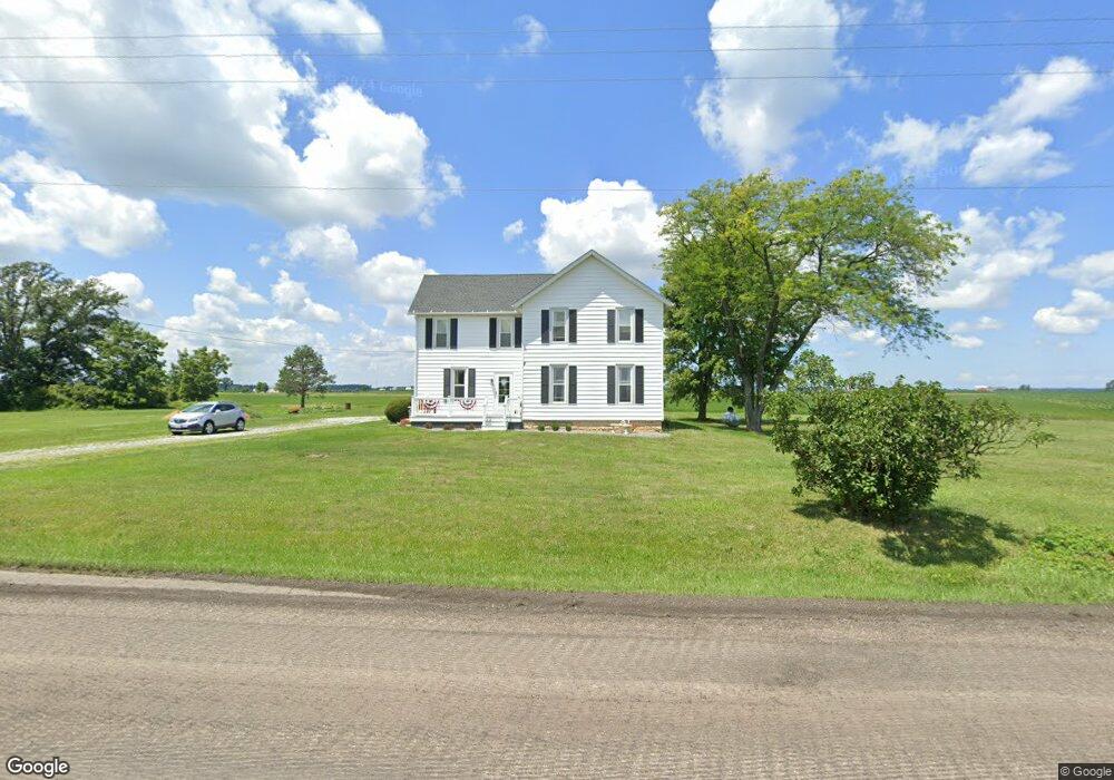
5332 State Route 547 Bellevue, OH 44811
Estimated Value: $213,181 - $323,000
2
Beds
1
Bath
2,532
Sq Ft
$104/Sq Ft
Est. Value
About This Home
This home is located at 5332 State Route 547, Bellevue, OH 44811 and is currently estimated at $263,295, approximately $103 per square foot. 5332 State Route 547 is a home located in Huron County with nearby schools including Bellevue Elementary School, Bellevue Middle School, and Bellevue High School.
Ownership History
Date
Name
Owned For
Owner Type
Purchase Details
Closed on
Nov 27, 2017
Sold by
Miller Sue Ann
Bought by
Miller Lara C and Renwand Emily Ann
Current Estimated Value
Purchase Details
Closed on
Nov 9, 2017
Sold by
Miller Sue Ann and Miller Robert M
Bought by
Miller Sue Ann
Purchase Details
Closed on
Jul 31, 2013
Bought by
Sue Robert M and Sue Ann Miller Or
Purchase Details
Closed on
Jul 23, 2013
Sold by
Miller Sue Ann and Miller Robert M
Bought by
Miller Sue Ann and Miller Robert M
Purchase Details
Closed on
Jan 26, 1990
Bought by
Sue Robert M and Sue Ann Miller
Create a Home Valuation Report for This Property
The Home Valuation Report is an in-depth analysis detailing your home's value as well as a comparison with similar homes in the area
Home Values in the Area
Average Home Value in this Area
Purchase History
| Date | Buyer | Sale Price | Title Company |
|---|---|---|---|
| Miller Lara C | -- | None Available | |
| Miller Sue Ann | -- | None Available | |
| Sue Robert M | -- | -- | |
| Miller Sue Ann | -- | Attorney | |
| Sue Robert M | -- | -- |
Source: Public Records
Tax History Compared to Growth
Tax History
| Year | Tax Paid | Tax Assessment Tax Assessment Total Assessment is a certain percentage of the fair market value that is determined by local assessors to be the total taxable value of land and additions on the property. | Land | Improvement |
|---|---|---|---|---|
| 2024 | $2,628 | $62,400 | $12,820 | $49,580 |
| 2023 | $2,628 | $51,710 | $9,560 | $42,150 |
| 2022 | $2,320 | $51,710 | $9,560 | $42,150 |
| 2021 | $2,340 | $51,710 | $9,560 | $42,150 |
| 2020 | $2,294 | $48,880 | $9,330 | $39,550 |
| 2019 | $2,280 | $48,880 | $9,330 | $39,550 |
| 2018 | $2,250 | $48,880 | $9,330 | $39,550 |
| 2017 | $1,931 | $43,920 | $9,170 | $34,750 |
| 2016 | $1,875 | $43,920 | $9,170 | $34,750 |
| 2015 | $1,927 | $43,920 | $9,170 | $34,750 |
| 2014 | $1,689 | $37,240 | $9,170 | $28,070 |
| 2013 | $1,684 | $37,240 | $9,170 | $28,070 |
Source: Public Records
Map
Nearby Homes
- 3851 Everingin Rd
- 3050 E Main St
- 140 Hobson St
- 7740 Washington St
- 817 E Main St
- 501 E Center St
- 140 Harkness St
- 111 Park Ave
- 196 Ridge St N
- 98 West St
- 206 Southwest St
- 88 W Broad St
- 129 Hamilton St
- 720 Kilbourne St
- 736 Kilbourne St
- 155 Ashford Ave
- 154 Ashford Ave
- 2 Eagle View Dr
- 9 Herrick Alley
- 17 Hollister St
- 2728 Section Line Road 30
- 2870 Section Line Road 30
- 2779 Section Line Road 30
- 5490 State Route 547
- 2695 Section Line Road 30
- 2695 Section Line Road 30
- 2596 Section Line Road 30
- 2596 Section Line 30 Rd
- 5001 State Route 547
- 3141 Section Line Road 30
- 2428 Section Line Road 30
- 2429 Section Line Road 30
- 5725 State Route 547
- 3259 Section Line Road 30
- 5313 Opperman Rd
- 2888 Dogtown Rd
- 5392 Opperman Rd