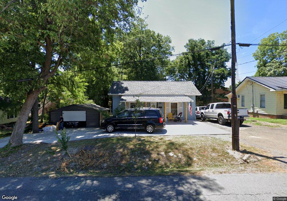
535 Hoover St Asheboro, NC 27203
Estimated Value: $72,000 - $187,000
--
Bed
1
Bath
1,140
Sq Ft
$93/Sq Ft
Est. Value
About This Home
This home is located at 535 Hoover St, Asheboro, NC 27203 and is currently estimated at $106,490, approximately $93 per square foot. 535 Hoover St is a home located in Randolph County with nearby schools including Donna L. Loflin Elementary School, South Asheboro Middle School, and Asheboro High School.
Ownership History
Date
Name
Owned For
Owner Type
Purchase Details
Closed on
Aug 29, 2023
Sold by
Southern Lewis E and Southern Sarah G
Bought by
Lewis E Southern And Sarah G Southern Revocab
Current Estimated Value
Purchase Details
Closed on
Sep 13, 2017
Sold by
Spivey Raeford Douglas and Spivey Priscilla C
Bought by
Perez Jimenez Fredy Lujano and Perez Mejia Karina
Purchase Details
Closed on
Nov 29, 2010
Sold by
Mollman Ruth B and Mollman William H
Bought by
Spivey Raeford Douglas and Spivey Priscilla C
Create a Home Valuation Report for This Property
The Home Valuation Report is an in-depth analysis detailing your home's value as well as a comparison with similar homes in the area
Home Values in the Area
Average Home Value in this Area
Purchase History
| Date | Buyer | Sale Price | Title Company |
|---|---|---|---|
| Lewis E Southern And Sarah G Southern Revocab | -- | None Listed On Document | |
| Perez Jimenez Fredy Lujano | $35,000 | None Available | |
| Spivey Raeford Douglas | $19,500 | None Available |
Source: Public Records
Tax History Compared to Growth
Tax History
| Year | Tax Paid | Tax Assessment Tax Assessment Total Assessment is a certain percentage of the fair market value that is determined by local assessors to be the total taxable value of land and additions on the property. | Land | Improvement |
|---|---|---|---|---|
| 2025 | $1,186 | $89,520 | $34,880 | $54,640 |
| 2024 | $1,186 | $89,520 | $34,880 | $54,640 |
| 2023 | $1,186 | $89,520 | $34,880 | $54,640 |
| 2022 | $1,037 | $71,900 | $34,880 | $37,020 |
| 2021 | $1,037 | $71,900 | $34,880 | $37,020 |
| 2020 | $1,037 | $71,900 | $34,880 | $37,020 |
| 2019 | $1,029 | $71,360 | $34,880 | $36,480 |
| 2018 | $979 | $66,720 | $34,880 | $31,840 |
| 2016 | $979 | $66,718 | $34,880 | $31,838 |
| 2015 | $984 | $66,718 | $34,880 | $31,838 |
| 2014 | -- | $66,718 | $34,880 | $31,838 |
Source: Public Records
Map
Nearby Homes
- 612 Sunset Ave Unit 6
- 612 Sunset Ave Unit 5
- 711 Sunset Ave Unit E
- 135 Dixon St
- 830 Sunset Ave
- 314 Pershing St
- 645 W Wainman Ave
- 923 Arnold St
- 401 Uwharrie St
- 435 Peachtree St
- 631 W Kivett St
- 617 Uwharrie St Unit N
- 627 Lee St
- 806 Windermere Ct
- 330 W Presnell St Unit 37
- 330 13 W Presnell St
- 255 Liberty St
- TBD Oakland Ave
- 828 Windermere Ct
- 243 S Elm St
- 529 Hoover St
- 539 Hoover St
- 527 Hoover St
- 612 7 Sunset Ave
- 600 Sunset Ave
- 617 Hoover St
- 618 Sunset Ave
- 612 Sunset Ave Unit 8
- 612 Sunset Ave Unit 1
- 612 Sunset Ave Unit 7
- 612 Sunset Ave Unit 12
- 612 Sunset Ave Unit 11
- 612 Sunset Ave Unit 10
- 612 Sunset Ave Unit 9
- 612 Sunset Ave Unit 2
- 612 Sunset Ave Unit 3
- 612 Sunset Ave
- 604 Hoover St
- 624 Sunset Ave
- 632 Sunset Ave