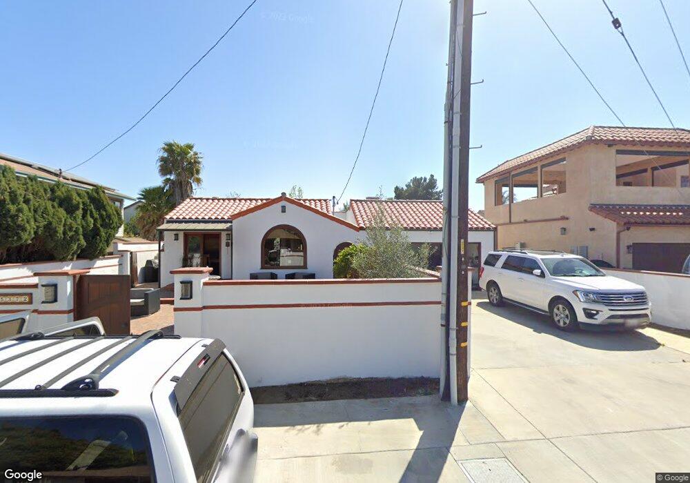
5372 Old Pirate Dr Huntington Beach, CA 92649
Estimated Value: $1,039,000 - $1,659,000
3
Beds
2
Baths
1,794
Sq Ft
$778/Sq Ft
Est. Value
About This Home
This home is located at 5372 Old Pirate Dr, Huntington Beach, CA 92649 and is currently estimated at $1,395,849, approximately $778 per square foot. 5372 Old Pirate Dr is a home located in Orange County with nearby schools including Village View Elementary School, Marine View Middle, and Marina High School.
Ownership History
Date
Name
Owned For
Owner Type
Purchase Details
Closed on
May 2, 1998
Sold by
Baer David C and Baer Anita F
Bought by
Dacquisto Peter John and Dacquisto Kendra Lee
Current Estimated Value
Home Financials for this Owner
Home Financials are based on the most recent Mortgage that was taken out on this home.
Original Mortgage
$281,200
Interest Rate
7.06%
Create a Home Valuation Report for This Property
The Home Valuation Report is an in-depth analysis detailing your home's value as well as a comparison with similar homes in the area
Home Values in the Area
Average Home Value in this Area
Purchase History
| Date | Buyer | Sale Price | Title Company |
|---|---|---|---|
| Dacquisto Peter John | $351,500 | -- |
Source: Public Records
Mortgage History
| Date | Status | Borrower | Loan Amount |
|---|---|---|---|
| Previous Owner | Dacquisto Peter John | $281,200 |
Source: Public Records
Tax History Compared to Growth
Tax History
| Year | Tax Paid | Tax Assessment Tax Assessment Total Assessment is a certain percentage of the fair market value that is determined by local assessors to be the total taxable value of land and additions on the property. | Land | Improvement |
|---|---|---|---|---|
| 2025 | $6,308 | $551,042 | $424,651 | $126,391 |
| 2024 | $6,308 | $540,238 | $416,325 | $123,913 |
| 2023 | $6,165 | $529,646 | $408,162 | $121,484 |
| 2022 | $6,074 | $519,261 | $400,159 | $119,102 |
| 2021 | $5,964 | $509,080 | $392,313 | $116,767 |
| 2020 | $5,897 | $503,861 | $388,291 | $115,570 |
| 2019 | $5,796 | $493,982 | $380,678 | $113,304 |
| 2018 | $5,667 | $484,297 | $373,214 | $111,083 |
| 2017 | $5,577 | $474,801 | $365,896 | $108,905 |
| 2016 | $5,350 | $465,492 | $358,722 | $106,770 |
| 2015 | $5,269 | $458,500 | $353,333 | $105,167 |
| 2014 | $5,166 | $449,519 | $346,412 | $103,107 |
Source: Public Records
Map
Nearby Homes
- 5200 Heil Ave Unit 18
- 5200 Heil Ave Unit 8
- 16832 Roosevelt Ln
- 5591 Heil Ave
- 17042 Twain Ln
- 17352 Eucalyptus Ln
- 5241 Glenroy Dr
- 16581 Grunion Unit 204
- 16444 Bolsa Chica St Unit 16
- 16444 Bolsa Chica St Unit 26
- 16444 Bolsa Chica St Unit 167
- 16444 Bolsa Chica St Unit 60
- 16444 Bolsa Chica St Unit 74
- 16444 Bolsa Chica St Unit 21
- 16444 Bolsa Chica St Unit 137
- 5262 Glenroy Dr
- 16551 Grunion Unit 204
- 16551 Grunion Unit 304
- 16771 Green Ln
- 17191 Corbina Ln Unit 110
- 5362 Old Pirate Dr
- 5404 Old Pirate Dr
- 5402 Old Pirate Dr
- 16781 Pembrook Ln
- 5381 Rosecrest Dr
- 5382 Doverton Dr
- 16782 Pembrook Ln
- 5401 Old Pirate Dr
- 5391 Old Pirate Dr
- 5391 Doverton Dr
- 5396 Rosecrest Dr
- 16791 Pembrook Ln
- 5415 Old Pirate Dr
- 5372 Doverton Dr
- 5371 Rosecrest Dr
- 16792 Pembrook Ln
- 16781 Wanderly Ln
- 5412 Old Pirate Dr
- 5376 Rosecrest Dr
- 5381 Doverton Dr