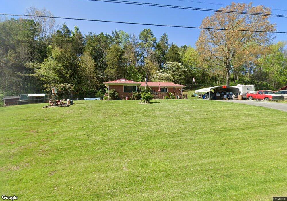
5372 Saint Paul Rd Morristown, TN 37813
Estimated Value: $197,022 - $273,000
--
Bed
1
Bath
1,208
Sq Ft
$197/Sq Ft
Est. Value
About This Home
This home is located at 5372 Saint Paul Rd, Morristown, TN 37813 and is currently estimated at $238,506, approximately $197 per square foot. 5372 Saint Paul Rd is a home located in Hamblen County with nearby schools including Witt Elementary School, Lincoln Heights Middle School, and Morristown West High School.
Ownership History
Date
Name
Owned For
Owner Type
Purchase Details
Closed on
Mar 19, 2017
Sold by
Winstead Ida Burnett L and Winstead E
Bought by
Parker Sherry S
Current Estimated Value
Purchase Details
Closed on
Mar 18, 2008
Sold by
Winstead Ida Burnett
Bought by
Hill Jason R
Purchase Details
Closed on
Oct 30, 1991
Bought by
Winstead Dale Carl and Ida Burnett
Purchase Details
Closed on
Jun 19, 1967
Purchase Details
Closed on
Dec 29, 1958
Bought by
Hale Frederick
Create a Home Valuation Report for This Property
The Home Valuation Report is an in-depth analysis detailing your home's value as well as a comparison with similar homes in the area
Home Values in the Area
Average Home Value in this Area
Purchase History
| Date | Buyer | Sale Price | Title Company |
|---|---|---|---|
| Parker Sherry S | -- | -- | |
| Parker Sherry S | -- | -- | |
| Hill Jason R | -- | -- | |
| Winstead Dale Carl | $20,000 | -- | |
| -- | -- | -- | |
| Hale Frederick | -- | -- |
Source: Public Records
Tax History Compared to Growth
Tax History
| Year | Tax Paid | Tax Assessment Tax Assessment Total Assessment is a certain percentage of the fair market value that is determined by local assessors to be the total taxable value of land and additions on the property. | Land | Improvement |
|---|---|---|---|---|
| 2024 | $483 | $24,500 | $4,500 | $20,000 |
| 2023 | $483 | $24,500 | $0 | $0 |
| 2022 | $483 | $24,500 | $4,500 | $20,000 |
| 2021 | $420 | $24,750 | $4,500 | $20,250 |
| 2020 | $420 | $24,750 | $4,500 | $20,250 |
| 2019 | $420 | $22,825 | $4,500 | $18,325 |
| 2018 | $420 | $22,825 | $4,500 | $18,325 |
| 2017 | $420 | $22,825 | $4,500 | $18,325 |
| 2016 | $420 | $22,825 | $4,500 | $18,325 |
| 2015 | $422 | $22,825 | $4,500 | $18,325 |
| 2014 | -- | $22,825 | $4,500 | $18,325 |
| 2013 | -- | $24,800 | $0 | $0 |
Source: Public Records
Map
Nearby Homes
- Lot PT11 Drew Dr
- 5056 Spencer Hale Rd
- 5474 Saint Paul Rd
- 5704 Long Creek Rd
- 1163 Nathan Dr
- 4996 Saint Paul Rd
- 0 Old White Pine Rd
- 5262 Buell Chapel Rd
- TBD Buell Chapel Rd
- 5972 Leepers Ferry Rd
- 848 Spencer Hale Rd
- 4207 Clyde Thomas Rd
- 3582 Baker Springs Rd
- 0 Tbd River View Dr Unit Lot@WP001
- 1516 River Path
- 1509 River Path
- 1515 River Path
- 1515 River Path Unit 46
- 1540 River Path
- 1558 River Path
- 5350 Saint Paul Rd
- 5359 Saint Paul Rd
- 5326 Saint Paul Rd
- 5337 Saint Paul Rd
- 5322 Saint Paul Rd
- 915 Drew Dr
- 921 Drew Dr
- 905 Drew Dr
- 5327 Saint Paul Rd
- 5284 Saint Paul Rd
- 5315 Saint Paul Rd
- 968 Drew Dr
- 968 Drew Dr
- 933 Drew Dr
- 5432 Saint Paul Rd
- 5280 Saint Paul Rd
- 5172 Spencer Hale Rd
- 941 Drew Dr
- LOT 1 Spencer Hale Rd Unit S/D Bridlewood
- 5216 Spencer Hale Rd