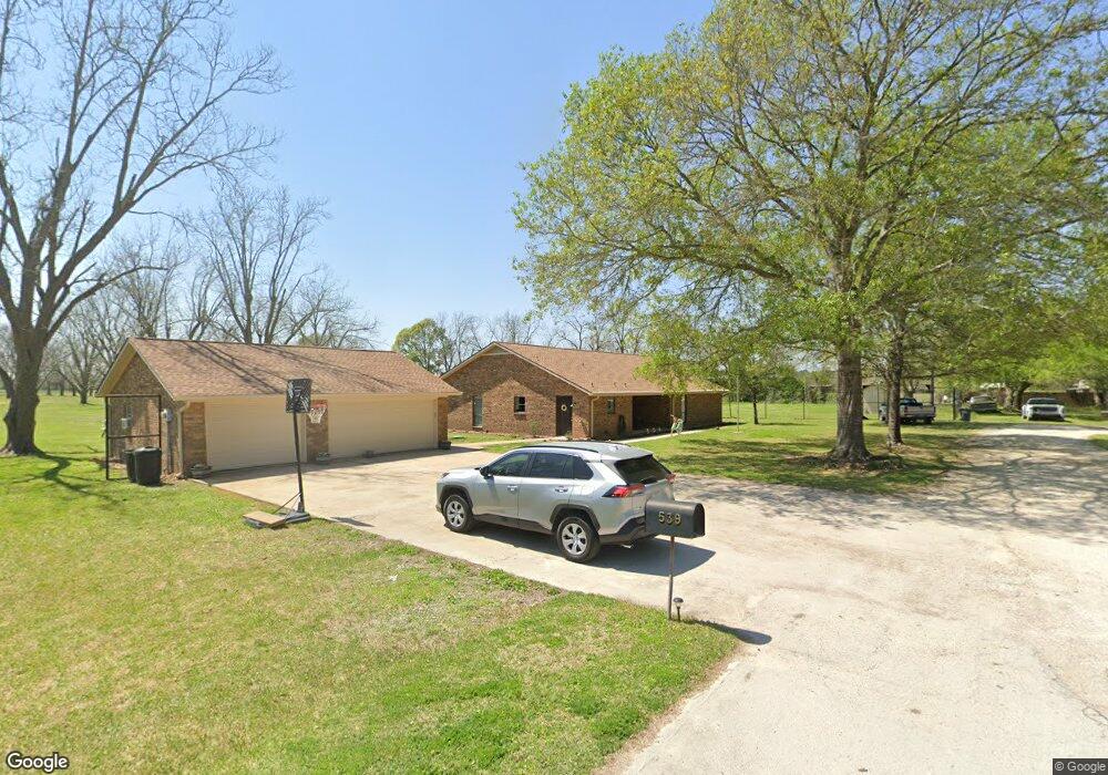
539 N Gum Gully Rd Crosby, TX 77532
Estimated Value: $418,097 - $585,000
3
Beds
2
Baths
2,301
Sq Ft
$206/Sq Ft
Est. Value
About This Home
This home is located at 539 N Gum Gully Rd, Crosby, TX 77532 and is currently estimated at $474,774, approximately $206 per square foot. 539 N Gum Gully Rd is a home located in Harris County with nearby schools including Newport Elementary School, Crosby Middle School, and Crosby High School.
Ownership History
Date
Name
Owned For
Owner Type
Purchase Details
Closed on
Jun 9, 2020
Sold by
Blankenship Suzanne W and Blankenship Suzanne
Bought by
Blackburn William Michael and Blackburn Geri Ann
Current Estimated Value
Home Financials for this Owner
Home Financials are based on the most recent Mortgage that was taken out on this home.
Original Mortgage
$204,250
Outstanding Balance
$141,943
Interest Rate
2.7%
Mortgage Type
New Conventional
Estimated Equity
$332,831
Purchase Details
Closed on
May 8, 1997
Sold by
Harris County Fresh Water Supply Dist
Bought by
Blankenship Gerald and Blankenship Suzanne
Create a Home Valuation Report for This Property
The Home Valuation Report is an in-depth analysis detailing your home's value as well as a comparison with similar homes in the area
Home Values in the Area
Average Home Value in this Area
Purchase History
| Date | Buyer | Sale Price | Title Company |
|---|---|---|---|
| Blackburn William Michael | -- | None Available | |
| Blankenship Gerald | -- | -- |
Source: Public Records
Mortgage History
| Date | Status | Borrower | Loan Amount |
|---|---|---|---|
| Open | Blackburn William Michael | $204,250 |
Source: Public Records
Tax History Compared to Growth
Tax History
| Year | Tax Paid | Tax Assessment Tax Assessment Total Assessment is a certain percentage of the fair market value that is determined by local assessors to be the total taxable value of land and additions on the property. | Land | Improvement |
|---|---|---|---|---|
| 2025 | $2,875 | $418,391 | $198,108 | $220,283 |
| 2024 | $2,875 | $418,391 | $198,108 | $220,283 |
| 2023 | $2,875 | $406,267 | $198,108 | $208,159 |
| 2022 | $3,849 | $404,393 | $198,108 | $206,285 |
| 2021 | $3,621 | $172,895 | $88,048 | $84,847 |
| 2020 | $3,213 | $172,895 | $15,029 | $157,866 |
| 2019 | $3,077 | $172,895 | $15,029 | $157,866 |
| 2018 | $874 | $118,875 | $7,514 | $111,361 |
| 2017 | $5,647 | $118,875 | $7,514 | $111,361 |
| 2016 | $2,824 | $118,875 | $7,514 | $111,361 |
| 2015 | $1,099 | $118,875 | $7,514 | $111,361 |
| 2014 | $1,099 | $118,868 | $7,514 | $111,354 |
Source: Public Records
Map
Nearby Homes
- 435 Indian Shores Rd
- 202 W Stroker Rd
- 20007 Wig Wam Ln
- 1001 Indian Shores Rd
- 704 E Stroker Rd - Tract 2
- 1404 Indian Shores Rd
- 0 Indian Shores Rd Unit 14368981
- 1406 Indian Shores Rd
- 215 Reidland Rd
- 0 E Stroker Rd
- 207 Florabunda Ln
- 0 Morgan Rd
- 1506 Silver Moon Trail
- 414 Antelope Dr
- 20011 Flying Dove Trail
- 223 Lilac Cir
- 415 Moose Dr
- 20183 Green Mallard St
- 20179 Green Mallard St
- 20182 Green Mallard St
- 538 N Gum Gully Rd
- 541 N Gum Gully Rd
- 540 N Gum Gully Rd
- 605 W Stroker Rd
- 615 W Stroker Rd
- 543 N Gum Gully Rd
- 550 N Gum Gully Rd
- 527 N Gum Gully Rd
- 525 N Gum Gully Rd
- 540 W Stroker Rd
- 542 N Gum Gully Rd
- 523 N Gum Gully Rd
- 606 W Stroker Rd
- 536 Gum Gully Rd
- 536 N Gum Gully Rd
- 519 Gum Gully Rd
- 701 W Stroker Rd
- 524 N Gum Gully Rd
- 373 W Stroker Rd
- 650 W Stroker Rd