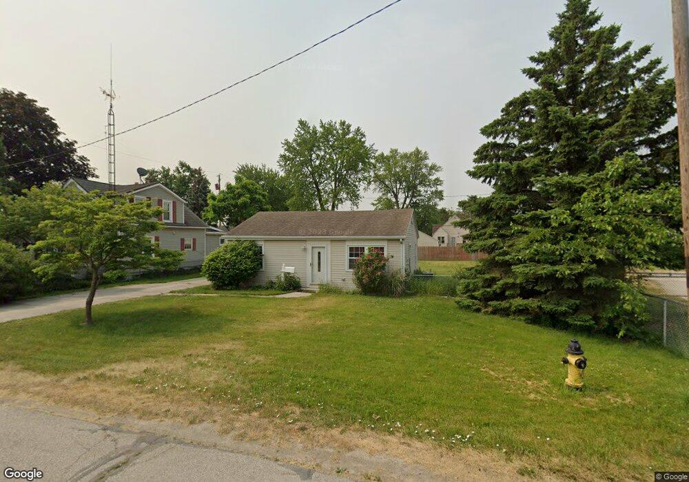
5405 Hammond Dr Toledo, OH 43611
Shoreland NeighborhoodEstimated Value: $135,000 - $147,398
2
Beds
1
Bath
1,009
Sq Ft
$142/Sq Ft
Est. Value
About This Home
This home is located at 5405 Hammond Dr, Toledo, OH 43611 and is currently estimated at $143,100, approximately $141 per square foot. 5405 Hammond Dr is a home located in Lucas County with nearby schools including Shoreland Elementary School, Washington Junior High School, and Jefferson Junior High School.
Ownership History
Date
Name
Owned For
Owner Type
Purchase Details
Closed on
Apr 20, 2022
Sold by
Tutak Gary J & Patricia R (Trustees)
Bought by
Tutak Patricia R (Suc Tr) Of The Gary J & Patricia
Current Estimated Value
Purchase Details
Closed on
Feb 15, 2012
Sold by
Tutak Gary L and Tutak Patricia R
Bought by
Tutak Gary J and Tutak Patricia R
Purchase Details
Closed on
Nov 8, 2006
Sold by
Murphy Gerald M
Bought by
Tutak Gary L and Tutak Patricia R
Purchase Details
Closed on
Jan 15, 1991
Sold by
Murphy Charles
Create a Home Valuation Report for This Property
The Home Valuation Report is an in-depth analysis detailing your home's value as well as a comparison with similar homes in the area
Home Values in the Area
Average Home Value in this Area
Purchase History
| Date | Buyer | Sale Price | Title Company |
|---|---|---|---|
| Tutak Patricia R (Suc Tr) Of The Gary J & Patricia | -- | -- | |
| Tutak Gary J | -- | None Available | |
| Tutak Gary L | $52,500 | American 1St | |
| -- | -- | -- |
Source: Public Records
Tax History Compared to Growth
Tax History
| Year | Tax Paid | Tax Assessment Tax Assessment Total Assessment is a certain percentage of the fair market value that is determined by local assessors to be the total taxable value of land and additions on the property. | Land | Improvement |
|---|---|---|---|---|
| 2024 | $1,510 | $41,825 | $14,490 | $27,335 |
| 2023 | $2,588 | $29,855 | $12,355 | $17,500 |
| 2022 | $2,578 | $29,855 | $12,355 | $17,500 |
| 2021 | $2,583 | $29,855 | $12,355 | $17,500 |
| 2020 | $2,464 | $24,465 | $10,115 | $14,350 |
| 2019 | $2,414 | $24,465 | $10,115 | $14,350 |
| 2018 | $2,139 | $24,465 | $10,115 | $14,350 |
| 2017 | $2,073 | $21,035 | $11,410 | $9,625 |
| 2016 | $2,048 | $60,100 | $32,600 | $27,500 |
| 2015 | $2,040 | $60,100 | $32,600 | $27,500 |
| 2014 | $1,728 | $21,040 | $11,410 | $9,630 |
| 2013 | $1,728 | $21,040 | $11,410 | $9,630 |
Source: Public Records
Map
Nearby Homes
- 5346 Patriot Dr
- 5310 Hammond Dr
- 5516 Fortune Dr
- 5433 Brophy Dr
- 2545 Woodfox Dr
- 2211 E Harbor Dr
- 2324 Havencrest Ct
- 5331 Whitehouse Dr
- 5531 Ottawa River Rd
- 2207 E Harbor Dr
- 2733 130th St
- 5534 Suder Ave
- 5504 Ketukkee Trail
- 2240 Ruthanne Dr
- 2642 124th St
- 6205 Windamar Rd
- 2650 120th St
- 2827 126th St
- 5454 Brook Point Rd
- 5457 Thornbrook Trail
- 5401 Hammond Dr
- 5410 Patriot Dr
- 5406 Patriot Dr
- 5418 Patriot Dr
- 5402 Patriot Dr
- 5420 Patriot Dr
- 5410 Hammond Dr
- 5339 Hammond Dr
- 5422 Patriot Dr
- 5342 Patriot Dr
- 5434 Patriot Dr
- 5344 Hammond Dr
- 5335 Hammond Dr
- 5331 Hammond Dr
- 5405 Patriot Dr
- 5409 Belpre Dr
- 5409 Patriot Dr
- 5405 Belpre Dr
- 5336 Patriot Dr
- 5401 Belpre Dr