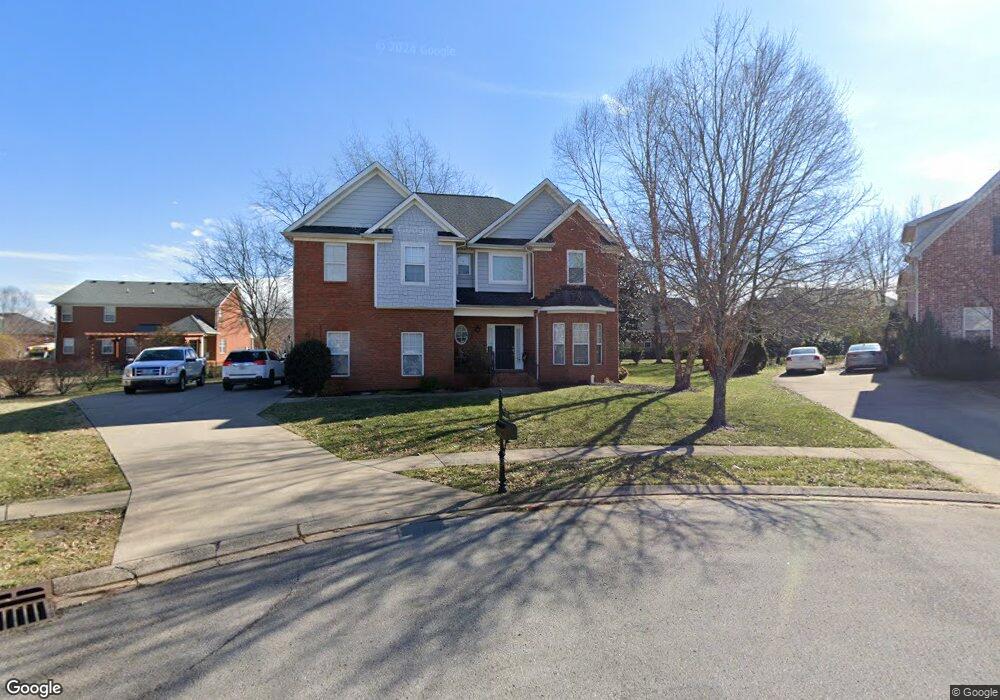
5432 Ennismore Ct Murfreesboro, TN 37128
Estimated Value: $523,000 - $615,000
4
Beds
3
Baths
2,860
Sq Ft
$196/Sq Ft
Est. Value
About This Home
This home is located at 5432 Ennismore Ct, Murfreesboro, TN 37128 and is currently estimated at $559,635, approximately $195 per square foot. 5432 Ennismore Ct is a home located in Rutherford County with nearby schools including Blackman Elementary School, Overall Creek Elementary School, and Blackman Middle School.
Ownership History
Date
Name
Owned For
Owner Type
Purchase Details
Closed on
May 29, 2015
Sold by
Jackson Douglas C
Bought by
Roseman Timothy
Current Estimated Value
Home Financials for this Owner
Home Financials are based on the most recent Mortgage that was taken out on this home.
Original Mortgage
$180,000
Outstanding Balance
$139,614
Interest Rate
3.79%
Mortgage Type
New Conventional
Estimated Equity
$420,021
Create a Home Valuation Report for This Property
The Home Valuation Report is an in-depth analysis detailing your home's value as well as a comparison with similar homes in the area
Home Values in the Area
Average Home Value in this Area
Purchase History
| Date | Buyer | Sale Price | Title Company |
|---|---|---|---|
| Roseman Timothy | $225,000 | -- |
Source: Public Records
Mortgage History
| Date | Status | Borrower | Loan Amount |
|---|---|---|---|
| Open | Roseman Timothy | $180,000 |
Source: Public Records
Tax History Compared to Growth
Tax History
| Year | Tax Paid | Tax Assessment Tax Assessment Total Assessment is a certain percentage of the fair market value that is determined by local assessors to be the total taxable value of land and additions on the property. | Land | Improvement |
|---|---|---|---|---|
| 2025 | $2,929 | $103,550 | $15,000 | $88,550 |
| 2024 | $2,929 | $103,550 | $15,000 | $88,550 |
| 2023 | $1,943 | $103,550 | $15,000 | $88,550 |
| 2022 | $1,674 | $103,550 | $15,000 | $88,550 |
| 2021 | $1,658 | $74,725 | $15,000 | $59,725 |
| 2020 | $1,658 | $74,725 | $15,000 | $59,725 |
| 2019 | $1,658 | $74,725 | $15,000 | $59,725 |
| 2018 | $2,278 | $74,725 | $0 | $0 |
| 2017 | $2,422 | $62,325 | $0 | $0 |
| 2016 | $2,422 | $62,325 | $0 | $0 |
| 2015 | $2,422 | $62,325 | $0 | $0 |
| 2014 | -- | $62,325 | $0 | $0 |
| 2013 | -- | $62,250 | $0 | $0 |
Source: Public Records
Map
Nearby Homes
- 2108 Olmstead Ct
- 5408 Middlebury Dr
- 5227 Starnes Dr
- 1232 Stockwell Dr
- 4814 Saint Ives Dr
- 1235 Timber Creek Dr
- 1526 Dewsbury Dr
- 1320 Hartlepool Dr
- 5108 Saint Ives Dr
- 5350 Tony Lama Ln
- 5309 Perlou Ln
- 827 Stovers Glen Dr
- 629 Brinkley Rd
- 4826 Trevino Ct
- 4332 Pender Ct
- 814 Stovers Glen
- 548 Brinkley Rd
- 1716 John Lee Ln
- 802 Licinius Ln
- 1021 Julian Way
- 5436 Ennismore Ct
- 1327 Dunraven Dr
- 5433 Ennismore Ct
- 1323 Dunraven Dr
- 1331 Dunraven Dr
- 5437 Ennismore Ct
- 1402 Balson Dr
- 1319 Dunraven Dr
- 1335 Dunraven Dr
- 1338 Balson Dr
- 5434 Saint Ives Dr
- 1334 Balson Dr
- 5438 Saint Ives Dr
- 1410 Balson Dr
- 1326 Dunraven Dr
- 5430 Saint Ives Dr
- 1339 Dunraven Dr
- 1322 Dunraven Dr
- 5442 Saint Ives Dr
- 1330 Balson Dr