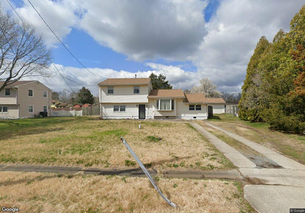
5456 Snyder Ave Millville, NJ 08332
Estimated Value: $221,025 - $268,000
--
Bed
--
Bath
1,628
Sq Ft
$149/Sq Ft
Est. Value
About This Home
This home is located at 5456 Snyder Ave, Millville, NJ 08332 and is currently estimated at $243,256, approximately $149 per square foot. 5456 Snyder Ave is a home located in Cumberland County with nearby schools including Dr. William Mennies School, Landis Middle School, and Vineland Senior High School.
Ownership History
Date
Name
Owned For
Owner Type
Purchase Details
Closed on
Jun 1, 2024
Sold by
Howard Kevin
Bought by
Premium Rentals Llc
Current Estimated Value
Purchase Details
Closed on
Oct 29, 2002
Sold by
Daly Dennis
Bought by
Howard Kevin
Purchase Details
Closed on
Jul 19, 2002
Sold by
Jones Darlene
Bought by
Howard Kevin
Home Financials for this Owner
Home Financials are based on the most recent Mortgage that was taken out on this home.
Original Mortgage
$66,320
Interest Rate
6.64%
Purchase Details
Closed on
Oct 26, 2001
Sold by
Dodds Robert H
Bought by
Howard Kevin
Purchase Details
Closed on
Feb 26, 1985
Bought by
Howard Kevin
Create a Home Valuation Report for This Property
The Home Valuation Report is an in-depth analysis detailing your home's value as well as a comparison with similar homes in the area
Home Values in the Area
Average Home Value in this Area
Purchase History
| Date | Buyer | Sale Price | Title Company |
|---|---|---|---|
| Premium Rentals Llc | -- | None Listed On Document | |
| Howard Kevin | $42,840 | -- | |
| Howard Kevin | $82,900 | -- | |
| Howard Kevin | $28,000 | -- | |
| Howard Kevin | $39,900 | -- |
Source: Public Records
Mortgage History
| Date | Status | Borrower | Loan Amount |
|---|---|---|---|
| Previous Owner | Howard Kevin | $66,320 |
Source: Public Records
Tax History Compared to Growth
Tax History
| Year | Tax Paid | Tax Assessment Tax Assessment Total Assessment is a certain percentage of the fair market value that is determined by local assessors to be the total taxable value of land and additions on the property. | Land | Improvement |
|---|---|---|---|---|
| 2025 | $3,754 | $117,900 | $22,900 | $95,000 |
| 2024 | $3,754 | $117,900 | $22,900 | $95,000 |
| 2023 | $3,729 | $117,900 | $22,900 | $95,000 |
| 2022 | $3,618 | $117,900 | $22,900 | $95,000 |
| 2021 | $3,552 | $117,900 | $22,900 | $95,000 |
| 2020 | $3,451 | $117,900 | $22,900 | $95,000 |
| 2019 | $3,404 | $117,900 | $22,900 | $95,000 |
| 2018 | $3,314 | $117,900 | $22,900 | $95,000 |
| 2017 | $3,148 | $117,900 | $22,900 | $95,000 |
| 2016 | $3,037 | $117,900 | $22,900 | $95,000 |
| 2015 | $2,925 | $117,900 | $22,900 | $95,000 |
| 2014 | $2,766 | $117,900 | $22,900 | $95,000 |
Source: Public Records
Map
Nearby Homes
- 1921 Mountain Dr
- 2801 Leaming Mill Rd
- 9 Greenlawn Ct
- 4225 Mays Landing Rd
- 447 Manor Ave
- 429 Manor Ave
- 2110 Mays Landing Rd Unit 199
- 2110 Mays Landing Rd Unit 14
- 2110 Mays Landing Rd Unit 73
- 2110 Mays Landing Rd Unit 77
- 2110 Mays Landing Rd Unit 169
- 2110 Mays Landing Rd
- 2110 Mays Landing Rd Unit 317
- 2110 Mays Landing Rd Unit 267
- 2110 Mays Landing Rd Unit 308
- 4770 Stoney Bridge Rd
- 1812 Newcombtown Rd
- 1916 Bessie Way
- 2655 Mays Landing Rd
- 2402 Shelburn Rd
- 5474 Snyder Ave
- 5461 High Ridge Rd
- 5481 High Ridge Rd
- 5492 Snyder Ave
- 5501 High Ridge Rd
- 5510 Snyder Ave
- 5461 Snyder Ave
- 5519 High Ridge Rd
- 1920 Mountain Dr
- 1900 Mountain Dr
- 5542 Snyder Ave
- 5499 Snyder Ave
- 1903 Mountain Dr
- 5551 High Ridge Rd
- 5530 High Ridge Rd
- 5530 High Ridge
- 5431 Snyder Ave
- 1880 Mountain Dr
- 5346 Snyder Ave
- 5564 Snyder Ave