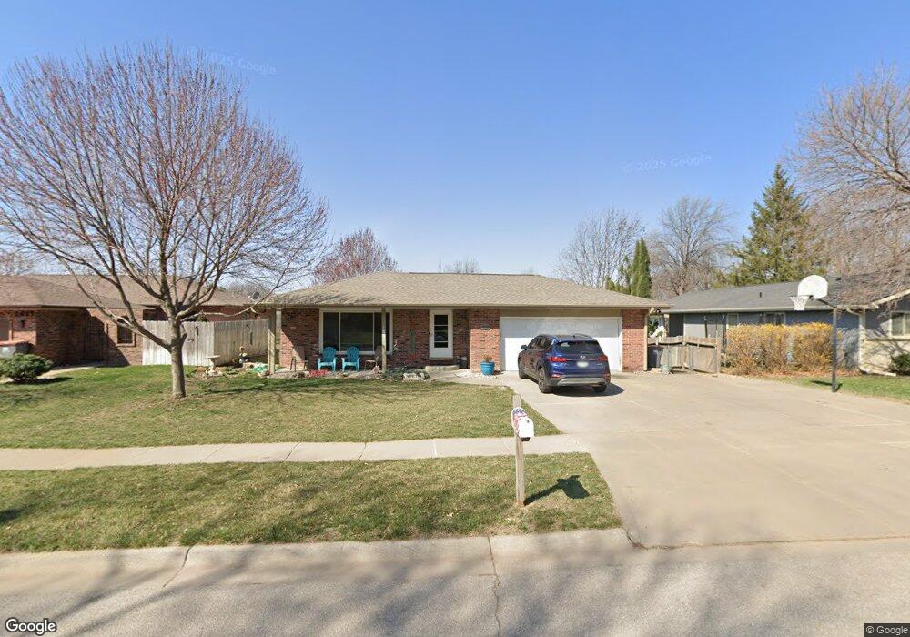
5509 S 20th St Lincoln, NE 68512
Southwood NeighborhoodEstimated Value: $297,000 - $362,000
4
Beds
3
Baths
2,772
Sq Ft
$119/Sq Ft
Est. Value
About This Home
This home is located at 5509 S 20th St, Lincoln, NE 68512 and is currently estimated at $328,558, approximately $118 per square foot. 5509 S 20th St is a home located in Lancaster County with nearby schools including Hill Elementary School, Scott Middle School, and Southwest High School.
Ownership History
Date
Name
Owned For
Owner Type
Purchase Details
Closed on
Aug 13, 1999
Sold by
Jenkins Donald E
Bought by
Speth Todd A and Speth Linda Kay
Current Estimated Value
Home Financials for this Owner
Home Financials are based on the most recent Mortgage that was taken out on this home.
Original Mortgage
$90,000
Interest Rate
7.71%
Create a Home Valuation Report for This Property
The Home Valuation Report is an in-depth analysis detailing your home's value as well as a comparison with similar homes in the area
Home Values in the Area
Average Home Value in this Area
Purchase History
| Date | Buyer | Sale Price | Title Company |
|---|---|---|---|
| Speth Todd A | $144,000 | -- |
Source: Public Records
Mortgage History
| Date | Status | Borrower | Loan Amount |
|---|---|---|---|
| Closed | Speth Todd A | $90,000 |
Source: Public Records
Tax History Compared to Growth
Tax History
| Year | Tax Paid | Tax Assessment Tax Assessment Total Assessment is a certain percentage of the fair market value that is determined by local assessors to be the total taxable value of land and additions on the property. | Land | Improvement |
|---|---|---|---|---|
| 2025 | $3,962 | $367,200 | $69,000 | $298,200 |
| 2024 | $3,962 | $286,700 | $69,000 | $217,700 |
| 2023 | $4,805 | $286,700 | $69,000 | $217,700 |
| 2022 | $4,765 | $239,100 | $54,000 | $185,100 |
| 2021 | $4,508 | $239,100 | $54,000 | $185,100 |
| 2020 | $4,018 | $210,300 | $54,000 | $156,300 |
| 2019 | $4,019 | $210,300 | $54,000 | $156,300 |
| 2018 | $4,077 | $212,400 | $54,000 | $158,400 |
| 2017 | $4,115 | $212,400 | $54,000 | $158,400 |
| 2016 | $3,959 | $203,300 | $48,000 | $155,300 |
| 2015 | $3,932 | $203,300 | $48,000 | $155,300 |
| 2014 | $3,337 | $171,600 | $48,000 | $123,600 |
| 2013 | -- | $171,600 | $48,000 | $123,600 |
Source: Public Records
Map
Nearby Homes
- 5430 S 20th Street Cir
- 5435 Tipperary Trail
- 1820 Normandy Ln
- 2120 S Canterbury Ln
- 1734 Normandy Ln
- 1730 Trelawney Dr
- 2200 Autumn Ct
- 2210 Autumn Ct
- 2220 Autumn Ct
- 2230 Autumn Ct
- 2240 Autumn Ct
- 2300 Springtime Ct
- 2201 Autumn Ct
- 2215 Autumn Ct
- 2235 Autumn Ct
- 2310 Springtime Ct
- 5200 Cameron Ct
- 2320 Springtime Ct
- 2307 Springtime Ct
- 2330 Springtime Ct
- 5517 S 20th St
- 1935 King Arthur Ct
- 5519 S 20th St
- 1929 King Arthur Ct
- 5525 S 20th St
- 5516 S 20th St
- 5508 S 20th St
- 5527 S 20th St
- 1923 King Arthur Ct
- 5524 S 20th St
- 5500 S 20th St
- 5447 S 20th Street Cir
- 5533 S 20th St
- 5454 S 20th Street Cir
- 2000 Heather Ln
- 5535 S 20th St
- 1920 King Arthur Ct
- 5439 S 20th Street Cir
- 1919 King Arthur Ct
- 5521 Tipperary Trail