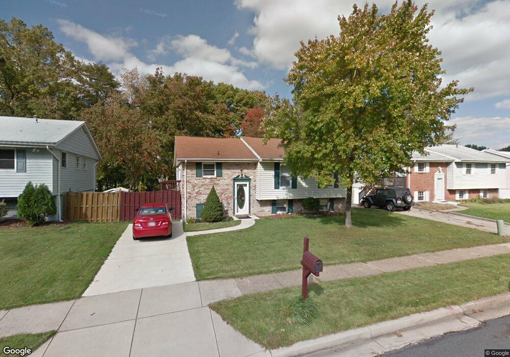
556 Lanny Ct Millersville, MD 21108
Estimated Value: $402,000 - $487,000
--
Bed
2
Baths
1,088
Sq Ft
$398/Sq Ft
Est. Value
About This Home
This home is located at 556 Lanny Ct, Millersville, MD 21108 and is currently estimated at $433,004, approximately $397 per square foot. 556 Lanny Ct is a home located in Anne Arundel County with nearby schools including Rippling Woods Elementary School, Old Mill Middle School North, and Old Mill High School.
Ownership History
Date
Name
Owned For
Owner Type
Purchase Details
Closed on
Nov 13, 2002
Sold by
Ryan Charles A
Bought by
Carelock Freddie and Carelock Maria A
Current Estimated Value
Purchase Details
Closed on
Nov 3, 1999
Sold by
Forman Debra A
Bought by
Ryan Charles A and Ryan Margaret K
Purchase Details
Closed on
Aug 13, 1992
Sold by
Brazeal Thomas A
Bought by
Forman Debra A
Home Financials for this Owner
Home Financials are based on the most recent Mortgage that was taken out on this home.
Original Mortgage
$102,400
Interest Rate
8.06%
Create a Home Valuation Report for This Property
The Home Valuation Report is an in-depth analysis detailing your home's value as well as a comparison with similar homes in the area
Home Values in the Area
Average Home Value in this Area
Purchase History
| Date | Buyer | Sale Price | Title Company |
|---|---|---|---|
| Carelock Freddie | $190,500 | -- | |
| Ryan Charles A | $141,000 | -- | |
| Forman Debra A | $128,000 | -- |
Source: Public Records
Mortgage History
| Date | Status | Borrower | Loan Amount |
|---|---|---|---|
| Previous Owner | Forman Debra A | $102,400 | |
| Closed | Ryan Charles A | -- |
Source: Public Records
Tax History Compared to Growth
Tax History
| Year | Tax Paid | Tax Assessment Tax Assessment Total Assessment is a certain percentage of the fair market value that is determined by local assessors to be the total taxable value of land and additions on the property. | Land | Improvement |
|---|---|---|---|---|
| 2025 | $3,048 | $349,367 | -- | -- |
| 2024 | $3,048 | $334,000 | $196,300 | $137,700 |
| 2023 | $2,961 | $326,000 | $0 | $0 |
| 2022 | $2,767 | $318,000 | $0 | $0 |
| 2021 | $5,439 | $310,000 | $171,300 | $138,700 |
| 2020 | $2,622 | $293,367 | $0 | $0 |
| 2019 | $2,568 | $276,733 | $0 | $0 |
| 2018 | $2,637 | $260,100 | $129,900 | $130,200 |
| 2017 | $2,414 | $256,100 | $0 | $0 |
| 2016 | -- | $252,100 | $0 | $0 |
| 2015 | -- | $248,100 | $0 | $0 |
| 2014 | -- | $247,000 | $0 | $0 |
Source: Public Records
Map
Nearby Homes
- 494 Kenilworth Ct
- 8218 Sherbrooke Ct
- 462 Aventura Ct
- 429 Hardmoore Ct
- 525 Old Mill Rd
- 518 Kenora Dr
- 529 Chalet Dr W
- 8421 Norwood Dr
- 565 Belmawr Place
- 326 Eagles Ridge Way
- 2664 Carver Rd
- 8283 Longford Rd
- 8281 Longford Rd
- 8279 Longford Rd
- 8275 Longford Rd
- Easton Plan at The Willows
- 625 Winding Willow Way
- Potomac Plan at The Willows
- 8267 Longford Rd
- 248 Michele Cir