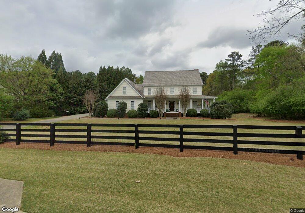
560 Owens Farm Rd Alpharetta, GA 30004
Estimated Value: $1,338,835 - $1,422,000
4
Beds
5
Baths
4,540
Sq Ft
$304/Sq Ft
Est. Value
About This Home
This home is located at 560 Owens Farm Rd, Alpharetta, GA 30004 and is currently estimated at $1,379,959, approximately $303 per square foot. 560 Owens Farm Rd is a home located in Fulton County with nearby schools including Crabapple Crossing Elementary School, Northwestern Middle School, and Milton High School.
Ownership History
Date
Name
Owned For
Owner Type
Purchase Details
Closed on
May 22, 2001
Sold by
Coyne John F and Coyne Pamela B
Bought by
Coyne John F and Coyne Pamela B
Current Estimated Value
Purchase Details
Closed on
Jun 1, 1999
Sold by
Coyne John F and Coyne Pamela B
Bought by
First Security National Bank
Purchase Details
Closed on
Aug 21, 1997
Sold by
Mcrae & Stolz Inc
Bought by
Pinecrest Homes Inc
Home Financials for this Owner
Home Financials are based on the most recent Mortgage that was taken out on this home.
Original Mortgage
$367,500
Interest Rate
7.52%
Mortgage Type
New Conventional
Create a Home Valuation Report for This Property
The Home Valuation Report is an in-depth analysis detailing your home's value as well as a comparison with similar homes in the area
Home Values in the Area
Average Home Value in this Area
Purchase History
| Date | Buyer | Sale Price | Title Company |
|---|---|---|---|
| Coyne John F | -- | -- | |
| First Security National Bank | $476,102 | -- | |
| Pinecrest Homes Inc | $85,000 | -- |
Source: Public Records
Mortgage History
| Date | Status | Borrower | Loan Amount |
|---|---|---|---|
| Previous Owner | Pinecrest Homes Inc | $367,500 |
Source: Public Records
Tax History Compared to Growth
Tax History
| Year | Tax Paid | Tax Assessment Tax Assessment Total Assessment is a certain percentage of the fair market value that is determined by local assessors to be the total taxable value of land and additions on the property. | Land | Improvement |
|---|---|---|---|---|
| 2025 | $1,338 | $474,520 | $100,320 | $374,200 |
| 2023 | $13,394 | $474,520 | $100,320 | $374,200 |
| 2022 | $6,706 | $288,120 | $114,680 | $173,440 |
| 2021 | $6,621 | $272,000 | $59,680 | $212,320 |
| 2020 | $6,721 | $272,000 | $59,680 | $212,320 |
| 2019 | $1,204 | $272,000 | $59,680 | $212,320 |
| 2018 | $6,425 | $239,720 | $61,560 | $178,160 |
| 2017 | $6,946 | $250,000 | $100,320 | $149,680 |
| 2016 | $6,945 | $250,000 | $100,320 | $149,680 |
| 2015 | $7,934 | $295,920 | $100,320 | $195,600 |
| 2014 | $7,137 | $245,560 | $100,880 | $144,680 |
Source: Public Records
Map
Nearby Homes
- 13250 Birmingham Hwy
- 601 Dorris Rd
- 2200 Cortland Rd
- 900 Crabapple Hill
- 2098 Cortland Rd Unit 31
- 13095 Freemanville Rd
- 13039 Freemanville Rd
- 1950 Heritage Walk
- 507 Branyan Trail
- 13630 Birmingham Hwy
- 85 Arabian Ave Unit 2
- 257 Lask Ln
- 249 Lask Ln
- 12575 Broadwell Rd
- 380 Creek Point
- 245 Lask Ln
- 237 Lask Ln
- 570 Owens Farm Rd
- 550 Owens Farm Rd
- 550 Owens Farm Rd Unit 1
- 545 Owens Farm Rd Unit 545
- 545 Owens Farm Rd
- 535 Owens Farm Rd
- 580 Owens Farm Rd
- 540 Owens Farm Rd
- 13196 Birmingham Hwy
- 555 Owens Farm Rd
- 525 Owens Farm Rd Unit 1
- 13160 Birmingham Hwy
- 590 Owens Farm Rd
- 13198 Birmingham Hwy
- 0 Owens Farm Rd Unit 3285752
- 515 Owens Farm Rd
- 600 Owens Farm Rd
- 13170 Birmingham Hwy
- 530 Owens Farm Rd
- 13190 Birmingham Hwy