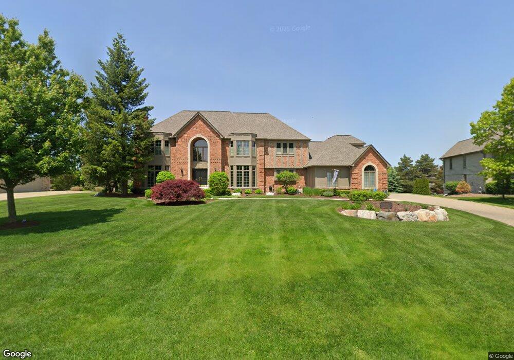
5742 Murfield Dr Rochester, MI 48306
Estimated Value: $959,244 - $1,474,000
4
Beds
6
Baths
4,191
Sq Ft
$278/Sq Ft
Est. Value
About This Home
This home is located at 5742 Murfield Dr, Rochester, MI 48306 and is currently estimated at $1,167,061, approximately $278 per square foot. 5742 Murfield Dr is a home located in Oakland County with nearby schools including Brewster Elementary School, Van Hoosen Middle School, and Rochester Adams High School.
Ownership History
Date
Name
Owned For
Owner Type
Purchase Details
Closed on
Aug 26, 2019
Sold by
Szydlowski Mark A
Bought by
Szydlowski Mark A and Szydlowski Dione J
Current Estimated Value
Purchase Details
Closed on
Jun 8, 2011
Sold by
Obrien Kenneth J and Obrien Roseann
Bought by
Szydlowski Mark A and Szydlowski Mark
Purchase Details
Closed on
Sep 15, 1997
Sold by
Rutkowski Wallace A
Bought by
O'Brien Kenneth J
Home Financials for this Owner
Home Financials are based on the most recent Mortgage that was taken out on this home.
Original Mortgage
$480,000
Interest Rate
7.42%
Create a Home Valuation Report for This Property
The Home Valuation Report is an in-depth analysis detailing your home's value as well as a comparison with similar homes in the area
Home Values in the Area
Average Home Value in this Area
Purchase History
| Date | Buyer | Sale Price | Title Company |
|---|---|---|---|
| Szydlowski Mark A | -- | None Available | |
| Szydlowski Mark A | $425,000 | None Available | |
| O'Brien Kenneth J | $613,000 | -- |
Source: Public Records
Mortgage History
| Date | Status | Borrower | Loan Amount |
|---|---|---|---|
| Previous Owner | O'Brien Kenneth J | $480,000 |
Source: Public Records
Tax History Compared to Growth
Tax History
| Year | Tax Paid | Tax Assessment Tax Assessment Total Assessment is a certain percentage of the fair market value that is determined by local assessors to be the total taxable value of land and additions on the property. | Land | Improvement |
|---|---|---|---|---|
| 2024 | $5,132 | $396,890 | $0 | $0 |
| 2023 | $4,935 | $368,100 | $0 | $0 |
| 2022 | $7,323 | $345,540 | $0 | $0 |
| 2021 | $6,834 | $344,040 | $0 | $0 |
| 2020 | $4,768 | $336,250 | $0 | $0 |
| 2019 | $7,201 | $328,780 | $0 | $0 |
| 2018 | $7,281 | $325,800 | $0 | $0 |
| 2017 | $7,152 | $319,000 | $0 | $0 |
| 2016 | $7,103 | $308,370 | $0 | $0 |
| 2015 | -- | $292,570 | $0 | $0 |
| 2014 | -- | $253,210 | $0 | $0 |
| 2011 | -- | $262,500 | $0 | $0 |
Source: Public Records
Map
Nearby Homes
- 5724 Murfield Dr
- 2821 Addison Cir S
- 5826 Murfield Dr
- 3185 Saint James Ct
- 2750 Castlemartin Ct Unit 22
- 5350 Brewster Rd
- 2794 Castlemartin Ct
- 2879 Hastings Ct Unit 73
- 3582 Tremonte Cir S Unit 276
- 3577 Oakmonte Blvd
- 3522 Oakmonte Blvd Unit 115
- 3574 Oakmonte Blvd
- 2935 Woodford Cir
- 1906 Independence Ct
- 3273 Salem Dr
- 1609 Kilburn Rd N
- 1701 Silver Bell Rd
- 0000 Silver Bell Rd
- 5537 Orchard Ridge Dr
- 5700 Rolling Hills Dr
- 5750 Murfield Dr
- 2929 Addison Cir S
- 2929 Addison Cir N
- 2947 Addison Cir S
- 2907 Addison Cir S
- 5706 Murfield Dr
- 5760 Murfield Dr
- 5757 Lochmoor Ct
- 2889 Addison Cir S
- 5744 Lochmoor Ct
- 2969 Addison Cir S
- 2865 Addison Cir S
- 5779 Murfield Dr
- 5698 Murfield Dr
- 5770 Murfield Dr
- 5709 Murfield Dr
- 0 Murfield Unit 29006728
- 2843 Addison Cir N
- 2843 Addison Cir S
- 2966 Addison Cir S