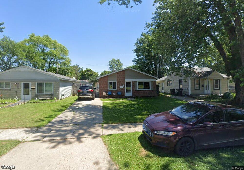
5855 Harold St Taylor, MI 48180
Estimated Value: $152,000 - $163,000
3
Beds
1
Bath
1,001
Sq Ft
$156/Sq Ft
Est. Value
About This Home
This home is located at 5855 Harold St, Taylor, MI 48180 and is currently estimated at $156,318, approximately $156 per square foot. 5855 Harold St is a home located in Wayne County with nearby schools including Clarence Randall Elementary School, Hoover Middle School, and Taylor High School.
Ownership History
Date
Name
Owned For
Owner Type
Purchase Details
Closed on
Jan 5, 2012
Sold by
Grace Robert and Doty Melissa
Bought by
Jpmorgan Chase Bank National Association
Current Estimated Value
Purchase Details
Closed on
Jul 31, 2007
Sold by
Williams Edward L and Williams Malinda
Bought by
Grace Robert
Purchase Details
Closed on
Oct 27, 1999
Sold by
Mckenz Lawrence Mckenzie
Bought by
Williams Edward L
Create a Home Valuation Report for This Property
The Home Valuation Report is an in-depth analysis detailing your home's value as well as a comparison with similar homes in the area
Home Values in the Area
Average Home Value in this Area
Purchase History
| Date | Buyer | Sale Price | Title Company |
|---|---|---|---|
| Jpmorgan Chase Bank National Association | $12,000 | None Available | |
| Grace Robert | $89,900 | Multiple | |
| Williams Edward L | $62,000 | -- |
Source: Public Records
Tax History Compared to Growth
Tax History
| Year | Tax Paid | Tax Assessment Tax Assessment Total Assessment is a certain percentage of the fair market value that is determined by local assessors to be the total taxable value of land and additions on the property. | Land | Improvement |
|---|---|---|---|---|
| 2025 | $1,307 | $67,600 | $0 | $0 |
| 2024 | $1,307 | $62,800 | $0 | $0 |
| 2023 | $1,570 | $54,400 | $0 | $0 |
| 2022 | $1,247 | $51,700 | $0 | $0 |
| 2021 | $1,380 | $44,400 | $0 | $0 |
| 2020 | $1,627 | $38,500 | $0 | $0 |
| 2019 | $136,195 | $34,200 | $0 | $0 |
| 2018 | $1,071 | $26,400 | $0 | $0 |
| 2017 | $1,189 | $26,200 | $0 | $0 |
| 2016 | $1,346 | $25,500 | $0 | $0 |
| 2015 | $2,420 | $24,200 | $0 | $0 |
| 2013 | $2,580 | $26,800 | $0 | $0 |
| 2012 | $1,164 | $26,200 | $7,600 | $18,600 |
Source: Public Records
Map
Nearby Homes
- 5961 Marvin St
- 6075 Duncan St
- 5845 Beech Daly Rd
- 5961 Beech Daly Rd
- 25965 Currier St
- 6179 Fellrath St
- 5993 John Daly St
- 5842 Janet St
- 26106 Powers Ave
- 5904 Janet St
- 5970 John Daly St
- 6319 Duncan St
- 6338 Marvin St
- 25926 Powers Ave
- 6107 John Daly St
- 6363 Mcguire St
- 6349 Beech Daly Rd
- 26532 Powers Ave
- 25908 Beverly Rd
- 25628 Powers Ave
- 5847 Harold St
- 5859 Harold St
- 5839 Harold St
- 5833 Harold St
- 5897 Harold St
- 5868 Fellrath St
- 5860 Fellrath St
- 5878 Fellrath St
- 5886 Fellrath St
- 5846 Fellrath St Unit Bldg-Unit
- 5846 Fellrath St
- 5901 Harold St
- 5834 Fellrath St
- 5892 Fellrath St
- 5917 Harold St
- 5918 Fellrath St
- 5935 Harold St
- 5936 Fellrath St
- 5943 Harold St
- 5948 Fellrath St