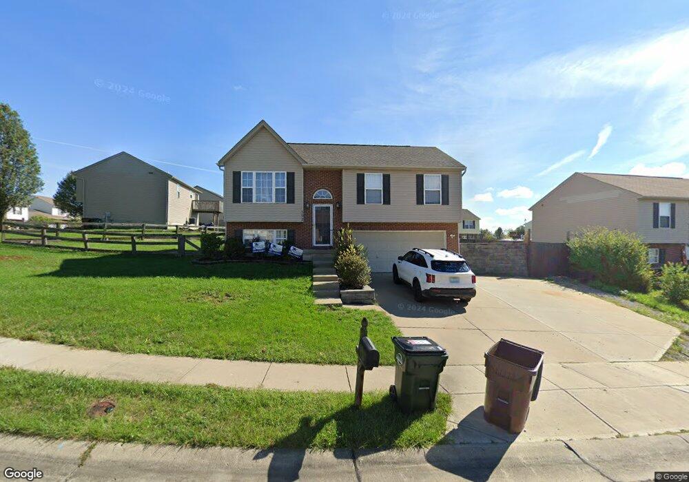
592 Astoria Ct Independence, KY 41051
Estimated Value: $254,000 - $261,401
3
Beds
3
Baths
976
Sq Ft
$265/Sq Ft
Est. Value
About This Home
This home is located at 592 Astoria Ct, Independence, KY 41051 and is currently estimated at $258,600, approximately $264 per square foot. 592 Astoria Ct is a home located in Kenton County with nearby schools including Beechgrove Elementary School, Twenhofel Middle School, and Simon Kenton High School.
Ownership History
Date
Name
Owned For
Owner Type
Purchase Details
Closed on
Mar 13, 2018
Sold by
Hoskinds Brad
Bought by
Tanana Llc
Current Estimated Value
Purchase Details
Closed on
Feb 28, 2006
Sold by
Celestial Building Corp
Bought by
Hoskinds Brad and Hoskinds Natasha
Home Financials for this Owner
Home Financials are based on the most recent Mortgage that was taken out on this home.
Original Mortgage
$131,460
Interest Rate
6.05%
Mortgage Type
Construction
Purchase Details
Closed on
Jul 29, 2005
Sold by
Glenhurst Development Llc
Bought by
Celestial Building Corp
Home Financials for this Owner
Home Financials are based on the most recent Mortgage that was taken out on this home.
Original Mortgage
$4,600
Interest Rate
12%
Mortgage Type
Purchase Money Mortgage
Create a Home Valuation Report for This Property
The Home Valuation Report is an in-depth analysis detailing your home's value as well as a comparison with similar homes in the area
Home Values in the Area
Average Home Value in this Area
Purchase History
| Date | Buyer | Sale Price | Title Company |
|---|---|---|---|
| Tanana Llc | $121,100 | None Available | |
| Hoskinds Brad | $132,500 | Lawyers Title Cincinnati Inc | |
| Celestial Building Corp | $31,000 | Lawyers Title Cincinnati Inc |
Source: Public Records
Mortgage History
| Date | Status | Borrower | Loan Amount |
|---|---|---|---|
| Previous Owner | Hoskinds Brad | $131,460 | |
| Previous Owner | Celestial Building Corp | $4,600 |
Source: Public Records
Tax History Compared to Growth
Tax History
| Year | Tax Paid | Tax Assessment Tax Assessment Total Assessment is a certain percentage of the fair market value that is determined by local assessors to be the total taxable value of land and additions on the property. | Land | Improvement |
|---|---|---|---|---|
| 2024 | $1,719 | $140,300 | $30,000 | $110,300 |
| 2023 | $1,771 | $140,300 | $30,000 | $110,300 |
| 2022 | $1,835 | $140,300 | $30,000 | $110,300 |
| 2021 | $1,862 | $140,300 | $30,000 | $110,300 |
| 2020 | $1,651 | $121,100 | $25,000 | $96,100 |
| 2019 | $1,655 | $121,100 | $25,000 | $96,100 |
| 2018 | $1,689 | $123,000 | $25,000 | $98,000 |
| 2017 | $1,643 | $123,000 | $25,000 | $98,000 |
| 2015 | $1,529 | $118,000 | $30,000 | $88,000 |
| 2014 | $1,508 | $118,000 | $30,000 | $88,000 |
Source: Public Records
Map
Nearby Homes
- 604 Astoria Ct
- 660 Ackerly Dr
- 586 Cutter Ln
- 603 Branch Ct
- 611 Berlander Dr
- 622 Badger Ct
- 10720 Hanover Ct
- 10470 Travis St
- 558 Tupelo Dr
- 10690 Melbury Ct Unit 305GL
- 10694 Melbury Ct Unit 306GL
- 10724 Melbury Ct Unit 287GL
- The Westchester Plan at The Greens of Glenhurst
- The Ella Marie Plan at The Greens of Glenhurst
- The Jefferson Plan at The Greens of Glenhurst
- The Leighann Plan at The Greens of Glenhurst
- The Waterson Plan at The Greens of Glenhurst
- The Lancaster Plan at The Greens of Glenhurst
- The Austin Plan at The Greens of Glenhurst
- The Morgan Plan at The Greens of Glenhurst