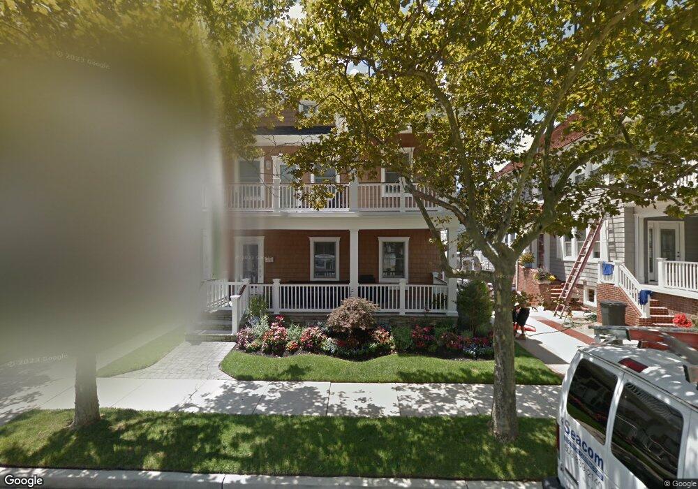
6 S Mansfield Ave Margate City, NJ 08402
Estimated Value: $2,557,000 - $3,118,000
--
Bed
--
Bath
2,903
Sq Ft
$961/Sq Ft
Est. Value
About This Home
This home is located at 6 S Mansfield Ave, Margate City, NJ 08402 and is currently estimated at $2,788,441, approximately $960 per square foot. 6 S Mansfield Ave is a home located in Atlantic County with nearby schools including William H. Ross III Intermediate School, Eugene A. Tighe Middle School, and Blessed Sacrament Regional School.
Ownership History
Date
Name
Owned For
Owner Type
Purchase Details
Closed on
Sep 14, 2011
Sold by
Estate Of Herbert L Stoolman and Schwartz Cathy L
Bought by
Barrett Michael and Barrett Robyn
Current Estimated Value
Home Financials for this Owner
Home Financials are based on the most recent Mortgage that was taken out on this home.
Original Mortgage
$683,000
Outstanding Balance
$57,496
Interest Rate
3.5%
Mortgage Type
New Conventional
Estimated Equity
$2,730,945
Create a Home Valuation Report for This Property
The Home Valuation Report is an in-depth analysis detailing your home's value as well as a comparison with similar homes in the area
Home Values in the Area
Average Home Value in this Area
Purchase History
| Date | Buyer | Sale Price | Title Company |
|---|---|---|---|
| Barrett Michael | $775,000 | Surety Title |
Source: Public Records
Mortgage History
| Date | Status | Borrower | Loan Amount |
|---|---|---|---|
| Open | Barrett Michael | $683,000 |
Source: Public Records
Tax History Compared to Growth
Tax History
| Year | Tax Paid | Tax Assessment Tax Assessment Total Assessment is a certain percentage of the fair market value that is determined by local assessors to be the total taxable value of land and additions on the property. | Land | Improvement |
|---|---|---|---|---|
| 2025 | $17,463 | $1,022,400 | $553,500 | $468,900 |
| 2024 | $17,463 | $1,022,400 | $553,500 | $468,900 |
| 2023 | $16,133 | $1,022,400 | $553,500 | $468,900 |
| 2022 | $16,133 | $1,022,400 | $553,500 | $468,900 |
| 2021 | $15,909 | $1,022,400 | $553,500 | $468,900 |
| 2020 | $15,827 | $1,022,400 | $553,500 | $468,900 |
| 2019 | $15,765 | $1,022,400 | $553,500 | $468,900 |
| 2018 | $15,980 | $1,022,400 | $553,500 | $468,900 |
| 2017 | $16,001 | $1,022,400 | $553,500 | $468,900 |
| 2016 | $15,459 | $1,022,400 | $553,500 | $468,900 |
| 2015 | $15,213 | $1,022,400 | $553,500 | $468,900 |
| 2014 | $14,927 | $1,022,400 | $553,500 | $468,900 |
Source: Public Records
Map
Nearby Homes
- 8509 Atlantic Ave
- 103 S Nassau Ave
- 21 S Kenyon Ave
- 6 N Lancaster Ave
- 12 S Quincy Ave
- 2 N Pembroke Ave
- 17 N Mansfield Ave
- 111 N Mansfield Ave
- 5 N Iroquois Ave
- 116 N Lancaster Ave
- 8904 Ventnor Ave
- 3 Dolphin Dr
- 31 N Jasper Ave
- 104 S Thurlow Ave
- 28 S Huntington Ave
- 121 N Quincy Ave
- 16 S Haverford Ave
- 121 N Rumson Ave
- 215 N Nassau Ave
- 13 N Vendome Ave
- 4 S Mansfield Ave
- 8 S Mansfield Ave
- 7 S Nassau Ave
- 10 S Mansfield Ave
- 5 S Nassau Ave
- 2 S Mansfield Ave
- 11 S Nassau Ave
- 3 S Nassau Ave
- 7 S Mansfield Ave
- 5 S Mansfield Ave
- 9 S Mansfield Ave
- 8601 Atlantic Ave
- 3 S Mansfield Ave
- 8605 Atlantic Ave
- 8600 Ventnor Ave
- 15 S Mansfield Ave
- 8602 Ventnor Ave
- 1 S Mansfield Ave
- 16 S Lancaster Ave
- 14 S Lancaster Ave