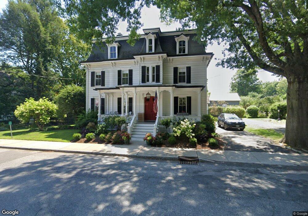
60 W Market St Unit Route 199 Red Hook, NY 12571
Estimated Value: $719,000 - $867,000
4
Beds
3
Baths
2,784
Sq Ft
$279/Sq Ft
Est. Value
About This Home
This home is located at 60 W Market St Unit Route 199, Red Hook, NY 12571 and is currently estimated at $775,585, approximately $278 per square foot. 60 W Market St Unit Route 199 is a home located in Dutchess County with nearby schools including Mill Road Primary School, Mill Road Intermediate School, and Linden Avenue Middle School.
Ownership History
Date
Name
Owned For
Owner Type
Purchase Details
Closed on
Jul 2, 2020
Sold by
Guido Frank and Guido Gail T
Bought by
Acker Charles and Avella Laura
Current Estimated Value
Home Financials for this Owner
Home Financials are based on the most recent Mortgage that was taken out on this home.
Original Mortgage
$510,750
Outstanding Balance
$452,899
Interest Rate
3.1%
Mortgage Type
New Conventional
Estimated Equity
$322,686
Purchase Details
Closed on
May 1, 1998
Sold by
Wicks Douglas F
Bought by
Guido Frank and Guido Gail T
Create a Home Valuation Report for This Property
The Home Valuation Report is an in-depth analysis detailing your home's value as well as a comparison with similar homes in the area
Home Values in the Area
Average Home Value in this Area
Purchase History
| Date | Buyer | Sale Price | Title Company |
|---|---|---|---|
| Acker Charles | $567,500 | None Available | |
| Acker Charles | $567,500 | None Available | |
| Guido Frank | $193,000 | -- | |
| Guido Frank | $193,000 | -- |
Source: Public Records
Mortgage History
| Date | Status | Borrower | Loan Amount |
|---|---|---|---|
| Open | Acker Charles | $510,750 | |
| Closed | Acker Charles | $510,750 |
Source: Public Records
Tax History Compared to Growth
Tax History
| Year | Tax Paid | Tax Assessment Tax Assessment Total Assessment is a certain percentage of the fair market value that is determined by local assessors to be the total taxable value of land and additions on the property. | Land | Improvement |
|---|---|---|---|---|
| 2024 | $15,193 | $589,700 | $66,600 | $523,100 |
| 2023 | $14,110 | $556,300 | $62,800 | $493,500 |
| 2022 | $1,744 | $492,300 | $56,600 | $435,700 |
| 2021 | $4,419 | $420,800 | $56,600 | $364,200 |
| 2020 | $12,580 | $404,600 | $56,600 | $348,000 |
| 2019 | $12,209 | $394,600 | $56,600 | $338,000 |
| 2018 | $12,085 | $394,600 | $56,600 | $338,000 |
| 2017 | $11,932 | $394,600 | $56,600 | $338,000 |
| 2016 | $11,869 | $394,600 | $56,600 | $338,000 |
| 2015 | -- | $394,600 | $56,600 | $338,000 |
| 2014 | -- | $394,600 | $56,600 | $338,000 |
Source: Public Records
Map
Nearby Homes
- 7441 S Broadway
- 16 Cherry St Unit 1 & 2
- 7 Smith St
- 33 Thompson St
- 18 Cambridge Dr
- 11 Cambridge Dr
- 10 Amherst Rd
- 7641 N Broadway
- 7679 Albany Post Rd
- 10 Glen View Dr
- 234 W Market St
- 10 Aspinwall Rd
- 8 Willow Dr
- 13 Chestnut St
- 32 Colonial Dr
- 155 Metzger Rd
- 28 Albie Rd
- 6 Dogwood St
- 252 Route 199
- 80 Fraleigh Ln