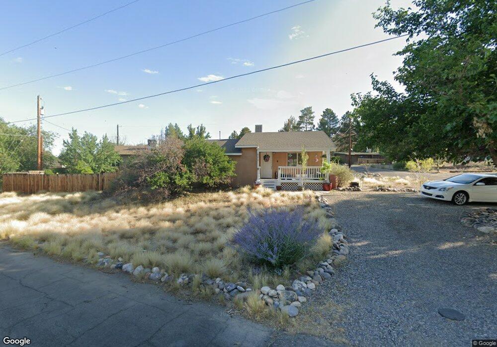
602 Ashurst Dr Farmington, NM 87401
Estimated Value: $198,961 - $230,000
--
Bed
--
Bath
1,312
Sq Ft
$163/Sq Ft
Est. Value
About This Home
This home is located at 602 Ashurst Dr, Farmington, NM 87401 and is currently estimated at $214,240, approximately $163 per square foot. 602 Ashurst Dr is a home located in San Juan County with nearby schools including Apache Elementary School, Tibbetts Middle School, and Farmington High School.
Ownership History
Date
Name
Owned For
Owner Type
Purchase Details
Closed on
Sep 14, 2007
Sold by
Rojax Properties Llc
Bought by
Newland Kenneth D and Newland Bobbi D
Current Estimated Value
Home Financials for this Owner
Home Financials are based on the most recent Mortgage that was taken out on this home.
Original Mortgage
$172,633
Outstanding Balance
$110,026
Interest Rate
6.7%
Mortgage Type
VA
Estimated Equity
$104,214
Purchase Details
Closed on
Jan 25, 2007
Sold by
Rogerts Paul
Bought by
Ameriquest Funding 11 Reo Subsidiary Llc
Create a Home Valuation Report for This Property
The Home Valuation Report is an in-depth analysis detailing your home's value as well as a comparison with similar homes in the area
Home Values in the Area
Average Home Value in this Area
Purchase History
| Date | Buyer | Sale Price | Title Company |
|---|---|---|---|
| Newland Kenneth D | -- | None Available | |
| Ameriquest Funding 11 Reo Subsidiary Llc | -- | None Available |
Source: Public Records
Mortgage History
| Date | Status | Borrower | Loan Amount |
|---|---|---|---|
| Open | Newland Kenneth D | $172,633 |
Source: Public Records
Tax History Compared to Growth
Tax History
| Year | Tax Paid | Tax Assessment Tax Assessment Total Assessment is a certain percentage of the fair market value that is determined by local assessors to be the total taxable value of land and additions on the property. | Land | Improvement |
|---|---|---|---|---|
| 2024 | $955 | $46,167 | $0 | $0 |
| 2023 | $955 | $44,822 | $0 | $0 |
| 2022 | $902 | $43,517 | $0 | $0 |
| 2021 | $865 | $42,250 | $0 | $0 |
| 2020 | $867 | $42,435 | $0 | $0 |
| 2019 | $861 | $42,365 | $0 | $0 |
| 2018 | $871 | $43,284 | $0 | $0 |
| 2017 | $855 | $43,284 | $0 | $0 |
| 2016 | $851 | $43,284 | $0 | $0 |
| 2015 | $837 | $43,284 | $0 | $0 |
| 2014 | -- | $40,973 | $0 | $0 |
Source: Public Records
Map
Nearby Homes
- 636 Ridge Lea Ct
- 1011 N Auburn Ave
- 1805 Brenwood Dr
- XX Brookside Dr
- 1013 N Orchard Dr
- 195 McDonald Rd
- 212 W Sunset Place
- 414 W Comanche St
- XX W Apache St
- LOT 4 XX W 24th St
- 1108 N Dustin Ave
- 511 N Behrend Ave
- 2412 Pheasant Place
- 621 W Apache St
- 200 W 24th St
- 707 W Apache St
- 2413 N Municipal Dr
- 602 N Orchard Ave Unit A - F
- 212 W 25th St
- 712 N Dustin Ave
- 1321 Saint James Place
- 1318 Saint James Place
- 607 Ashurst Dr
- 616 Ashurst Dr
- 611 Ashurst Dr
- 1320 Saint James Place
- 1316 Saint James Place
- 613 Ashurst Dr
- 618 Ashurst Dr
- 615 Ashurst Dr
- 1324 Saint James Place
- 605 Ashurst Dr
- 617 Ashurst Dr
- 1401 Saint James Place
- 619 Ashurst Dr
- 601 Ashurst Dr
- 621 Ashurst Dr
- 606 Glade Rd
- 620 Ashurst Dr
- 601 Glade Rd