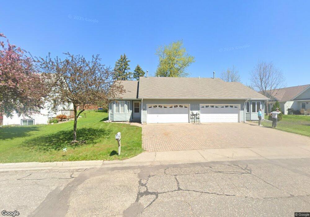
608 Freeman Ave S Delano, MN 55328
Estimated Value: $234,306 - $284,000
2
Beds
1
Bath
998
Sq Ft
$260/Sq Ft
Est. Value
About This Home
This home is located at 608 Freeman Ave S, Delano, MN 55328 and is currently estimated at $259,077, approximately $259 per square foot. 608 Freeman Ave S is a home located in Wright County with nearby schools including Delano Elementary School, Delano Middle School, and Delano Senior High School.
Ownership History
Date
Name
Owned For
Owner Type
Purchase Details
Closed on
Aug 26, 2009
Sold by
Hagerty Michael J and Hagerty Vicki L
Bought by
Harvey Scott
Current Estimated Value
Purchase Details
Closed on
Feb 25, 2009
Sold by
Hud
Bought by
Hagerty Michae and Hagerty Vicki
Purchase Details
Closed on
Mar 24, 2006
Sold by
Lohmann Robert M and Lohmann Jo Ann
Bought by
Pool Brent M
Create a Home Valuation Report for This Property
The Home Valuation Report is an in-depth analysis detailing your home's value as well as a comparison with similar homes in the area
Home Values in the Area
Average Home Value in this Area
Purchase History
| Date | Buyer | Sale Price | Title Company |
|---|---|---|---|
| Harvey Scott | $113,250 | -- | |
| Hagerty Michae | $58,000 | -- | |
| Pool Brent M | $161,000 | -- |
Source: Public Records
Tax History Compared to Growth
Tax History
| Year | Tax Paid | Tax Assessment Tax Assessment Total Assessment is a certain percentage of the fair market value that is determined by local assessors to be the total taxable value of land and additions on the property. | Land | Improvement |
|---|---|---|---|---|
| 2025 | $2,046 | $199,200 | $40,500 | $158,700 |
| 2024 | $2,062 | $194,200 | $42,500 | $151,700 |
| 2023 | $2,118 | $194,800 | $41,500 | $153,300 |
| 2022 | $1,856 | $194,900 | $51,500 | $143,400 |
| 2021 | $1,772 | $148,900 | $26,500 | $122,400 |
| 2020 | $1,784 | $142,500 | $26,500 | $116,000 |
| 2019 | $1,742 | $138,100 | $0 | $0 |
| 2018 | $1,614 | $106,700 | $0 | $0 |
| 2017 | $1,408 | $97,700 | $0 | $0 |
| 2016 | $1,326 | $0 | $0 | $0 |
| 2015 | $1,008 | $0 | $0 | $0 |
| 2014 | -- | $0 | $0 | $0 |
Source: Public Records
Map
Nearby Homes
- 257 6th St NW
- 932 Crossing Way
- 428 Saint Peter Ave E
- 1234 Willowbrook Cir
- 108 Shadywood Ln
- 1257 Willowbrook Cir
- 120 2nd St N
- 327 4th St N
- 316 2nd St N
- xxxx Lincoln St
- 679 Marsh Dr
- 1216 Northwood Dr
- 9560 Us Highway 12
- 9414 U S 12
- 1401 Woods Creek Dr
- 986 Eastwood Cir
- 217 2nd St SW
- 1157 Woods Creek Dr
- 916 Big Woods Dr
- 636 Ridgewood Ln
- 610 Freeman Ave S
- 606 Freeman Ave S
- 751 Rockford Ave E
- 765 Rockford Ave E
- 767 Rockford Ave E
- 763 Rockford Ave E
- 761 Rockford Ave E
- 701 Rockford Ave E
- 759 Rockford Ave E
- 607 Freeman Ave S
- 609 Freeman Ave S
- 604 Freeman Ave S
- 757 Rockford Ave E
- 755 Rockford Ave E
- 605 Freeman Ave S
- 633 Rockford Ave E
- 783 Rockford Ave E
- 603 Freeman Ave S
- 611 1/2 Freeman Ave S
- 611 Freeman Ave S Unit 2 LOWER