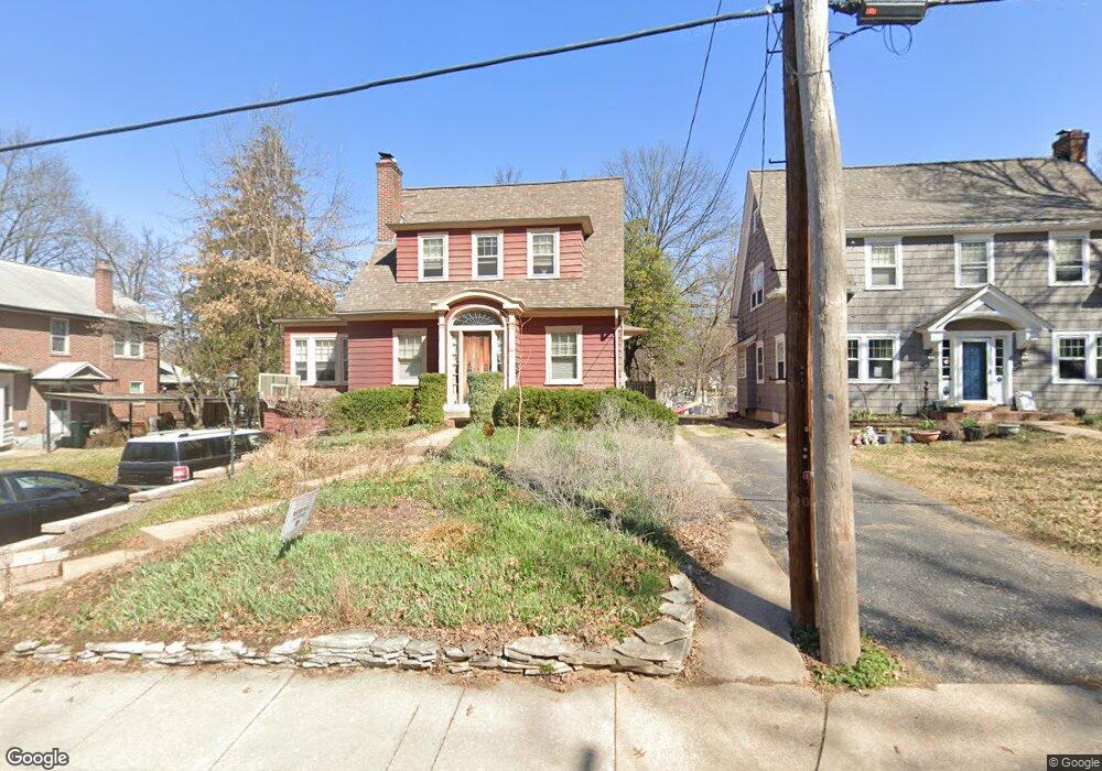
611 Newport Ave Saint Louis, MO 63119
Estimated Value: $428,000 - $525,000
3
Beds
2
Baths
1,664
Sq Ft
$291/Sq Ft
Est. Value
About This Home
This home is located at 611 Newport Ave, Saint Louis, MO 63119 and is currently estimated at $483,834, approximately $290 per square foot. 611 Newport Ave is a home located in St. Louis County with nearby schools including Avery Elementary School, Hixson Middle School, and Webster Groves High School.
Ownership History
Date
Name
Owned For
Owner Type
Purchase Details
Closed on
May 7, 2015
Sold by
Revocable Trust Of Robert Brian Hammo and Hammond Robert Brian Revocable Trust
Bought by
Revocable Trust Of Barbara L Mecker and Mecker Barbara L Revocable Trust
Current Estimated Value
Purchase Details
Closed on
May 31, 2005
Sold by
Rivera Kenneth A and Drew Rivera Leslie S
Bought by
Testroete Mark R and Testroete Susan M
Home Financials for this Owner
Home Financials are based on the most recent Mortgage that was taken out on this home.
Original Mortgage
$122,600
Interest Rate
5.83%
Mortgage Type
Fannie Mae Freddie Mac
Purchase Details
Closed on
Jan 29, 1998
Sold by
Judd Thomas T and Judd Sharon C
Bought by
Rivera Kenneth A and Rivera Leslie S
Home Financials for this Owner
Home Financials are based on the most recent Mortgage that was taken out on this home.
Original Mortgage
$144,000
Interest Rate
6.98%
Create a Home Valuation Report for This Property
The Home Valuation Report is an in-depth analysis detailing your home's value as well as a comparison with similar homes in the area
Home Values in the Area
Average Home Value in this Area
Purchase History
| Date | Buyer | Sale Price | Title Company |
|---|---|---|---|
| Revocable Trust Of Barbara L Mecker | -- | -- | |
| Testroete Mark R | $284,500 | Multiple | |
| Rivera Kenneth A | -- | -- |
Source: Public Records
Mortgage History
| Date | Status | Borrower | Loan Amount |
|---|---|---|---|
| Previous Owner | Testroete Mark R | $122,600 | |
| Previous Owner | Rivera Kenneth A | $144,000 |
Source: Public Records
Tax History Compared to Growth
Tax History
| Year | Tax Paid | Tax Assessment Tax Assessment Total Assessment is a certain percentage of the fair market value that is determined by local assessors to be the total taxable value of land and additions on the property. | Land | Improvement |
|---|---|---|---|---|
| 2025 | $5,188 | $79,160 | $42,470 | $36,690 |
| 2024 | $5,188 | $74,530 | $30,890 | $43,640 |
| 2023 | $5,162 | $74,530 | $30,890 | $43,640 |
| 2022 | $4,762 | $63,800 | $30,890 | $32,910 |
| 2021 | $4,745 | $63,800 | $30,890 | $32,910 |
| 2020 | $4,923 | $61,690 | $30,890 | $30,800 |
| 2019 | $4,888 | $61,690 | $30,890 | $30,800 |
| 2018 | $4,502 | $50,420 | $21,620 | $28,800 |
| 2017 | $4,472 | $50,420 | $21,620 | $28,800 |
| 2016 | $4,497 | $48,550 | $18,530 | $30,020 |
| 2015 | $4,516 | $48,550 | $18,530 | $30,020 |
| 2014 | $4,585 | $47,960 | $13,550 | $34,410 |
Source: Public Records
Map
Nearby Homes
- 610 Cornelia Ave
- 441 Park Rd
- 619 N Bompart Ave
- 400 Marion Ave
- 716 Clark Ave
- 544 Summit Ave
- 808 Greeley Ave
- 112 Oakwood Ave
- 546 Holland Ave
- 450 E Lockwood Ave Unit 303
- 814 Holland Ave
- 840 Marshall Ave
- 946 Newport Ave
- 617 N Elm Ave
- 827 Cornell Ave
- 835 N Forest Ave
- 940 Brookside Ave
- 946 Marshall Ave Unit D
- 2911 Brazeau Ave
- 554 N Laclede Station Rd
- 615 Newport Ave
- 607 Newport Ave
- 516 Cornelia Ave
- 619 Newport Ave
- 518 Cornelia Ave
- 625 Newport Ave
- 524 Cornelia Ave
- 537 Newport Ave
- 320 Park Rd
- 528 Cornelia Ave
- 529 Newport Ave
- 631 Newport Ave
- 519 Cornelia Ave
- 314 Park Rd
- 532 Fairview Ave
- 532 Cornelia Ave
- 527 Newport Ave
- 635 Newport Ave
- 528 Fairview Ave
- 614 Fairview Ave