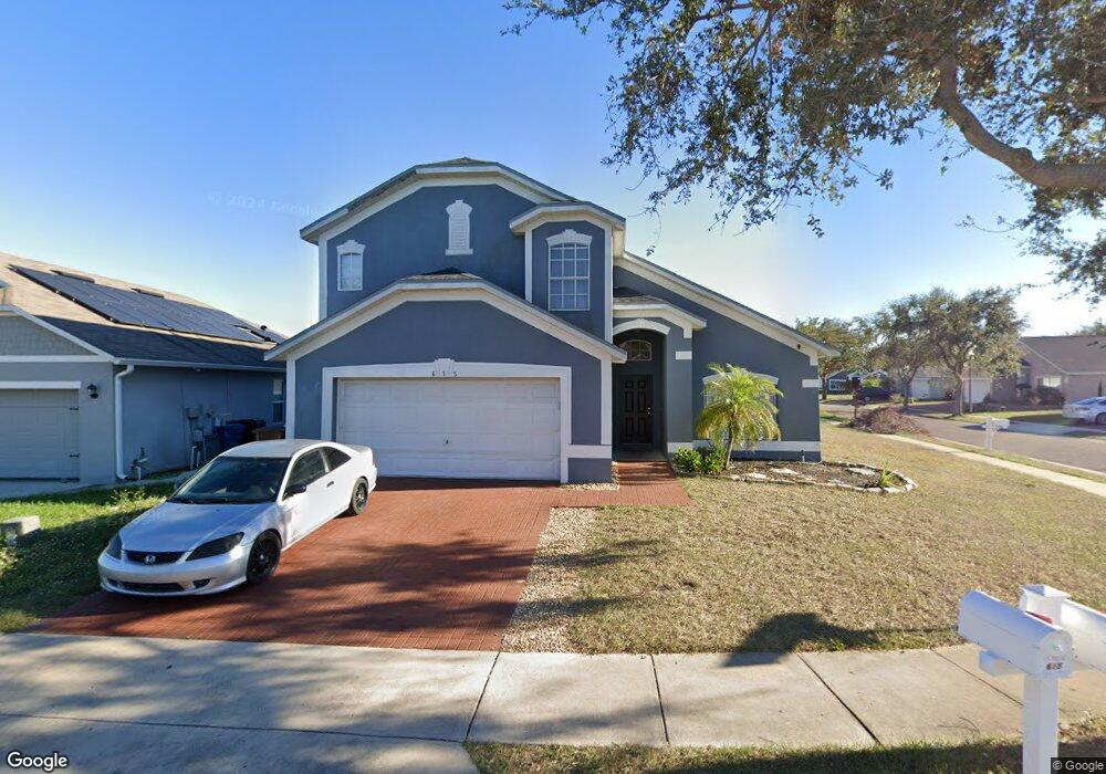
615 Astor Dr Haines City, FL 33844
Estimated Value: $299,929 - $312,000
4
Beds
2
Baths
2,065
Sq Ft
$149/Sq Ft
Est. Value
About This Home
This home is located at 615 Astor Dr, Haines City, FL 33844 and is currently estimated at $306,732, approximately $148 per square foot. 615 Astor Dr is a home located in Polk County with nearby schools including Haines City Senior High School, Dundee Elementary Academy, and Davenport School Of The Arts.
Ownership History
Date
Name
Owned For
Owner Type
Purchase Details
Closed on
Sep 17, 2020
Sold by
City Of Haines City
Bought by
Rodgers Tonya
Current Estimated Value
Purchase Details
Closed on
Jul 31, 2007
Sold by
Nicholson Usa Properties Inc
Bought by
Hamilton Milton and Hamilton Cherane
Home Financials for this Owner
Home Financials are based on the most recent Mortgage that was taken out on this home.
Original Mortgage
$169,330
Interest Rate
6.65%
Mortgage Type
Negative Amortization
Create a Home Valuation Report for This Property
The Home Valuation Report is an in-depth analysis detailing your home's value as well as a comparison with similar homes in the area
Home Values in the Area
Average Home Value in this Area
Purchase History
| Date | Buyer | Sale Price | Title Company |
|---|---|---|---|
| Rodgers Tonya | $600 | None Available | |
| Hamilton Milton | $241,900 | None Available | |
| Nicholson Usa Properties Inc | -- | None Available |
Source: Public Records
Mortgage History
| Date | Status | Borrower | Loan Amount |
|---|---|---|---|
| Previous Owner | Hamilton Milton | $169,330 |
Source: Public Records
Tax History Compared to Growth
Tax History
| Year | Tax Paid | Tax Assessment Tax Assessment Total Assessment is a certain percentage of the fair market value that is determined by local assessors to be the total taxable value of land and additions on the property. | Land | Improvement |
|---|---|---|---|---|
| 2025 | $4,599 | $219,412 | -- | -- |
| 2024 | $4,383 | $199,465 | -- | -- |
| 2023 | $4,383 | $181,332 | $0 | $0 |
| 2022 | $3,935 | $164,847 | $0 | $0 |
| 2021 | $3,548 | $149,861 | $0 | $0 |
| 2020 | $3,270 | $159,071 | $17,000 | $142,071 |
| 2018 | $2,803 | $129,906 | $16,000 | $113,906 |
| 2017 | $2,588 | $102,357 | $0 | $0 |
| 2016 | $2,420 | $93,052 | $0 | $0 |
| 2015 | $2,052 | $84,593 | $0 | $0 |
| 2014 | $1,084 | $65,607 | $0 | $0 |
Source: Public Records
Map
Nearby Homes
- 619 Astor Dr
- 601 Astor Dr
- 928 Chanler Dr
- 323 Weatherby Place
- 2800 U S Highway 17-92 W Unit 75
- 4373 Deleon St
- 1901 U S Highway 17-92 W Unit 81
- 4657 Bernard Blvd
- 3000 US Highway 17 92 W Unit Lot 292
- 4672 Bernard Blvd
- 3000 U S 17 Unit 232
- 3000 U S 17 Unit 95
- 4063 Alissa Ln
- 4022 Alissa Ln
- 1701 W Commerce Ave Unit 192
- 1701 W Commerce Ave Unit 184
- 1701 W Commerce Ave Unit 126
- 1701 W Commerce Ave Unit 201
- 1701 W Commerce Ave Unit 101
- 1701 W Commerce Ave Unit 190
- 167 Winchester Ln
- 170 Winchester Ln
- 621 Astor Dr
- 168 Winchester Ln
- 0 Astor Dr Unit O5201798
- 165 Winchester Ln
- 616 Astor Dr
- 166 Winchester Ln
- 618 Astor Dr
- 614 Astor Dr
- 623 Astor Dr
- 163 Winchester Ln
- 620 Astor Dr
- 164 Winchester Ln
- 611 Astor Dr
- 612 Astor Dr
- 625 Astor Dr
- 514 Winthrop Place
- 161 Winchester Ln
- 622 Astor Dr