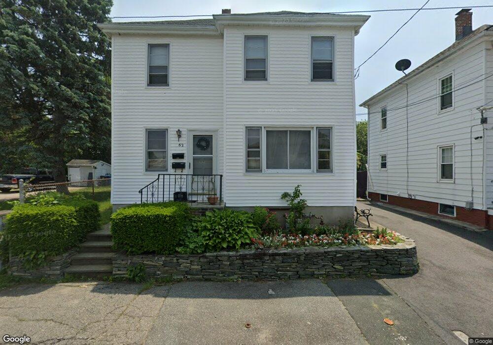
62 Pengrove St Cranston, RI 02920
Village NeighborhoodEstimated Value: $417,772 - $497,000
5
Beds
2
Baths
1,728
Sq Ft
$262/Sq Ft
Est. Value
About This Home
This home is located at 62 Pengrove St, Cranston, RI 02920 and is currently estimated at $451,943, approximately $261 per square foot. 62 Pengrove St is a home located in Providence County with nearby schools including Arlington Elementary School, Hugh B. Bain Middle School, and Cranston High School East.
Ownership History
Date
Name
Owned For
Owner Type
Purchase Details
Closed on
Jul 16, 2024
Sold by
Srey Soriya
Bought by
Soriya Srey Ret and Srey
Current Estimated Value
Purchase Details
Closed on
May 13, 2014
Sold by
Sim Nara and Srey Soriya
Bought by
Srey Soriya
Purchase Details
Closed on
Aug 27, 1996
Sold by
Creati Michael
Bought by
Sim Nara and Men Marith
Create a Home Valuation Report for This Property
The Home Valuation Report is an in-depth analysis detailing your home's value as well as a comparison with similar homes in the area
Home Values in the Area
Average Home Value in this Area
Purchase History
| Date | Buyer | Sale Price | Title Company |
|---|---|---|---|
| Soriya Srey Ret | -- | None Available | |
| Soriya Srey Ret | -- | None Available | |
| Srey Soriya | -- | -- | |
| Srey Soriya | -- | -- | |
| Sim Nara | $81,500 | -- | |
| Sim Nara | $81,500 | -- |
Source: Public Records
Mortgage History
| Date | Status | Borrower | Loan Amount |
|---|---|---|---|
| Previous Owner | Sim Nara | $25,000 | |
| Previous Owner | Sim Nara | $60,000 | |
| Previous Owner | Sim Nara | $69,400 |
Source: Public Records
Tax History Compared to Growth
Tax History
| Year | Tax Paid | Tax Assessment Tax Assessment Total Assessment is a certain percentage of the fair market value that is determined by local assessors to be the total taxable value of land and additions on the property. | Land | Improvement |
|---|---|---|---|---|
| 2025 | $4,709 | $339,300 | $82,900 | $256,400 |
| 2024 | $4,618 | $339,300 | $82,900 | $256,400 |
| 2023 | $4,319 | $228,500 | $57,200 | $171,300 |
| 2022 | $4,230 | $228,500 | $57,200 | $171,300 |
| 2021 | $4,113 | $228,500 | $57,200 | $171,300 |
| 2020 | $3,566 | $171,700 | $44,500 | $127,200 |
| 2019 | $3,566 | $171,700 | $44,500 | $127,200 |
| 2018 | $3,484 | $171,700 | $44,500 | $127,200 |
| 2017 | $3,209 | $139,900 | $34,900 | $105,000 |
| 2016 | $3,141 | $139,900 | $34,900 | $105,000 |
| 2015 | $3,141 | $139,900 | $34,900 | $105,000 |
| 2014 | $2,981 | $130,500 | $34,900 | $95,600 |
Source: Public Records
Map
Nearby Homes
- 7 Cleveland Ave
- 18 Standish Ave
- 174 Gansett Ave
- 1303 Cranston St
- 2 Gansett Ave
- 24-26 Pendleton St
- 761 Dyer Ave
- 0 Doane St
- 1250 Cranston St
- 9 Southern St
- 18 Doane St
- 80 Packard St
- 63 Packard St
- 70 Florida Ave
- 0 Fiat Ave
- 60 Lowell St
- 92 Rhode Island St
- 145 Harmon Ave
- 1574 Cranston St
- 14 New Hampshire St