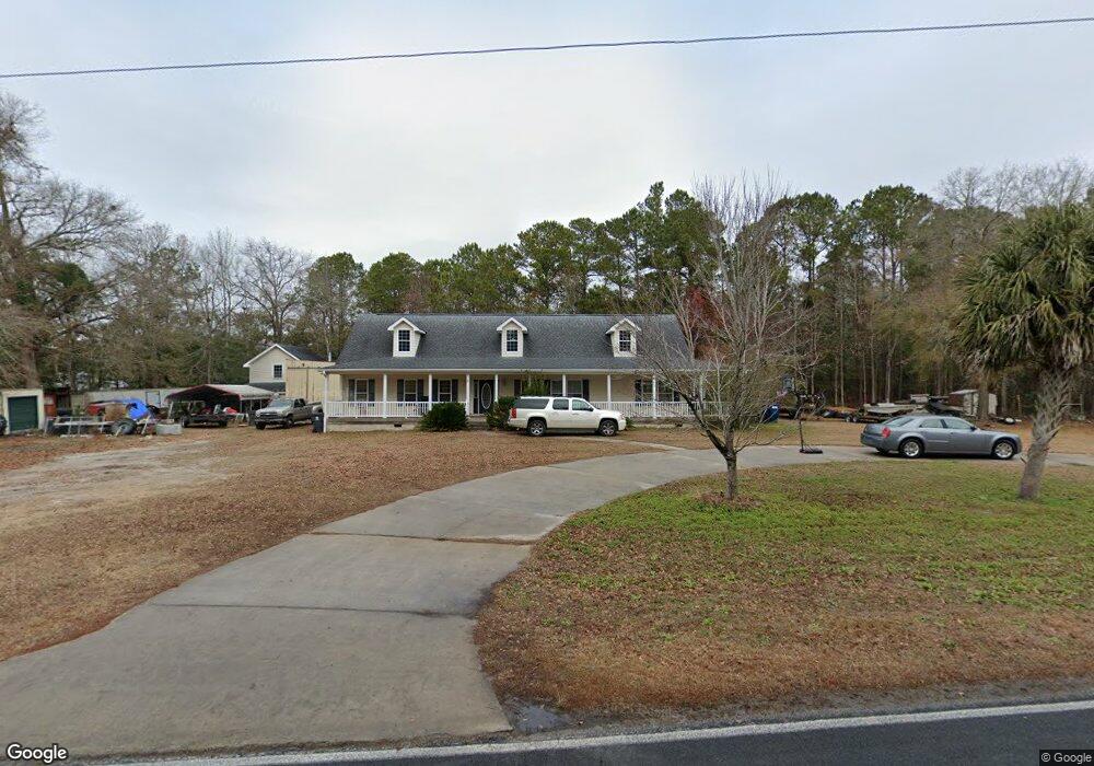
630 Taft Rd SW Supply, NC 28462
Estimated Value: $350,000 - $543,608
3
Beds
2
Baths
2,160
Sq Ft
$195/Sq Ft
Est. Value
About This Home
This home is located at 630 Taft Rd SW, Supply, NC 28462 and is currently estimated at $420,152, approximately $194 per square foot. 630 Taft Rd SW is a home located in Brunswick County with nearby schools including Virginia Williamson Elementary School, Cedar Grove Middle School, and West Brunswick High School.
Ownership History
Date
Name
Owned For
Owner Type
Purchase Details
Closed on
Apr 20, 2005
Sold by
Mascot Homes Inc
Bought by
Helton Sheila and Helton Jimmie
Current Estimated Value
Home Financials for this Owner
Home Financials are based on the most recent Mortgage that was taken out on this home.
Original Mortgage
$175,200
Outstanding Balance
$90,469
Interest Rate
5.79%
Mortgage Type
Commercial
Estimated Equity
$329,683
Create a Home Valuation Report for This Property
The Home Valuation Report is an in-depth analysis detailing your home's value as well as a comparison with similar homes in the area
Home Values in the Area
Average Home Value in this Area
Purchase History
| Date | Buyer | Sale Price | Title Company |
|---|---|---|---|
| Helton Sheila | $219,000 | None Available |
Source: Public Records
Mortgage History
| Date | Status | Borrower | Loan Amount |
|---|---|---|---|
| Open | Helton Sheila | $175,200 | |
| Closed | Helton Sheila | $21,900 |
Source: Public Records
Tax History Compared to Growth
Tax History
| Year | Tax Paid | Tax Assessment Tax Assessment Total Assessment is a certain percentage of the fair market value that is determined by local assessors to be the total taxable value of land and additions on the property. | Land | Improvement |
|---|---|---|---|---|
| 2025 | $1,249 | $248,170 | $30,890 | $217,280 |
| 2024 | $1,249 | $248,170 | $30,890 | $217,280 |
| 2023 | $1,334 | $248,170 | $30,890 | $217,280 |
| 2022 | $1,334 | $192,600 | $24,710 | $167,890 |
| 2021 | $1,334 | $192,600 | $24,710 | $167,890 |
| 2020 | $1,334 | $192,600 | $24,710 | $167,890 |
| 2019 | $1,259 | $24,710 | $24,710 | $0 |
| 2018 | $1,303 | $21,620 | $21,620 | $0 |
| 2017 | $1,303 | $21,620 | $21,620 | $0 |
| 2016 | $1,253 | $21,620 | $21,620 | $0 |
| 2015 | $1,253 | $217,110 | $21,620 | $195,490 |
| 2014 | $1,249 | $237,010 | $46,330 | $190,680 |
Source: Public Records
Map
Nearby Homes
- 665 Pelican Roost Dr SW
- 528 Mary Lou Ln SW
- 587 Mary Lou Ln SW
- 1071 Windward Dr N
- 534 Mary Lou Ln SW
- 2.25 Ac Taft Rd SW
- 1114 Windward Dr N
- 712 Sand Castle Dr SW
- 1135 Wilma Ave SW
- 1150 Wilma Ave SW
- 691 Eastwind Dr SW
- 1024 SW Maple View Rd
- 1168 Wilma Ave SW
- 679 Westwind Dr SW
- 1106 S Windward Dr SW
- 613 Southwind Dr SW
- 580 S Windward Dr SW
- 568 S Windward Dr SW
- Midland_2 Plan at Ruffins River Landing
- Cotswold_3 Plan at Ruffins River Landing
- 605 Pelican Roost Dr SW
- 699 Pelican Roost Dr SW
- 695 Pelican Roost Dr SW
- 627 Taft Rd SW
- 594 Taft Rd SW
- 668 Pelican Roost Dr SW
- 569 Taft Rd SW
- 560 Taft Rd SW
- 642 Sea Wind Ct SW
- 678 Taft Rd SW
- 686 Sea Wind Ct SW
- 654 Sea Wind Ct SW
- 686 Taft Rd SW
- 544 Taft Rd SW
- 1040 Wilma Ave SW
- 683 Sea Wind Ct SW
- 698 Pelican Roost Dr SW
- 536 Taft Rd SW
- 1037 Wilma Ave SW
- 580 Mary Lou Ln SW