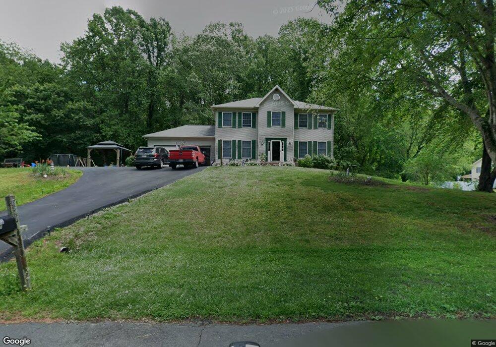
6311 Westmont Ct Dunkirk, MD 20754
Estimated Value: $510,115 - $638,000
--
Bed
3
Baths
2,196
Sq Ft
$271/Sq Ft
Est. Value
About This Home
This home is located at 6311 Westmont Ct, Dunkirk, MD 20754 and is currently estimated at $595,279, approximately $271 per square foot. 6311 Westmont Ct is a home located in Anne Arundel County with nearby schools including Tracey's Elementary School, Southern Middle School, and Southern High School.
Ownership History
Date
Name
Owned For
Owner Type
Purchase Details
Closed on
Nov 20, 1996
Sold by
Gallagher Thomas H
Bought by
Mullady Robert D and Mullady Jeanne M
Current Estimated Value
Purchase Details
Closed on
May 4, 1989
Sold by
Bay Country Estates Ptnshp
Bought by
Gallagher Thomas H
Home Financials for this Owner
Home Financials are based on the most recent Mortgage that was taken out on this home.
Original Mortgage
$131,000
Interest Rate
11.03%
Create a Home Valuation Report for This Property
The Home Valuation Report is an in-depth analysis detailing your home's value as well as a comparison with similar homes in the area
Home Values in the Area
Average Home Value in this Area
Purchase History
| Date | Buyer | Sale Price | Title Company |
|---|---|---|---|
| Mullady Robert D | $207,900 | -- | |
| Gallagher Thomas H | $188,900 | -- |
Source: Public Records
Mortgage History
| Date | Status | Borrower | Loan Amount |
|---|---|---|---|
| Previous Owner | Gallagher Thomas H | $131,000 | |
| Closed | Mullady Robert D | -- |
Source: Public Records
Tax History Compared to Growth
Tax History
| Year | Tax Paid | Tax Assessment Tax Assessment Total Assessment is a certain percentage of the fair market value that is determined by local assessors to be the total taxable value of land and additions on the property. | Land | Improvement |
|---|---|---|---|---|
| 2025 | $4,240 | $445,767 | -- | -- |
| 2024 | $4,240 | $418,633 | $0 | $0 |
| 2023 | $3,478 | $391,500 | $142,600 | $248,900 |
| 2022 | $3,855 | $391,500 | $142,600 | $248,900 |
| 2021 | $7,600 | $391,500 | $142,600 | $248,900 |
| 2020 | $3,707 | $393,000 | $157,600 | $235,400 |
| 2019 | $3,649 | $386,133 | $0 | $0 |
| 2018 | $3,846 | $379,267 | $0 | $0 |
| 2017 | $3,443 | $372,400 | $0 | $0 |
| 2016 | -- | $364,267 | $0 | $0 |
| 2015 | -- | $356,133 | $0 | $0 |
| 2014 | -- | $348,000 | $0 | $0 |
Source: Public Records
Map
Nearby Homes
- 6340 Mckendree Rd
- 411 W Mckendree Rd
- 6095 Solomons Island Rd
- William Plan at The Vineyard
- 5705 Iron Stone Rd
- 6007 Solomons Island Rd
- 461 Jewell Rd
- 75 W Bay Front Rd
- 12761 Carronade Ct
- 0 Fairhaven Rd
- 99 Hummingbird Ct
- 12651 Vigilant Ct
- 531 W Bay Front Rd
- 6281 Franklin Gibson Rd
- 122 Valley View Farm Ln
- 6690 Old Solomons Island Rd
- 60 Friendship Rd
- 2950 Chaney Rd
- 2850 Dunleigh Dr
- 0 Solomons Island Rd
- 6307 Westmont Ct
- 6315 Westmont Ct
- 6310 Westmont Ct
- 6314 Westmont Ct
- 6306 Westmont Ct
- 6319 Westmont Ct
- 6306 Woodcrest Dr
- 6302 Westmont Ct
- 6302 Woodcrest Dr
- 304 Greenridge Dr
- 300 Greenridge Dr
- 284 Greenridge Dr
- 6311 Oaklyn Ct
- 6310 Woodcrest Dr
- 280 Greenridge Dr
- 308 Greenridge Dr
- 287 Greenridge Dr
- 291 Greenridge Dr
- 283 Greenridge Dr
- 6319 Oaklyn Ct