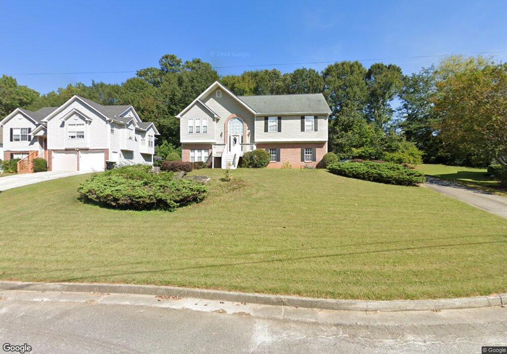
6343 Milo Dr Austell, GA 30168
Estimated Value: $279,000 - $378,000
3
Beds
3
Baths
1,546
Sq Ft
$203/Sq Ft
Est. Value
About This Home
This home is located at 6343 Milo Dr, Austell, GA 30168 and is currently estimated at $313,570, approximately $202 per square foot. 6343 Milo Dr is a home located in Cobb County with nearby schools including Bryant Elementary School, Lindley Middle School, and Pebblebrook High School.
Ownership History
Date
Name
Owned For
Owner Type
Purchase Details
Closed on
Jul 31, 1998
Sold by
Lowden Land Co
Bought by
Randall Hattie A
Current Estimated Value
Home Financials for this Owner
Home Financials are based on the most recent Mortgage that was taken out on this home.
Original Mortgage
$120,143
Outstanding Balance
$24,458
Interest Rate
6.94%
Mortgage Type
FHA
Estimated Equity
$289,112
Create a Home Valuation Report for This Property
The Home Valuation Report is an in-depth analysis detailing your home's value as well as a comparison with similar homes in the area
Home Values in the Area
Average Home Value in this Area
Purchase History
| Date | Buyer | Sale Price | Title Company |
|---|---|---|---|
| Randall Hattie A | $121,000 | -- |
Source: Public Records
Mortgage History
| Date | Status | Borrower | Loan Amount |
|---|---|---|---|
| Open | Randall Hattie A | $120,143 |
Source: Public Records
Tax History Compared to Growth
Tax History
| Year | Tax Paid | Tax Assessment Tax Assessment Total Assessment is a certain percentage of the fair market value that is determined by local assessors to be the total taxable value of land and additions on the property. | Land | Improvement |
|---|---|---|---|---|
| 2025 | $696 | $123,512 | $28,000 | $95,512 |
| 2024 | $698 | $123,512 | $28,000 | $95,512 |
| 2023 | $452 | $110,204 | $18,000 | $92,204 |
| 2022 | $493 | $54,820 | $8,000 | $46,820 |
| 2021 | $493 | $54,820 | $8,000 | $46,820 |
| 2020 | $493 | $54,820 | $8,000 | $46,820 |
| 2019 | $493 | $54,820 | $8,000 | $46,820 |
| 2018 | $416 | $43,700 | $6,000 | $37,700 |
| 2017 | $363 | $43,700 | $6,000 | $37,700 |
| 2016 | $285 | $35,656 | $6,000 | $29,656 |
| 2015 | $304 | $35,656 | $6,000 | $29,656 |
| 2014 | $169 | $22,608 | $0 | $0 |
Source: Public Records
Map
Nearby Homes
- 6445 Sherwood Trail
- 1151 S Gordon Rd
- 1784 Brandemere Dr Unit 3
- 1576 S Gordon Rd
- 6651 Malvin Dr
- 1972 Cox Dr Unit 5
- 6675 S Dillon Rd
- 6581 Coventry Point Unit 1
- 6718 Roscommon Dr
- 6627 Coventry Point
- 2072 Woodbine Cir
- 6992 Ivy Pointe Row
- 1550 Greenbrook Dr
- 1310 Dillon Rd
- 6736 Ivy Log Dr
- 6243 David Ln SW
- 1507 Locust Log Way
- 6084 S Gordon Rd