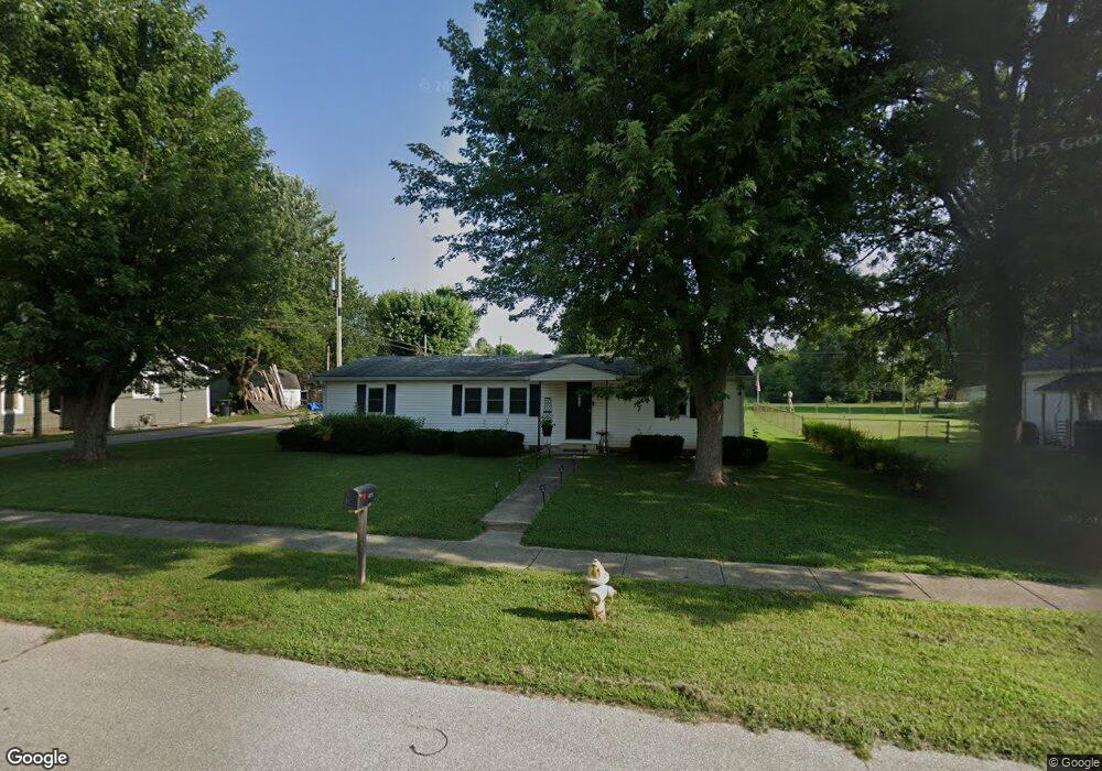
640 Walnut St Whiteland, IN 46184
Estimated Value: $193,000 - $228,259
3
Beds
2
Baths
1,152
Sq Ft
$181/Sq Ft
Est. Value
About This Home
This home is located at 640 Walnut St, Whiteland, IN 46184 and is currently estimated at $209,065, approximately $181 per square foot. 640 Walnut St is a home located in Johnson County with nearby schools including Whiteland Elementary School, Clark-Pleasant Middle School, and Whiteland Community High School.
Ownership History
Date
Name
Owned For
Owner Type
Purchase Details
Closed on
Aug 24, 2022
Sold by
Baf 3 Llc
Bought by
Baf Assets 5 Llc
Current Estimated Value
Purchase Details
Closed on
Nov 29, 2021
Sold by
Fsre Holdings Llc
Bought by
Baf 3 Llc
Purchase Details
Closed on
Jul 10, 2017
Sold by
Warner Lori
Bought by
Harrison Nickolas D
Home Financials for this Owner
Home Financials are based on the most recent Mortgage that was taken out on this home.
Original Mortgage
$89,381
Interest Rate
3.89%
Mortgage Type
VA
Purchase Details
Closed on
May 25, 2012
Sold by
Warner Lori
Bought by
Warner Lori
Create a Home Valuation Report for This Property
The Home Valuation Report is an in-depth analysis detailing your home's value as well as a comparison with similar homes in the area
Home Values in the Area
Average Home Value in this Area
Purchase History
| Date | Buyer | Sale Price | Title Company |
|---|---|---|---|
| Baf Assets 5 Llc | -- | -- | |
| Baf 3 Llc | -- | None Available | |
| Fsre Holdings Llc | -- | None Listed On Document | |
| Harrison Nickolas D | -- | None Available | |
| Warner Lori | -- | None Available |
Source: Public Records
Mortgage History
| Date | Status | Borrower | Loan Amount |
|---|---|---|---|
| Previous Owner | Harrison Nickolas D | $89,381 |
Source: Public Records
Tax History Compared to Growth
Tax History
| Year | Tax Paid | Tax Assessment Tax Assessment Total Assessment is a certain percentage of the fair market value that is determined by local assessors to be the total taxable value of land and additions on the property. | Land | Improvement |
|---|---|---|---|---|
| 2025 | $2,958 | $165,000 | $42,700 | $122,300 |
| 2024 | $2,958 | $141,600 | $42,700 | $98,900 |
| 2023 | $2,953 | $141,600 | $42,700 | $98,900 |
| 2022 | $1,256 | $125,800 | $34,600 | $91,200 |
| 2021 | $976 | $106,200 | $30,800 | $75,400 |
| 2020 | $966 | $103,400 | $19,000 | $84,400 |
| 2019 | $760 | $90,300 | $19,000 | $71,300 |
| 2018 | $753 | $88,000 | $14,600 | $73,400 |
| 2017 | $754 | $88,300 | $14,600 | $73,700 |
| 2016 | $1,810 | $90,500 | $14,600 | $75,900 |
| 2014 | $1,700 | $85,000 | $16,700 | $68,300 |
| 2013 | $1,700 | $84,900 | $16,600 | $68,300 |
Source: Public Records
Map
Nearby Homes
- 630 Walnut St
- 650 E Pearl St
- Henley Plan at Saddlebrook Farms
- Fairfax Plan at Saddlebrook Farms - North
- 841 E Pearl St
- Henley Plan at Saddlebrook Farms - North
- Freeport Plan at Saddlebrook Farms - North
- Johnstown Plan at Saddlebrook Farms - North
- Dayton Plan at Saddlebrook Farms - North
- Chatham Plan at Saddlebrook Farms - North
- Dayton Plan at Saddlebrook Farms
- Harmony Plan at Saddlebrook Farms - North
- Johnstown Plan at Saddlebrook Farms
- Stamford Plan at Saddlebrook Farms - North
- 0 N 200 (Honey Creek Rd ) W Unit MBR21845718
- 905 Saddlebrook Farms Blvd
- 935 Saddlebrook Farms Blvd
- 930 Saddlebrook Farms Blvd
- 60 Benfield Dr
- 50 Benfield Dr