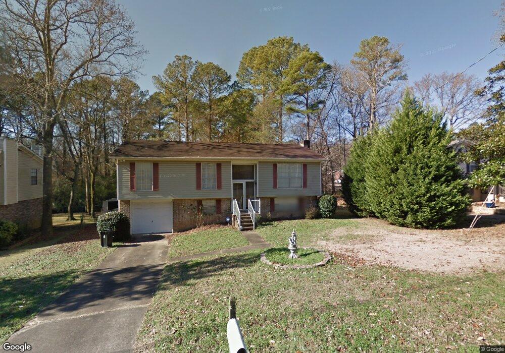
653 20th Ct NE Center Point, AL 35215
Estimated Value: $165,000 - $206,001
3
Beds
2
Baths
1,234
Sq Ft
$145/Sq Ft
Est. Value
About This Home
This home is located at 653 20th Ct NE, Center Point, AL 35215 and is currently estimated at $179,500, approximately $145 per square foot. 653 20th Ct NE is a home located in Jefferson County with nearby schools including Chalkville Elementary School, Clay-Chalkville Middle School, and Clay-Chalkville High School.
Ownership History
Date
Name
Owned For
Owner Type
Purchase Details
Closed on
May 22, 2012
Sold by
Brown Sparkle S
Bought by
King Robert
Current Estimated Value
Purchase Details
Closed on
Jan 28, 2008
Sold by
Ragland Devoris R
Bought by
Brown Sparkle S and King Robert
Home Financials for this Owner
Home Financials are based on the most recent Mortgage that was taken out on this home.
Original Mortgage
$148,174
Interest Rate
6.12%
Mortgage Type
FHA
Purchase Details
Closed on
Jun 12, 2003
Sold by
Perkins John E and Perkins Patricia Louise
Bought by
Ragland Devoris R
Home Financials for this Owner
Home Financials are based on the most recent Mortgage that was taken out on this home.
Original Mortgage
$108,300
Interest Rate
5.68%
Mortgage Type
FHA
Create a Home Valuation Report for This Property
The Home Valuation Report is an in-depth analysis detailing your home's value as well as a comparison with similar homes in the area
Home Values in the Area
Average Home Value in this Area
Purchase History
| Date | Buyer | Sale Price | Title Company |
|---|---|---|---|
| King Robert | -- | -- | |
| Brown Sparkle S | $150,500 | None Available | |
| Ragland Devoris R | $110,000 | -- |
Source: Public Records
Mortgage History
| Date | Status | Borrower | Loan Amount |
|---|---|---|---|
| Previous Owner | Brown Sparkle S | $148,174 | |
| Previous Owner | Ragland Devoris R | $108,300 |
Source: Public Records
Tax History Compared to Growth
Tax History
| Year | Tax Paid | Tax Assessment Tax Assessment Total Assessment is a certain percentage of the fair market value that is determined by local assessors to be the total taxable value of land and additions on the property. | Land | Improvement |
|---|---|---|---|---|
| 2024 | $891 | $21,000 | -- | -- |
| 2022 | $768 | $16,470 | $2,100 | $14,370 |
| 2021 | $700 | $15,020 | $2,100 | $12,920 |
| 2020 | $653 | $14,090 | $2,100 | $11,990 |
| 2019 | $653 | $14,100 | $0 | $0 |
| 2018 | $569 | $12,420 | $0 | $0 |
| 2017 | $569 | $12,420 | $0 | $0 |
| 2016 | $497 | $10,980 | $0 | $0 |
| 2015 | $497 | $12,420 | $0 | $0 |
| 2014 | $818 | $11,760 | $0 | $0 |
| 2013 | $818 | $11,760 | $0 | $0 |
Source: Public Records
Map
Nearby Homes
- 668 20th Ct NE
- 513 20th Ave NE
- 500 20th Ave NE
- 1937 Springlake Ct
- 2212 Shirley Dr
- 421 19th Terrace NE
- 4269 Fieldstone Way
- 416 20th Ct NE
- 1834 Oakleaf Ln
- 1857 Woodvine Ln
- 2236 8th St NE
- 1824 Stonehenge Dr
- 1810 Oakleaf Ln
- 1804 Stonehenge Dr
- 2232 5th St NE
- 1839 Mara Dr
- 1798 Reed Rd NE
- 4604 Fairfax Ct
- 512 22nd Terrace NE
- 915 Rich Rd
- 647 20th Ct NE
- 659 20th Ct NE
- 641 20th Ct NE
- 665 20th Ct NE
- 664 Cort Cir NE
- 640 20th Ct NE
- 635 20th Ct NE
- 1935 7th St NE
- 672 20th Ct NE
- 644 Cort Cir NE
- 629 20th Ct NE
- 636 Cresap Cir NE
- 2005 Reed Rd NE
- 2001 Reed Rd NE
- 623 20th Ct NE
- 1937 Reed Rd NE
- 632 Cresap Cir NE
- 656 Cort Cir NE
- 648 Cort Cir NE
- 1931 7th St NE