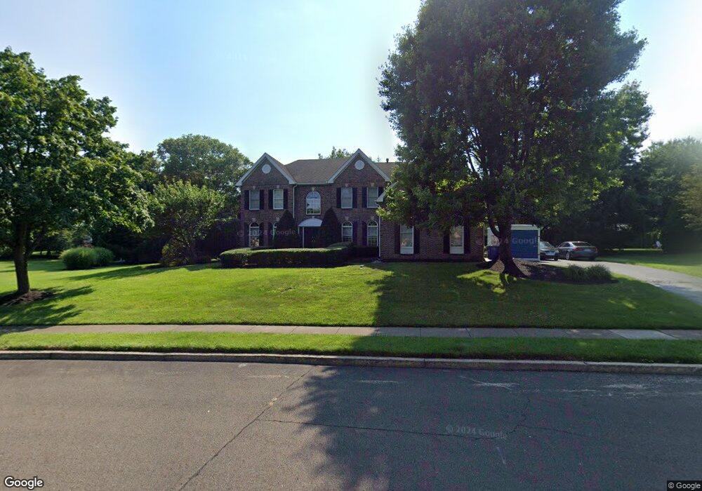
655 Leslie Ln Morrisville, PA 19067
Estimated Value: $993,000 - $1,223,000
4
Beds
4
Baths
4,292
Sq Ft
$256/Sq Ft
Est. Value
About This Home
This home is located at 655 Leslie Ln, Morrisville, PA 19067 and is currently estimated at $1,096,802, approximately $255 per square foot. 655 Leslie Ln is a home located in Bucks County with nearby schools including Edgewood El School, Charles H. Boehm Middle School, and Pennsbury High School.
Ownership History
Date
Name
Owned For
Owner Type
Purchase Details
Closed on
Jun 22, 1995
Sold by
Clouser E Randall and Clouser April P
Bought by
Bernhard Robert B and Bernhard Lynne E
Current Estimated Value
Home Financials for this Owner
Home Financials are based on the most recent Mortgage that was taken out on this home.
Original Mortgage
$387,000
Interest Rate
7.75%
Purchase Details
Closed on
Oct 27, 1994
Sold by
Yardley Estates L P
Bought by
Clouser E Randall and Clouser April P
Home Financials for this Owner
Home Financials are based on the most recent Mortgage that was taken out on this home.
Original Mortgage
$203,000
Interest Rate
8.12%
Create a Home Valuation Report for This Property
The Home Valuation Report is an in-depth analysis detailing your home's value as well as a comparison with similar homes in the area
Home Values in the Area
Average Home Value in this Area
Purchase History
| Date | Buyer | Sale Price | Title Company |
|---|---|---|---|
| Bernhard Robert B | $430,000 | Lawyers Title Insurance Corp | |
| Clouser E Randall | $430,739 | T A Title Insurance Company |
Source: Public Records
Mortgage History
| Date | Status | Borrower | Loan Amount |
|---|---|---|---|
| Closed | Bernhard Robert B | $387,000 | |
| Previous Owner | Clouser E Randall | $203,000 |
Source: Public Records
Tax History Compared to Growth
Tax History
| Year | Tax Paid | Tax Assessment Tax Assessment Total Assessment is a certain percentage of the fair market value that is determined by local assessors to be the total taxable value of land and additions on the property. | Land | Improvement |
|---|---|---|---|---|
| 2025 | $14,683 | $62,010 | $12,920 | $49,090 |
| 2024 | $14,683 | $62,010 | $12,920 | $49,090 |
| 2023 | $13,946 | $62,010 | $12,920 | $49,090 |
| 2022 | $13,644 | $62,010 | $12,920 | $49,090 |
| 2021 | $13,427 | $62,010 | $12,920 | $49,090 |
| 2020 | $13,427 | $62,010 | $12,920 | $49,090 |
| 2019 | $13,161 | $62,010 | $12,920 | $49,090 |
| 2018 | $12,930 | $62,010 | $12,920 | $49,090 |
| 2017 | $12,530 | $62,010 | $12,920 | $49,090 |
| 2016 | $12,385 | $62,010 | $12,920 | $49,090 |
| 2015 | -- | $62,010 | $12,920 | $49,090 |
| 2014 | -- | $62,010 | $12,920 | $49,090 |
Source: Public Records
Map
Nearby Homes
- 1471 Hidden Pond Dr
- 571 Heritage Oak Dr
- 536 Heritage Oak Dr
- 1605 Covington Rd
- 651A Rose Hollow Dr Unit 651A
- 885 Henry Dr
- 833 Winthrop Dr
- 389 Twig Ln
- 1512 Silo Rd
- 963 Hunt Dr
- 5801 Spruce Mill Dr Unit 450
- 1819 Windflower Ln
- 1839 Windflower Ln
- 1835 Windflower Ln
- 1948 Satter Ct
- 1561 Applewood Cir
- 1208 Dickinson Dr
- 2007 Waterford Rd Unit 81
- 7908 Spruce Mill Dr Unit 656
- 404 Sweetbriar Ct