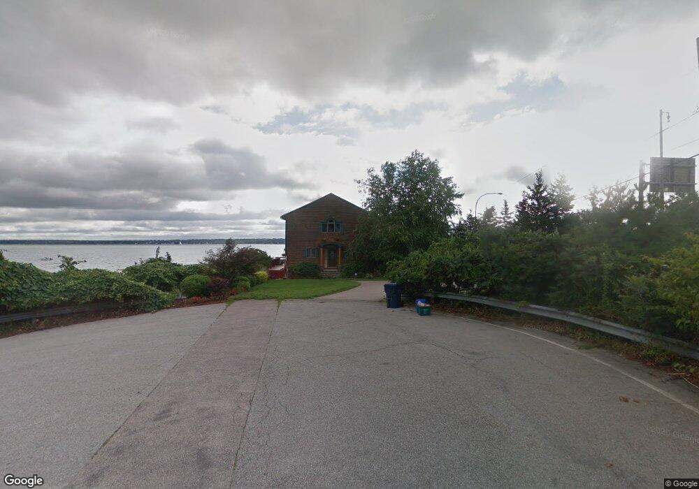
66 Lorelei Dr Saunderstown, RI 02874
Saunderstown NeighborhoodEstimated Value: $883,000 - $1,435,000
3
Beds
3
Baths
2,256
Sq Ft
$513/Sq Ft
Est. Value
About This Home
This home is located at 66 Lorelei Dr, Saunderstown, RI 02874 and is currently estimated at $1,156,266, approximately $512 per square foot. 66 Lorelei Dr is a home located in Washington County with nearby schools including Hamilton Elementary School, Wickford Middle School, and North Kingstown Sr. High School.
Ownership History
Date
Name
Owned For
Owner Type
Purchase Details
Closed on
Nov 6, 2018
Sold by
Walsh Thomas N and Walsh Kathlyn E
Bought by
Walsh Thomas N and Walsh K E
Current Estimated Value
Purchase Details
Closed on
Sep 21, 1999
Sold by
Callaghan Matthew F
Bought by
Walsh Thomas N and Walsh Kathlyne E
Create a Home Valuation Report for This Property
The Home Valuation Report is an in-depth analysis detailing your home's value as well as a comparison with similar homes in the area
Home Values in the Area
Average Home Value in this Area
Purchase History
| Date | Buyer | Sale Price | Title Company |
|---|---|---|---|
| Walsh Thomas N | -- | -- | |
| Walsh Thomas N | $90,500 | -- |
Source: Public Records
Mortgage History
| Date | Status | Borrower | Loan Amount |
|---|---|---|---|
| Previous Owner | Walsh Thomas N | $285,000 | |
| Previous Owner | Walsh Thomas N | $200,000 | |
| Previous Owner | Walsh Thomas N | $322,700 |
Source: Public Records
Tax History Compared to Growth
Tax History
| Year | Tax Paid | Tax Assessment Tax Assessment Total Assessment is a certain percentage of the fair market value that is determined by local assessors to be the total taxable value of land and additions on the property. | Land | Improvement |
|---|---|---|---|---|
| 2025 | $11,939 | $1,081,400 | $767,300 | $314,100 |
| 2024 | $11,101 | $774,100 | $534,500 | $239,600 |
| 2023 | $11,101 | $774,100 | $534,500 | $239,600 |
| 2022 | $10,884 | $774,100 | $534,500 | $239,600 |
| 2021 | $9,013 | $515,000 | $312,000 | $203,000 |
| 2020 | $8,801 | $515,000 | $312,000 | $203,000 |
| 2019 | $8,801 | $515,000 | $312,000 | $203,000 |
| 2018 | $8,703 | $458,800 | $267,300 | $191,500 |
| 2017 | $8,529 | $458,800 | $267,300 | $191,500 |
| 2016 | $8,286 | $458,800 | $267,300 | $191,500 |
| 2015 | $8,569 | $444,000 | $267,300 | $176,700 |
| 2014 | $5,733 | $444,000 | $267,300 | $176,700 |
Source: Public Records
Map
Nearby Homes
- 10 Highland Rd
- 73 Oceanwoods Dr
- 127 Oceanwoods Dr
- 121 Seaside Dr
- 94 Spindrift St
- 174 Seaside Dr
- 51 Salisbury Ave
- 86 Spanker St
- 21 Helm St
- 2180 Tower Hill Rd
- 229 Earle Dr
- 2424 Tower Hill Rd
- 625 N Main Rd
- 63 Duck Cove Rd
- 400 Schooner Ave
- 480 Boston Neck Rd
- 398 Sampan Ave
- 65 Village Hill Ln
- 280 W Reach Dr
- 49 Meadow Sweet Trail
- 0 Bridge Rd Unit 1248015
- 65 Lorelei Dr
- 59 Riptide Dr
- 51 Lorelei Dr
- 56 Riptide Dr
- 51 Riptide Dr
- 45 Lorelei Dr
- 48 Riptide Dr
- 45 Riptide Dr
- 39 Lorelei Dr
- 212 Fleetwood Dr
- 0 Lorelei Dr
- 44 Riptide Dr
- 33 Lorelei Dr
- 52 Spindrift Dr
- 60 Spindrift Dr
- 46 Spindrift Dr
- 200 Fleetwood Dr
- 0 Riptide Dr
- 35 Riptide Dr