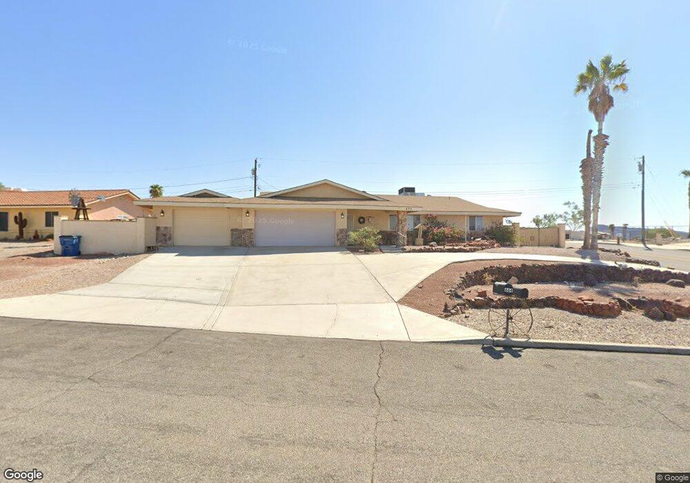
671 Apache Dr Lake Havasu City, AZ 86406
Estimated Value: $451,000 - $642,000
3
Beds
2
Baths
2,116
Sq Ft
$240/Sq Ft
Est. Value
About This Home
This home is located at 671 Apache Dr, Lake Havasu City, AZ 86406 and is currently estimated at $507,299, approximately $239 per square foot. 671 Apache Dr is a home located in Mohave County with nearby schools including Starline Elementary School, Thunderbolt Middle School, and Lake Havasu High School.
Ownership History
Date
Name
Owned For
Owner Type
Purchase Details
Closed on
Sep 14, 2012
Sold by
Walker Kathleen A and Walker Robert E
Bought by
Walker Kathleen A and Walker Rokbert E
Current Estimated Value
Home Financials for this Owner
Home Financials are based on the most recent Mortgage that was taken out on this home.
Original Mortgage
$143,300
Outstanding Balance
$99,064
Interest Rate
3.55%
Mortgage Type
New Conventional
Estimated Equity
$408,235
Purchase Details
Closed on
Apr 23, 2008
Sold by
Suntrust Mortgage Inc
Bought by
Walker Kathleen A and Walker Robert E
Home Financials for this Owner
Home Financials are based on the most recent Mortgage that was taken out on this home.
Original Mortgage
$149,900
Interest Rate
5.8%
Mortgage Type
New Conventional
Purchase Details
Closed on
Dec 12, 2007
Sold by
Ram Residential Iii Llc
Bought by
Suntrust Mortgage Inc
Purchase Details
Closed on
Feb 24, 2006
Sold by
Harbaugh Rene
Bought by
Ram Residential Iii Llc
Home Financials for this Owner
Home Financials are based on the most recent Mortgage that was taken out on this home.
Original Mortgage
$72,800
Interest Rate
6.53%
Mortgage Type
Assumption
Purchase Details
Closed on
Feb 1, 2006
Sold by
Mota Armando
Bought by
Harbaugh Rene
Home Financials for this Owner
Home Financials are based on the most recent Mortgage that was taken out on this home.
Original Mortgage
$72,800
Interest Rate
6.53%
Mortgage Type
Assumption
Purchase Details
Closed on
Jul 1, 2004
Sold by
Anderson Bryan J and Tallakson Julie A
Bought by
Mota Armando
Home Financials for this Owner
Home Financials are based on the most recent Mortgage that was taken out on this home.
Original Mortgage
$150,000
Interest Rate
6.31%
Mortgage Type
Purchase Money Mortgage
Purchase Details
Closed on
Jul 3, 1999
Sold by
Cummins Construction Co Inc
Bought by
Anderson Bryan J and Tallakson Julie A
Home Financials for this Owner
Home Financials are based on the most recent Mortgage that was taken out on this home.
Original Mortgage
$102,606
Interest Rate
11.25%
Create a Home Valuation Report for This Property
The Home Valuation Report is an in-depth analysis detailing your home's value as well as a comparison with similar homes in the area
Home Values in the Area
Average Home Value in this Area
Purchase History
| Date | Buyer | Sale Price | Title Company |
|---|---|---|---|
| Walker Kathleen A | -- | Pioneer Title Agency Inc | |
| Walker Kathleen A | $187,900 | Chicago Title Insurance Co | |
| Suntrust Mortgage Inc | -- | Security Title Agency | |
| Ram Residential Iii Llc | $279,600 | Transnation Title | |
| Harbaugh Rene | $270,000 | Chicago Title Insurance Co | |
| Mota Armando | $114,851 | Chicago Title Ins Co | |
| Anderson Bryan J | -- | Transnation Title Ins Co |
Source: Public Records
Mortgage History
| Date | Status | Borrower | Loan Amount |
|---|---|---|---|
| Open | Walker Kathleen A | $143,300 | |
| Closed | Walker Kathleen A | $149,900 | |
| Previous Owner | Ram Residential Iii Llc | $72,800 | |
| Previous Owner | Harbaugh Rene | $175,500 | |
| Previous Owner | Mota Armando | $150,000 | |
| Previous Owner | Anderson Bryan J | $102,606 | |
| Closed | Anderson Bryan J | $20,250 | |
| Closed | Harbaugh Rene | $94,500 |
Source: Public Records
Tax History Compared to Growth
Tax History
| Year | Tax Paid | Tax Assessment Tax Assessment Total Assessment is a certain percentage of the fair market value that is determined by local assessors to be the total taxable value of land and additions on the property. | Land | Improvement |
|---|---|---|---|---|
| 2026 | $671 | -- | -- | -- |
| 2025 | $1,360 | $47,829 | $0 | $0 |
| 2024 | $1,360 | $50,464 | $0 | $0 |
| 2023 | $1,360 | $41,403 | $0 | $0 |
| 2022 | $1,309 | $31,041 | $0 | $0 |
| 2021 | $1,501 | $28,074 | $0 | $0 |
| 2019 | $1,428 | $21,953 | $0 | $0 |
| 2018 | $1,381 | $20,964 | $0 | $0 |
| 2017 | $1,357 | $18,308 | $0 | $0 |
| 2016 | $1,205 | $16,423 | $0 | $0 |
| 2015 | $1,174 | $14,227 | $0 | $0 |
Source: Public Records
Map
Nearby Homes
- 3135 Cotati Dr
- 2970 War Eagle Dr
- 532 Roanoke Dr
- 2910 Coconino Dr
- 3150 Star Dr
- 3040 Gypsy Dr
- 786 Powder Dr
- 700 Apache Dr
- 3066 Star Dr
- 815 Rolling Hills Plaza N
- 2951 Saddleback Dr
- 2997 Edgewood Dr
- 680 Yosemite Dr
- 691 Rolling Hills Dr
- 3261 Thundercloud Dr
- 2890 Yuma Dr
- 850 Thunderbolt Ave
- 2876 Plaza Del Oro
- 670 Avenida Laredo
- 3306 Cinnamon Dr
- 669 Apache Dr
- 588 Roanoke Dr
- 687 Thunderbolt Ave
- 687 Thunderbolt Ave
- 664 Apache Dr
- 667 Apache Dr
- 685 Thunderbolt Ave
- 660 Apache Dr
- 581 Roanoke Dr
- 591 Roanoke Dr
- 675 Thunderbolt Ave
- 658 Apache Dr
- 665 Apache Dr
- 668 Apache Dr
- 686 Thunderbolt Ave
- 665 Thunderbolt Ave
- 676 Thunderbolt Ave
- 676 Thunderbolt Ave
- 656 Apache Dr
- 696 Thunderbolt Ave